|
0 members (),
744
guests, and
29
robots. |
|
Key:
Admin,
Global Mod,
Mod
|
|
S |
M |
T |
W |
T |
F |
S |
|
1
|
2
|
3
|
4
|
5
|
6
|
7
|
|
8
|
9
|
10
|
11
|
12
|
13
|
14
|
|
15
|
16
|
17
|
18
|
19
|
20
|
21
|
|
22
|
23
|
24
|
25
|
26
|
27
|
28
|
|
29
|
30
|
|
|
|
|
|
|
There are no members with birthdays on this day. |
|
|
Joined: Feb 2001
Posts: 381,903
Launch Director
|
OP

Launch Director
Joined: Feb 2001
Posts: 381,903 |
SPC MD 2120MD 2120 CONCERNING TORNADO WATCH 684... FOR FROM JACKSONVILLE NORTHWARD ACROSS MUCH OF SOUTHEAST GEORGIA AND THE CAROLINAS 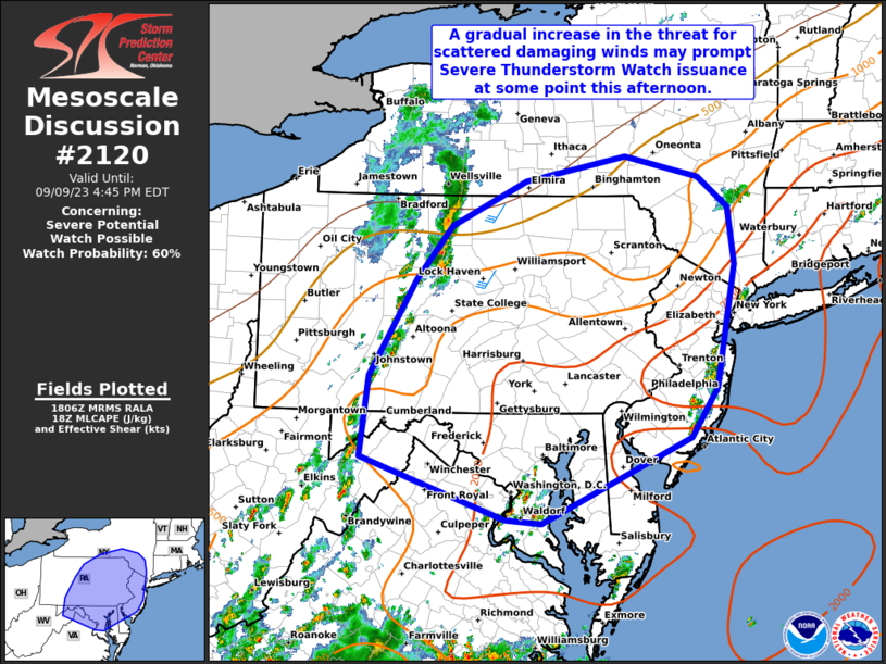
Mesoscale Discussion 2120
NWS Storm Prediction Center Norman OK
0539 PM CDT Thu Sep 26 2024

Areas affected...from Jacksonville northward across much of
southeast Georgia and the Carolinas

Concerning...Tornado Watch 684...

Valid 262239Z - 270315Z

The severe weather threat for Tornado Watch 684 continues.

SUMMARY...The risk of tornadoes is likely to increase/spread
northward through tonight across southeast Georgia, eastern South
Carolina and southeast North Carolina. An isolated strong tornado
cannot be ruled out.

DISCUSSION...Surface analysis shows a warm front/boundary from
southern GA to just off the SC Coast this evening. South of this
boundary, deeper tropical moisture exists with upper 70s F to near
80 F dewpoints, and as such, MLCAPE near the coast is already near
1000 J/kg, with larger values over 1500 J/kg off the eastern FL
Peninsula.

As Hurricane Helene continues northward this evening, wind fields
across the region will strengthen, with 850 mb winds increasing
dramatically after about 03Z. As such, the surface warm front will
move ashore into SC, with further destabilization over parts of
southeast GA as well.

Effective SRH of 300-500 m2/s2 coincident with the instability axis
will be common this evening, with even stronger shear but lower
instability along the western fringe of the warm sector.

An initial band of convection currently extends into the
Jacksonville FL area, and embedded cells could rotate an produce a
brief tornado. Additional bands of storms are likely to develop this
evening and tonight as the warm advection processes increase. Given
such strong shear, an isolated strong tornado cannot be ruled out
late.

..Jewell.. 09/26/2024

...Please see www.spc.noaa.gov for graphic product...

ATTN...WFO...MHX...RAH...ILM...CHS...CAE...JAX...FFC...

LAT...LON   31907960 31088013 30598032 30148070 30028098 30028114
            30378167 30598227 30838293 31168292 31708266 32898197
            33368153 33958106 34827946 34867847 34767791 34337752
            34057749 33697764 32917843 32497896 31907960
Read morehttps://www.spc.noaa.gov/products/md/md2120.html
|
|


CMS The Best Conveyancing solicitors conveyancing quotes throughout the UK
For any webhosting enquiries please email webmaster@aus-city.com
|
|
Forums60
Topics703,075
Posts737,689
Members2,957
| |
Most Online4,158
Jun 21st, 2024
|
|
|


 - Click image for larger picture.")


