|
|
|
0 members (),
1,797
guests, and
27
robots. |
|
Key:
Admin,
Global Mod,
Mod
|
|
S |
M |
T |
W |
T |
F |
S |
|
|
|
|
|
1
|
2
|
3
|
|
4
|
5
|
6
|
7
|
8
|
9
|
10
|
|
11
|
12
|
13
|
14
|
15
|
16
|
17
|
|
18
|
19
|
20
|
21
|
22
|
23
|
24
|
|
25
|
26
|
27
|
28
|
29
|
30
|
31
|
|
There are no members with birthdays on this day. |
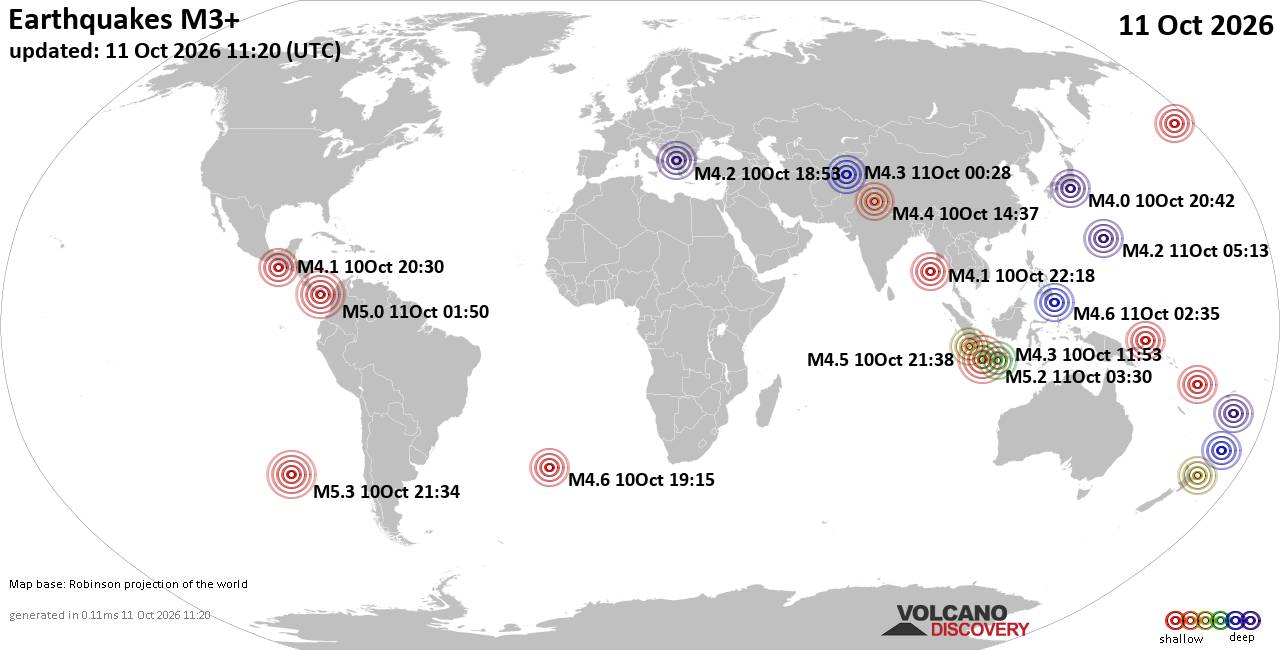
World Earthquake Report for Sunday, 11 October 2026
• M 2.6 - 7 km E of Pearsall, Texas
• M 2.4 - 16 km N of Meadow Lakes, Alaska
• M 2.9 - 16 km NW of Fishhook, Alaska
• M 5.0 - 187 km ENE of Saipan, Northern Mariana Islands
• M 7.7 - 12 km WSW of Pitaloza Arriba, Panama
|
|
|
Joined: Feb 2001
Posts: 678,977
Launch Director
|
|
Launch Director
Joined: Feb 2001
Posts: 678,977 |
SPC Oct 10, 2026 1730 UTC Day 2 Convective OutlookSPC 1730Z Day 2 Outlook 
Day 2 Convective Outlook
NWS Storm Prediction Center Norman OK
1201 PM CDT Sat Oct 10 2026

Valid 111200Z - 121200Z

...THERE IS A SLIGHT RISK OF SEVERE THUNDERSTORMS ACROSS PARTS OF
VIRGINIA AND NORTH CAROLINA...

...SUMMARY...
Isolated strong to severe thunderstorms capable of producing gusty
winds and a tornado or two will be possible across parts of the
Mid-Atlantic on Sunday. Additional strong storms are expected across
parts of the Southwest and Great Basin.

...Carolinas to Mid-Atlantic...

Strong deep-layer flow will overspread the region as the remnants of
Isaias merge with upper troughing from the Ohio Valley to the
Southeast. The surface low is expected to be over the central
Appalachians Sunday morning, and will shift east/northeast across
the Mid-Atlantic through early Monday. A surface front will extend
south of the low and shift east across the region. Within the
pre-frontal warm sector, a very moist airmass will be in place.
Showers and cloudiness are expected across much of the area, and
lapse rates will remain poor, limiting widespread stronger
destabilization. However, a corridor of around 750-1000 J/kg MLCAPE
may develop from eastern/central NC into VA, with more limited
destabilization expected across the broader region.

Given the strong flow field associated with the
remnant/post-tropical system, transient supercell features could
occur in one or more pre-frontal bands of convection. Isolated
strong to severe gusts will be possible, along with a tornado or
two.

...Southwest/Great Basin vicinity...

Strong southwesterly flow aloft will overspread the Lower CO Valley
to the Great Basin/central Rockies as an upper trough slowly digs
and shifts east across the Pacific coast. The remnants of prior
tropical storm Rachel will partially be responsible for enhancement
of midlevel flow, and for modest boundary layer moisture across the
Lower CO Valley. This system is expected to gradually weaken as it
shifts northeast toward the Great Basin/central Rockies through the
period.

Pockets of modest destabilization amid favorable vertical shear will
support bands of convection. Some transient supercell features will
be possible. Given favorable shear and strong background flow, a few
strong gusts and a tornado or two will be possible. The northeast
extent of severe potential remains somewhat uncertain. Instability
will wane with northward extent, but strong deep-layer flow may
continue to support gusty winds with convective showers and isolated
thunderstorms into parts of UT and western CO.

..Leitman.. 10/10/2026
Read morehttps://www.spc.noaa.gov/products/outlook/day2otlk_1730.html
|
|



CMS The Best Conveyancing solicitors conveyancing quotes throughout the UK
For any webhosting enquiries please email webmaster@aus-city.com
|
|
Forums60
Topics868,888
Posts903,684
Members2,960
| |
Most Online102,106
Jul 10th, 2026
|
|
|
|
|

|









































