|
0 members (),
963
guests, and
33
robots. |
|
Key:
Admin,
Global Mod,
Mod
|
|
S |
M |
T |
W |
T |
F |
S |
|
|
1
|
2
|
3
|
4
|
5
|
6
|
|
7
|
8
|
9
|
10
|
11
|
12
|
13
|
|
14
|
15
|
16
|
17
|
18
|
19
|
20
|
|
21
|
22
|
23
|
24
|
25
|
26
|
27
|
|
28
|
29
|
30
|
|
|
|
|
|
There are no members with birthdays on this day. |

#686142
Sat 01 Apr 2023 09:41:AM
|
Joined: Feb 2001
Posts: 381,903
Launch Director
|
OP

Launch Director
Joined: Feb 2001
Posts: 381,903 |
SPC Tornado Watch 103WW 103 TORNADO MS 010730Z - 011200Z 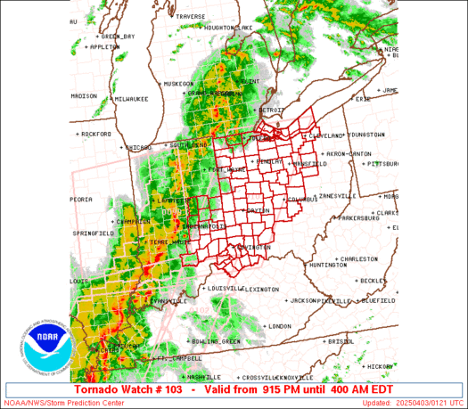
URGENT - IMMEDIATE BROADCAST REQUESTED
Tornado Watch Number 103
NWS Storm Prediction Center Norman OK
230 AM CDT Sat Apr 1 2023

The NWS Storm Prediction Center has issued a

* Tornado Watch for portions of
  East-central Mississippi

* Effective this Saturday morning from 230 AM until 700 AM CDT.

* Primary threats include...
  A couple intense tornadoes possible
  Isolated damaging wind gusts to 70 mph possible

SUMMARY...Southwest portion of broken bands of thunderstorms will
progress east across east-central Mississippi with a continued
threat for a couple tornadoes and isolated damaging winds.

The tornado watch area is approximately along and 45 statute miles
east and west of a line from 15 miles west northwest of Columbus MS
to 60 miles southwest of Meridian MS. For a complete depiction of
the watch see the associated watch outline update (WOUS64 KWNS
WOU3).

PRECAUTIONARY/PREPAREDNESS ACTIONS...

REMEMBER...A Tornado Watch means conditions are favorable for
tornadoes and severe thunderstorms in and close to the watch
area. Persons in these areas should be on the lookout for
threatening weather conditions and listen for later statements
and possible warnings.

&&

OTHER WATCH INFORMATION...CONTINUE...WW 99...WW 101...WW 102...

AVIATION...Tornadoes and a few severe thunderstorms with hail
surface and aloft to 1 inch. Extreme turbulence and surface wind
gusts to 60 knots. A few cumulonimbi with maximum tops to 450. Mean
storm motion vector 26045.

...Grams
Read morehttps://www.spc.noaa.gov/products/watch/ww0103.html
|
|


CMS The Best Conveyancing solicitors conveyancing quotes throughout the UK
For any webhosting enquiries please email webmaster@aus-city.com
|
|
Forums60
Topics684,426
Posts719,036
Members2,957
| |
Most Online3,142
Jan 16th, 2023
|
|
|


 - Click image for larger picture.")


