|
|
|
0 members (),
334
guests, and
26
robots. |
|
Key:
Admin,
Global Mod,
Mod
|
|
S |
M |
T |
W |
T |
F |
S |
|
|
1
|
2
|
3
|
4
|
5
|
6
|
|
7
|
8
|
9
|
10
|
11
|
12
|
13
|
|
14
|
15
|
16
|
17
|
18
|
19
|
20
|
|
21
|
22
|
23
|
24
|
25
|
26
|
27
|
|
28
|
29
|
30
|
|
|
|
|
|
There are no members with birthdays on this day. |

#686143
Sat 01 Apr 2023 10:52:AM
|
Joined: Feb 2001
Posts: 381,903
Launch Director
|
OP

Launch Director
Joined: Feb 2001
Posts: 381,903 |
SPC Tornado Watch 102WW 102 TORNADO KY TN 010650Z - 011100Z 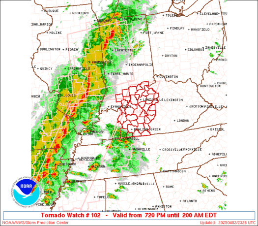
URGENT - IMMEDIATE BROADCAST REQUESTED
Tornado Watch Number 102
NWS Storm Prediction Center Norman OK
250 AM EDT Sat Apr 1 2023

The NWS Storm Prediction Center has issued a

* Tornado Watch for portions of
  Southeast Kentucky
  Eastern Tennessee

* Effective this Saturday morning from 250 AM until 700 AM EDT.

* Primary threats include...
  A couple intense tornadoes possible
  Scattered damaging winds likely with isolated significant gusts
    to 75 mph possible

SUMMARY...Clusters with embedded supercell structures will spread
east through daybreak with a tornado and damaging wind threat.

The tornado watch area is approximately along and 40 statute miles
east and west of a line from 30 miles northeast of London KY to 15
miles east southeast of Chattanooga TN. For a complete depiction of
the watch see the associated watch outline update (WOUS64 KWNS
WOU2).

PRECAUTIONARY/PREPAREDNESS ACTIONS...

REMEMBER...A Tornado Watch means conditions are favorable for
tornadoes and severe thunderstorms in and close to the watch
area. Persons in these areas should be on the lookout for
threatening weather conditions and listen for later statements
and possible warnings.

&&

OTHER WATCH INFORMATION...CONTINUE...WW 98...WW 99...WW 100...WW
101...

AVIATION...Tornadoes and a few severe thunderstorms with hail
surface and aloft to 1 inch. Extreme turbulence and surface wind
gusts to 65 knots. A few cumulonimbi with maximum tops to 400. Mean
storm motion vector 25045.

...Grams
Read morehttps://www.spc.noaa.gov/products/watch/ww0102.html
|
|


CMS The Best Conveyancing solicitors conveyancing quotes throughout the UK
For any webhosting enquiries please email webmaster@aus-city.com
|
|
Forums60
Topics684,257
Posts718,866
Members2,957
| |
Most Online3,142
Jan 16th, 2023
|
|
|
|
|
Copyright 1996 - 2023 by David Cottle. Designed by David Bate Jr. All Rights Reserved.
By using this forum, the user agrees not to transfer any data or technical information received under the agreement, to any other entity without the express approval of the AUS-CITY Forum Admins and/or authors of individual posts (Forum Admins and DoD/USSPACECOM for the analysis of satellite tracking data).
Two-line elements (TLE) and all other satellite data presented and distributed via this forum and e-mail lists of AUS-CITY are distributed with permission from DoD/USSTRATCOM.

Reprise Hosting

|

|


 - Click image for larger picture.")


