|
|
|
0 members (),
495
guests, and
27
robots. |
|
Key:
Admin,
Global Mod,
Mod
|
|
S |
M |
T |
W |
T |
F |
S |
|
|
1
|
2
|
3
|
4
|
5
|
6
|
|
7
|
8
|
9
|
10
|
11
|
12
|
13
|
|
14
|
15
|
16
|
17
|
18
|
19
|
20
|
|
21
|
22
|
23
|
24
|
25
|
26
|
27
|
|
28
|
29
|
30
|
|
|
|
|
|
There are no members with birthdays on this day. |

#716572
Thu 21 Mar 2024 06:50:PM
|
Joined: Feb 2001
Posts: 381,903
Launch Director
|
OP

Launch Director
Joined: Feb 2001
Posts: 381,903 |
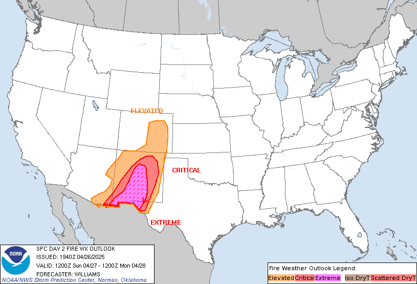
SPC Day 2 Fire Weather OutlookSPC Day 2 Fire Weather Outlook 
Day 2 Fire Weather Outlook
NWS Storm Prediction Center Norman OK
0149 PM CDT Thu Mar 21 2024

Valid 221200Z - 231200Z

The previous forecast remains generally on track with adjustments
made based on trends in latest guidance. Localized elevated
conditions remain possible Friday afternoon - mainly for wind prone
locations in the vicinity of terrain features. See the previous
discussion below for additional details.

..Moore.. 03/21/2024

.PREV DISCUSSION... /ISSUED 0135 AM CDT Thu Mar 21 2024/

...Synopsis...
Elevated fire-weather conditions are possible on Friday afternoon
across portions of West TX. Elsewhere, a progressive weather pattern
and associated widespread precipitation -- along with a trailing
cold front and milder conditions -- will temper any fire-weather
threat.

...West TX...
In the wake of an ejecting, mid-level trough, modest
west-northwesterly flow is forecast over eastern NM and West TX.
This will lead to dry, downsloping flow and deepening, well-mixed
boundary layers across West TX. Critical-level relative humidities
(10-15 percent) are possible across the region by mid-afternoon.
Given a lack of more robust cyclone development, surface wind speeds
are expected to be more tempered around 10-15 mph. Parts of the
region also recently experienced some wetting precipitation, but
this was relatively limited (around 0.1 inches) and localized in
nature. Given forecast ERCs in the 70-80th percentiles and generally
persistent dry and windy conditions, Elevated fire-weather
conditions appear possible in the delineated area Friday afternoon.

...Please see www.spc.noaa.gov/fire for graphic product...
Read morehttps://www.spc.noaa.gov/products/fire_wx/fwdy2.html
|
|


CMS The Best Conveyancing solicitors conveyancing quotes throughout the UK
For any webhosting enquiries please email webmaster@aus-city.com
|
|
Forums60
Topics684,490
Posts719,100
Members2,957
| |
Most Online3,142
Jan 16th, 2023
|
|
|
|
|
Copyright 1996 - 2023 by David Cottle. Designed by David Bate Jr. All Rights Reserved.
By using this forum, the user agrees not to transfer any data or technical information received under the agreement, to any other entity without the express approval of the AUS-CITY Forum Admins and/or authors of individual posts (Forum Admins and DoD/USSPACECOM for the analysis of satellite tracking data).
Two-line elements (TLE) and all other satellite data presented and distributed via this forum and e-mail lists of AUS-CITY are distributed with permission from DoD/USSTRATCOM.


Reprise Hosting


|

|