|
|
|
0 members (),
1,558
guests, and
26
robots. |
|
Key:
Admin,
Global Mod,
Mod
|
|
S |
M |
T |
W |
T |
F |
S |
|
|
|
|
|
|
|
1
|
|
2
|
3
|
4
|
5
|
6
|
7
|
8
|
|
9
|
10
|
11
|
12
|
13
|
14
|
15
|
|
16
|
17
|
18
|
19
|
20
|
21
|
22
|
|
23
|
24
|
25
|
26
|
27
|
28
|
29
|
|
30
|
|
|
|
|
|
|
|
There are no members with birthdays on this day. |

#688006
Sun 07 May 2023 09:54:AM
|
Joined: Feb 2001
Posts: 381,904
Launch Director
|
OP

Launch Director
Joined: Feb 2001
Posts: 381,904 |
SPC MD 703MD 0703 CONCERNING SEVERE POTENTIAL...WATCH UNLIKELY FOR PARTS OF CENTRAL THROUGH NORTHEASTERN NEBRASKA INTO WESTERN IOWA 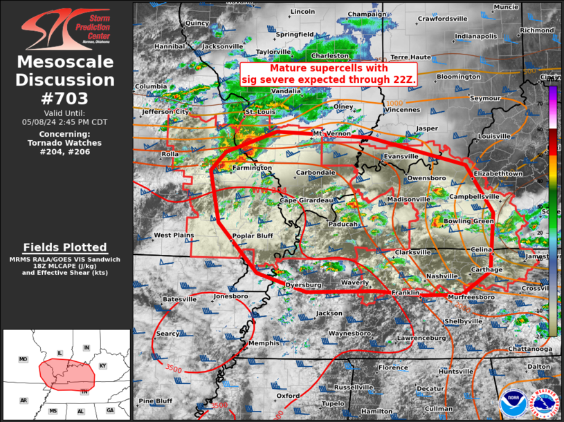
Mesoscale Discussion 0703
NWS Storm Prediction Center Norman OK
0451 AM CDT Sun May 07 2023

Areas affected...parts of central through northeastern Nebraska into
western Iowa

Concerning...Severe potential...Watch unlikely

Valid 070951Z - 071215Z

Probability of Watch Issuance...20 percent

SUMMARY...Strong thunderstorm development, perhaps including an
organizing cluster, may continue to pose at least some risk for
severe weather into and beyond daybreak.  It is not clear that a
severe weather watch will be needed, but trends will continue to be
monitored for this possibility.

DISCUSSION...Thunderstorm activity (currently near Broken Bow
through areas west and northeast of Norfolk) has probably been
producing some severe hail while intensifying and gradually growing
upscale the past hour or two.  This appears to be focused within a
zone of enhanced mid-level warm advection, on the northern periphery
of a plume of warm and capping elevated mixed-layer air.  Given the
steep lapse rates aloft, elevated moisture return may be
contributing to moderately large CAPE, in the presence of strong
cloud-bearing layer shear.

It is possible that the forcing for ascent could contribute to the
evolution of a small organizing cluster across the Sioux City area
through daybreak, with additional thunderstorm development
downstream, to the southeast, across western Iowa.  Despite the
presence of a sizable sub-cloud layer with warm temperatures and
large temperature/dew point spreads, weak ambient flow through this
layer, coupled with at least a shallow relatively cool near-surface
layer, may tend to minimize the risk for the development of strong
surface gusts.

..Kerr/Grams.. 05/07/2023

...Please see www.spc.noaa.gov for graphic product...

ATTN...WFO...DMX...FSD...OAX...GID...LBF...

LAT...LON   42159817 42539612 41759400 40749498 41239676 41139829
            41529908 42159817
Read morehttps://www.spc.noaa.gov/products/md/md0703.html
|
|


CMS The Best Conveyancing solicitors conveyancing quotes throughout the UK
For any webhosting enquiries please email webmaster@aus-city.com
|
|
Entire Thread
|
 SPC MD 703
|
Webmaster
|
Sun 07 May 2023 09:54:AM
|
|
Forums60
Topics748,108
Posts782,769
Members2,958
| |
Most Online4,158
Jun 21st, 2024
|
|
|
|
|
Copyright 1996 - 2024 by David Cottle. Designed by David Bate Jr. All Rights Reserved.
By using this forum, the user agrees not to transfer any data or technical information received under the agreement, to any other entity without the express approval of the AUS-CITY Forum Admins and/or authors of individual posts (Forum Admins and DoD/USSPACECOM for the analysis of satellite tracking data).
Two-line elements (TLE) and all other satellite data presented and distributed via this forum and e-mail lists of AUS-CITY are distributed with permission from DoD/USSTRATCOM.

Reprise Hosting

|

|


 - Click image for larger picture.")


