|
|
|
0 members (),
926
guests, and
44
robots. |
|
Key:
Admin,
Global Mod,
Mod
|
|
S |
M |
T |
W |
T |
F |
S |
|
|
1
|
2
|
3
|
4
|
5
|
6
|
|
7
|
8
|
9
|
10
|
11
|
12
|
13
|
|
14
|
15
|
16
|
17
|
18
|
19
|
20
|
|
21
|
22
|
23
|
24
|
25
|
26
|
27
|
|
28
|
29
|
30
|
31
|
|
|
|
|
There are no members with birthdays on this day. |
hii
by Anonymous - Thu 25 Dec 2025 02:06:AM
|
|
|
|
|
|
|
|
|
|
|
|
|
|
|
|
|
|
|

#690539
Wed 14 Jun 2023 07:49:PM
|
Joined: Feb 2001
Posts: 381,904
Launch Director
|
OP

Launch Director
Joined: Feb 2001
Posts: 381,904 |
SPC PDS Severe Thunderstorm Watch 293WW 293 SEVERE TSTM AR LA MS 141840Z - 150100Z 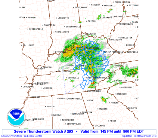
URGENT - IMMEDIATE BROADCAST REQUESTED
Severe Thunderstorm Watch Number 293
NWS Storm Prediction Center Norman OK
140 PM CDT Wed Jun 14 2023

The NWS Storm Prediction Center has issued a

* Severe Thunderstorm Watch for portions of
  Extreme southeast Arkansas
  Northeast Louisiana
  Central Mississippi

* Effective this Wednesday afternoon and evening from 140 PM
  until 800 PM CDT.

...THIS IS A PARTICULARLY DANGEROUS SITUATION...

* Primary threats include...
  Widespread damaging winds and scattered significant gusts to 90
    mph likely
  Scattered large hail and isolated very large hail events to 3
    inches in diameter likely
  A few tornadoes likely

SUMMARY...A supercell cluster is evolving into a bow echo along the
Louisiana/Arkansas border, and this cluster will likely persist
across the remainder of northern Louisiana into central Mississippi
through the afternoon.  A derecho-producing event is probable with
intense damaging wind swaths up to 90 mph.  Embedded supercells will
pose a threat for 1.5-3 inch diameter hail, and  embedded
circulations will also be capable of producing tornadoes.

The severe thunderstorm watch area is approximately along and 55
statute miles north and south of a line from 30 miles northwest of
Monroe LA to 20 miles east of Meridian MS. For a complete depiction
of the watch see the associated watch outline update (WOUS64 KWNS
WOU3).

PRECAUTIONARY/PREPAREDNESS ACTIONS...

REMEMBER...A Severe Thunderstorm Watch means conditions are
favorable for severe thunderstorms in and close to the watch area.
Persons in these areas should be on the lookout for threatening
weather conditions and listen for later statements and possible
warnings. Severe thunderstorms can and occasionally do produce
tornadoes.

&&

OTHER WATCH INFORMATION...CONTINUE...WW 289...WW 290...WW
291...WW 292...

AVIATION...A few severe thunderstorms with hail surface and aloft to
3 inches. Extreme turbulence and surface wind gusts to 80 knots. A
few cumulonimbi with maximum tops to 600. Mean storm motion vector
28050.

...Thompson
Read morehttps://www.spc.noaa.gov/products/watch/ww0293.html
|
|


CMS The Best Conveyancing solicitors conveyancing quotes throughout the UK
For any webhosting enquiries please email webmaster@aus-city.com
|
|
Entire Thread
|
 SPC PDS Severe Thunderstorm Watch 293
|
Webmaster
|
Wed 14 Jun 2023 07:49:PM
|
|
Forums60
Topics753,338
Posts788,030
Members2,958
| |
Most Online12,408
Dec 19th, 2025
|
|
|
|
|
Copyright 1996 - 2024 by David Cottle. Designed by David Bate Jr. All Rights Reserved.
By using this forum, the user agrees not to transfer any data or technical information received under the agreement, to any other entity without the express approval of the AUS-CITY Forum Admins and/or authors of individual posts (Forum Admins and DoD/USSPACECOM for the analysis of satellite tracking data).
Two-line elements (TLE) and all other satellite data presented and distributed via this forum and e-mail lists of AUS-CITY are distributed with permission from DoD/USSTRATCOM.

Reprise Hosting

|

|


 - Click image for larger picture.")


