|
|
|
0 members (),
1,680
guests, and
26
robots. |
|
Key:
Admin,
Global Mod,
Mod
|
|
S |
M |
T |
W |
T |
F |
S |
|
|
|
|
|
1
|
2
|
3
|
|
4
|
5
|
6
|
7
|
8
|
9
|
10
|
|
11
|
12
|
13
|
14
|
15
|
16
|
17
|
|
18
|
19
|
20
|
21
|
22
|
23
|
24
|
|
25
|
26
|
27
|
28
|
29
|
30
|
31
|
|
There are no members with birthdays on this day. |

Volcano earthquake report for Thursday, 22 October 2026
• M 3.0 - 3 km W of Columbia City, Oregon
• M 4.1 - 65 km NE of Tadine, New Caledonia
• M 2.1 - 126 km WSW of Adak, Alaska
• M 1.5 - 26 km E of Honaunau-Napoopoo, Hawaii
• M 2.2 - 69 km SW of Nanwalek, Alaska
|

#726256
Fri 21 Jun 2024 07:32:AM
|
Joined: Feb 2001
Posts: 678,977
Launch Director
|
|
Launch Director
Joined: Feb 2001
Posts: 678,977 |
SPC Jun 21, 2024 0730 UTC Day 3 Severe Thunderstorm OutlookSPC 0730Z Day 3 Outlook 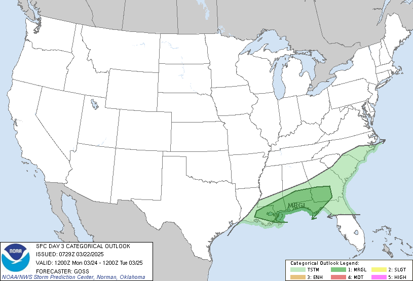
Day 3 Convective Outlook
NWS Storm Prediction Center Norman OK
0230 AM CDT Fri Jun 21 2024

Valid 231200Z - 241200Z

...THERE IS A MARGINAL RISK OF SEVERE THUNDERSTORMS FROM PARTS OF
THE OHIO VALLEY INTO THE NORTHEAST AND MID ATLANTIC...

...SUMMARY...
Isolated severe thunderstorms will be possible on Sunday from parts
of the Northeast and Mid Atlantic into the Ohio Valley.

...New England into the Ohio Valley...
An upper trough is forecast to gradually amplify from the Great
Lakes into the Northeast on Sunday. Guidance continues to vary with
the timing and amplitude of embedded shortwaves within the
larger-scale trough, but in general, one shortwave may move across
New England during the day, while another moves southeast over the
Great Lakes region during the afternoon/evening. A surface low is
generally forecast to move from the upper Great Lakes into southern
New England, as a trailing cold front moves through parts of the
Northeast into the Ohio Valley.

Depending on the potential influence of early-day convection,
moderate buoyancy may develop along/ahead of the cold front, and
thunderstorm development is expected as soon as late morning, with
increasing coverage into the afternoon. Moderate deep-layer shear
from the northern Mid Atlantic into southern New England will
support potential for organized convection, and a few stronger
cells/clusters may be capable of producing damaging wind and perhaps
some hail. A tornado also will be possible, if a supercell or two
can be sustained within moderately enhanced low-level flow/SRH.

Farther southwest, modest northwesterly flow aloft could support a
few strong to severe storms across the Ohio Valley during the
afternoon/evening, with an attendant threat of isolated damaging
wind and hail.

..Dean.. 06/21/2024
Read morehttps://www.spc.noaa.gov/products/outlook/day3otlk_0730.html
|
|



CMS The Best Conveyancing solicitors conveyancing quotes throughout the UK
For any webhosting enquiries please email webmaster@aus-city.com
|
|
Entire Thread
|
 SPC Jun 21, 2024 0730 UTC Day 3 Severe Thunderstorm Outlook |
Webmaster
|
Fri 21 Jun 2024 07:32:AM
|
|
Forums60
Topics889,200
Posts923,997
Members2,960
| |
Most Online102,106
Jul 10th, 2026
|
|
|
|
|

|









































