|
|
|
0 members (),
293
guests, and
21
robots. |
|
Key:
Admin,
Global Mod,
Mod
|
|
S |
M |
T |
W |
T |
F |
S |
|
|
|
|
|
1
|
2
|
3
|
|
4
|
5
|
6
|
7
|
8
|
9
|
10
|
|
11
|
12
|
13
|
14
|
15
|
16
|
17
|
|
18
|
19
|
20
|
21
|
22
|
23
|
24
|
|
25
|
26
|
27
|
28
|
29
|
30
|
31
|
|
There are no members with birthdays on this day. |

#735700
Tue 10 Sep 2024 07:03:AM
|
Joined: Feb 2001
Posts: 381,904
Launch Director
|
OP

Launch Director
Joined: Feb 2001
Posts: 381,904 |
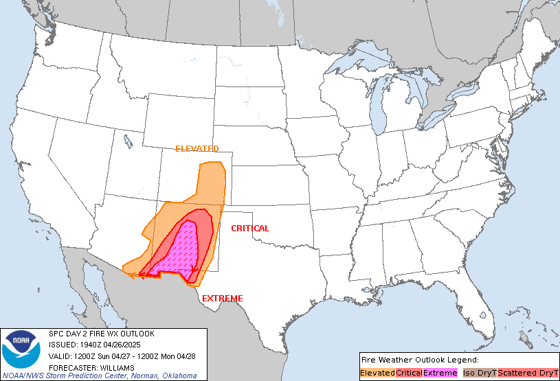
SPC Day 2 Fire Weather OutlookSPC Day 2 Fire Weather Outlook 
Day 2 Fire Weather Outlook
NWS Storm Prediction Center Norman OK
0202 AM CDT Tue Sep 10 2024

Valid 111200Z - 121200Z

...CRITICAL FIRE WEATHER AREA FOR PORTIONS OF THE GREAT BASIN...

...Synopsis...
The upper trough over the western US will quickly intensify
Wednesday, as a shortwave perturbation and mid-level jet streak move
onshore over the West Coast. As the trough strengthens, mid-level
flow over much of the West will increase. A surface low will deepen
over the northern Great Basin, while a cold front moves onshore and
also strengthens. To the east, TS Francine will approach the Gulf
Coast with offshore winds likely over parts of the mid South. Strong
surface winds, low humidity, and thunderstorms over parts of the
West and central US will support critical fire-weather concerns
Wednesday.

...Great Basin...
Ahead of the deepening trough, a potent mid-level jet streak will
move over parts of the western Great Basin beginning early
Wednesday. A deepening surface low in parts of the eastern Basin
will drive 20-25 mph winds over much of NV into western UT.
Augmented by downslope flow off the Sierra and the approaching cold
front, a brief period of winds of 25-30 mph will be possible along
with RH below 15%. Widespread critical fire-weather conditions are
likely over parts of the Great Basin. Fire-weather concerns should
diminish behind the front as cooler and more quiescent conditions
are expected behind the front into early Thursday.

...Lee of the Rockies and High Plains...
As the trough approaches, height falls and stronger flow aloft will
overspread the Rockies and High Plains. A surface low will deepen
first in eastern MT, with a lee trough extending south into the
central High Plains. Near the lee trough, strong southerly winds
will overlap with areas of low RH and drying fine fuels. Elevated
fire weather concerns are expected over parts of the High Plains
Wednesday afternoon and evening.

...Mid South...
As Francine approaches the Gulf Coast Wednesday and Wednesday night,
offshore pressure gradients will increase over parts of the lower MS
Valley and Mid South. While humidity values are not expected to be
overly low with the tropical air mass approaching, strong gusts are
expected to overlap with areas of relatively dry fuels and little
recent rainfall. Brief elevated fire-weather conditions are possible
before rain chances increase into early Thursday.

...Northwest Thunder...
Ahead of the cold front, increasing mid-level moisture and strong
lift from the trough will promote scattered thunderstorms Wednesday
afternoon. Lightning may interact with areas of somewhat drier fuels
over parts of the Northwest and northern Rockies before broader
wetting rainfall develops. However, these storms will likely have
higher precipitation efficiency with a cooler air mass and more
plentiful Pacific moisture in place. This lends significant
uncertainty on the threat for any lightning ignitions.

..Lyons.. 09/10/2024

...Please see www.spc.noaa.gov/fire for graphic product...
Read morehttps://www.spc.noaa.gov/products/fire_wx/fwdy2.html
|
|


CMS The Best Conveyancing solicitors conveyancing quotes throughout the UK
For any webhosting enquiries please email webmaster@aus-city.com
|
|
Entire Thread
|

 SPC Day 2 Fire Weather Outlook
|
Webmaster
|
Tue 10 Sep 2024 07:03:AM
|
|
Forums60
Topics725,626
Posts760,242
Members2,958
| |
Most Online4,158
Jun 21st, 2024
|
|
|
|
|
Copyright 1996 - 2024 by David Cottle. Designed by David Bate Jr. All Rights Reserved.
By using this forum, the user agrees not to transfer any data or technical information received under the agreement, to any other entity without the express approval of the AUS-CITY Forum Admins and/or authors of individual posts (Forum Admins and DoD/USSPACECOM for the analysis of satellite tracking data).
Two-line elements (TLE) and all other satellite data presented and distributed via this forum and e-mail lists of AUS-CITY are distributed with permission from DoD/USSTRATCOM.


Reprise Hosting


|

|