|
|
|
0 members (),
1,953
guests, and
32
robots. |
|
Key:
Admin,
Global Mod,
Mod
|
|
S |
M |
T |
W |
T |
F |
S |
|
|
|
|
1
|
2
|
3
|
4
|
|
5
|
6
|
7
|
8
|
9
|
10
|
11
|
|
12
|
13
|
14
|
15
|
16
|
17
|
18
|
|
19
|
20
|
21
|
22
|
23
|
24
|
25
|
|
26
|
27
|
28
|
29
|
30
|
31
|
|
|
There are no members with birthdays on this day. |

Volcano earthquake report for Friday, 10 Jul 2026
• Moderate mag. 4.2 earthquake - 133 km northwest of Ternate, Kota Ternate, N...
• World Earthquake Report for Friday, 10 July 2026
• Moderate mag. 4.6 earthquake - 17 km southwest of Comalapa, Estado de Chiap...
• Moderate mag. 4.1 earthquake - Olyutorskiy Rayon, 47 km northwest of Tilich...
• Moderate mag. 4.0 earthquake - Hawke's Bay, New Zealand, on Saturday, Jul 1...
|

#739853
Sun 29 Sep 2024 12:19:PM
|
Joined: Feb 2001
Posts: 678,976
Launch Director
|
OP

Launch Director
Joined: Feb 2001
Posts: 678,976 |
Small magnitude 2.6 earthquake 5 km northeast of Ensenada, Mexico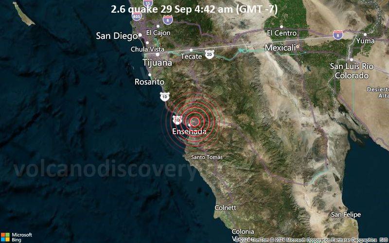 2.6 quake 29 Sep 4:42 am (GMT -7) The United States Geological Survey reported a magnitude 2.6 quake in Mexico near Ensenada, Baja California, 35 minutes ago. The earthquake hit early morning on Sunday, September 29th, 2024, at 4:42 am local time at a shallow depth of 15.5 km. Magnitude and other quake parameters can still change in the coming hours as the agency continues to process seismic data.
Our monitoring service identified a second report from The Incorporated Research Institutions for Seismology (IRIS) which listed the quake at magnitude 2.6 as well. A third agency, the European-Mediterranean Seismological Centre (EMSC), reported the same quake at magnitude 2.5.
Towns or cities near the epicenter where the quake might have been felt as very weak shaking include San Luis (pop. 14) located 1 km from the epicenter, Salvador Rosas Magallon (pop. 1,500) 1 km away, Colonia Gomez Morin (pop. 1,400) 1 km away, Rancho Verde (pop. 2,800) 4 km away, and Ensenada (pop. 279,800) 5 km away. In El Sauzal de Rodriguez (pop. 8,800, 13 km away), Rodolfo Sanchez Taboada (pop. 23,000, 19 km away), Francisco Zarco (pop. 2,700, 23 km away), and Benito Garcia (El Zorrillo) (pop. 6,600, 25 km away), the quake was probably not felt.
Earthquake data: Date & time: Sep 29, 2024 04:42 am (Tijuana time) local time (29 Sep 2024 11:42 GMT)Magnitude: 2.6 Depth: 15.5 km Epicenter latitude / longitude: 31.89°N / 116.55°W  ( San Quintin, Baja California, Mexico) Primary data source: USGShttps://www.volcanodiscovery.com/earthquake/news/253717/Small-magnitude-26-earthquake-5-km-northeast-of-Ensenada-Mexico.html
|
|


CMS The Best Conveyancing solicitors conveyancing quotes throughout the UK
For any webhosting enquiries please email webmaster@aus-city.com
|
|
Entire Thread
|
 Small magnitude 2.6 earthquake 5 km northeast of Ensenada, Mexico
|
Webmaster
|
Sun 29 Sep 2024 12:19:PM
|
|
Forums60
Topics788,481
Posts823,256
Members2,960
| |
Most Online102,106
Jul 10th, 2026
|
|
|
|
|
Copyright 1996 - 2026 by David Cottle. Designed by David Bate Jr. All Rights Reserved.
By using this forum, the user agrees not to transfer any data or technical information received under this agreement to any other entity without the express approval of the AUS-CITY Forum Admins and/or authors of individual posts (Forum Admins and DoD/USSPACECOM for the analysis of satellite tracking data).
Two-line elements (TLE) and all other satellite data presented and distributed via this forum and AUS-CITY mailing lists are distributed with permission from DoD/USSTRATCOM.

|

|


 - Click image for larger picture.")


