|
|
|
0 members (),
406
guests, and
23
robots. |
|
Key:
Admin,
Global Mod,
Mod
|
|
S |
M |
T |
W |
T |
F |
S |
|
|
|
1
|
2
|
3
|
4
|
5
|
|
6
|
7
|
8
|
9
|
10
|
11
|
12
|
|
13
|
14
|
15
|
16
|
17
|
18
|
19
|
|
20
|
21
|
22
|
23
|
24
|
25
|
26
|
|
27
|
28
|
29
|
30
|
31
|
|
|
|
There are no members with birthdays on this day. |
|
|
|
|
|
|
|
|
|
|
big couch
by Webmaster - Sat 05 Jul 2025 06:00:AM
|
|
|
|
|
|
|
|
|

#764586
Mon 09 Jun 2025 01:50:PM
|
Joined: Feb 2001
Posts: 381,904
Launch Director
|
OP

Launch Director
Joined: Feb 2001
Posts: 381,904 |
Volcano earthquake report for Monday, 9 Jun 2025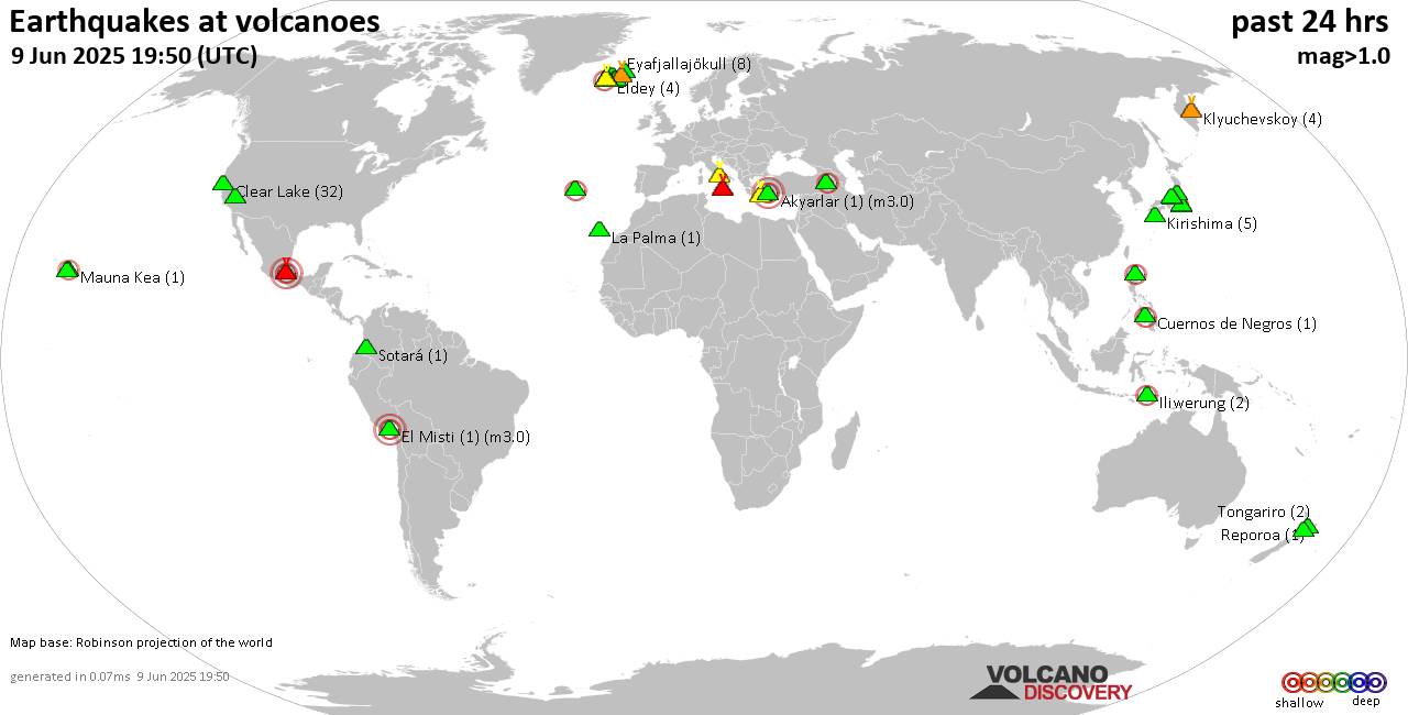 World map showing volcanoes with shallow (less than 50 km) earthquakes within 20 km radius during the past 24 hours on 9 Jun 2025 Number in brackets indicate nr of quakes. Quakes detected near: Akyarlar (1 quake mag 3.0), Apaneca Range (1 quake mag 2.1), Campi Flegrei (Phlegrean Fields) (13 quakes between mag 0.1-1.6), Clear Lake (32 quakes between mag 0.2-1.3), Cuernos de Negros (1 quake mag 2.2), El Misti (1 quake mag 3.0)
Eldey (4 quakes between mag 1.3-2.2), Etna (3 quakes between mag 0.9-1.4), Eyafjallajökull (8 quakes between mag 0.1-1.0), Furnas (20 quakes between mag 2.0-3.1), Hiuchi (8 quakes between mag 0.1-1.8), Hrómundartindur (6 quakes between mag 0.2-1.1), Iliwerung (2 quakes between mag 2.5-2.6), Kirishima (8 quakes between mag 0.1-1.1), Klyuchevskoy (12 quakes between mag 0.7-2.0), Kolumbo (11 quakes between mag 1.1-3.7), Kozushima (2 quakes between mag 1.3-1.5), Krísuvík (6 quakes between mag 0.0-1.0), Kurikoma (3 quakes between mag 0.1-1.0), Ljósufjöll (7 quakes between mag 0.1-1.9), Ontake-san (3 quakes between mag 0.1-1.2), Poas (2 quakes between mag 0.9-1.1), Prestahnukur (2 quakes between mag 1.0-1.3), Ruapehu (2 quakes between mag 0.7-1.0), Salton Buttes (1 quake mag 1.0), Santorini (3 quakes between mag 0.4-1.0), Svartsengi (7 quakes between mag 0.0-1.1), Tendürek Dağ (1 quake mag 2.5), Theistareykjarbunga (1 quake mag 1.0), Tindfjallajökull (1 quake mag 1.0), Tjörnes Fracture Zone (1 quake mag 1.5), To-shima (30 quakes between mag 0.5-2.6), Tongariro (2 quakes between mag 0.7-1.3), Unzen (1 quake mag 1.6), Yake-dake (3 quakes between mag 0.2-1.2) (updated 13h50)
Note: Earthquakes within 20 km from and at depths less than 50 km under active volcanoes are reported. The list is not complete because many volcanoes are not monitored and/or seismic data in high resolution is not available publicly.
Volcanoes with recent earthquakes above magnitude 2 or more than 10 quakes are listed below:
Akyarlar volcano (Turkey): magnitude 3.0 earthquakeA magnitude 3.0 earthquake occurred at the volcano 17 hours ago. The quake, which might be volcanic in origin, was located at a depth of 10.00 km depth at 5 km distance WNW from the volcano. Earthquake details: Reported seismic-like event (likely no quake): 13 km north of Kos, Dodecanese, South Aegean, Greece, Jun 9, 2025 12:02 am (GMT +3) (5 km WNW) All earthquakes at AkyarlarApaneca Range volcano (El Salvador): magnitude 2.1 earthquakeA magnitude 2.1 earthquake occurred at the volcano 22 hours ago. The quake, which might be volcanic in origin, was located at a depth of 5.00 km depth at 4 km distance E from the volcano. Earthquake details: 2.1 quake 18 km north of Sonsonate, Departamento de Sonsonate, El Salvador, Jun 8, 2025 09:46 am (GMT -6) (4 km E) All earthquakes at Apaneca RangeCampi Flegrei (Phlegrean Fields) volcano (Italy): 13 earthquakes up to magnitude 1.6Possible earthquake swarm: 13 earthquakes occurred near (under) the volcano during 20 hours, the last being recorded quake 1 hour 8 minutes ago. Hypocenter depths ranged between 2.77 and 0.07 km. Earthquake details: (only 5 largest) 1.6 quake 2.5 km southeast of Pozzuoli, Napoli, Campania, Italy, Jun 9, 2025 01:19 am (GMT +2) (2 km W) 0.8 quake 3.6 km southeast of Pozzuoli, Napoli, Campania, Italy, Jun 9, 2025 04:36 am (GMT +2) (1 km WSW) 0.6 quake 3.7 km southeast of Pozzuoli, Napoli, Campania, Italy, Jun 9, 2025 04:39 am (GMT +2) (1 km W) 0.6 quake 2.6 km east of Pozzuoli, Napoli, Campania, Italy, Jun 9, 2025 12:07 pm (GMT +2) (2 km NW) 0.5 quake 3.8 km southeast of Pozzuoli, Napoli, Campania, Italy, Jun 9, 2025 04:48 am (GMT +2) (0 km W) All earthquakes at Campi Flegrei (Phlegrean Fields)Clear Lake volcano (California): 32 earthquakes up to magnitude 1.3Possible earthquake swarm: 32 earthquakes occurred near (under) the volcano during 22 hours, the last being recorded quake 1 hour 16 minutes ago. Hypocenter depths ranged between 7.79 and 0.19 km. Earthquake details: (only 5 largest) 1.3 quake Lake County, 28 mi north of Santa Rosa, Sonoma County, California, United States, Jun 8, 2025 05:47 pm (GMT -7) (15 km S) 1.3 quake 27 mi north of Santa Rosa, Sonoma County, California, United States, Jun 8, 2025 11:45 am (GMT -7) (17 km SSW) 1.2 quake 26 mi north of Santa Rosa, Sonoma County, California, United States, Jun 8, 2025 11:15 pm (GMT -7) (18 km S) 1.1 quake 25 mi north of Santa Rosa, Sonoma County, California, United States, Jun 8, 2025 06:40 pm (GMT -7) (19 km S) 1.1 quake 28 mi north of Santa Rosa, Sonoma County, California, United States, Jun 8, 2025 10:02 am (GMT -7) (16 km SSW) All earthquakes at Clear LakeCuernos de Negros volcano (Central Philippines): magnitude 2.2 earthquakeA magnitude 2.2 earthquake occurred at the volcano 1 hour 45 minutes ago. The quake, which might be volcanic in origin, was located at a depth of 4.00 km depth at 12 km distance S from the volcano. Earthquake details: 2.2 quake 25 km southwest of Dumaguete, Philippines, Jun 9, 2025 08:05 pm (GMT +8) (12 km S) All earthquakes at Cuernos de NegrosEl Misti volcano (Peru): magnitude 3.0 earthquakeA magnitude 3.0 earthquake occurred at the volcano 7 hours ago. The quake, which might be volcanic in origin, was located at a depth of 10.00 km depth at 16 km distance WSW from the volcano. Earthquake details: Reported seismic-like event (likely no quake): 4.4 km north of Arequipa, Arequipa, Peru, Jun 9, 2025 02:18 am (GMT -5) (16 km WSW) All earthquakes at El MistiEldey volcano (Iceland): 4 earthquakes up to magnitude 2.24 earthquakes occurred near (under) the volcano during 8 hours, the last being recorded quake 21 minutes ago. Hypocenter depths ranged between 13.70 and 8.50 km. Earthquake details: 2.2 quake Iceland: 1.2 km NNW of Geirfugladrangur Jun 9, 2025 12:42 pm (Reykjavik time) (15 km WSW) 2.0 quake 1.2 km NE of Geirfugladrangur Jun 9, 2025 12:27 pm (Universal Time) (14 km WSW) 2.0 quake Iceland: 5.0 km E of Geirfuglasker Jun 9, 2025 05:24 am (Reykjavik time) (7 km SW) 1.3 quake Iceland: 1.6 km SE of Geirfugladrangur Jun 9, 2025 01:29 pm (Reykjavik time) (15 km WSW) All earthquakes at EldeyEldey is located at the beginning of the Reykjanes Ridge off the SW tip of Iceland. Its highest elevation is the top of Eldey Island, but most of the volcanic edifice is submerged. Several eruptions occurred in historic times, last in 1926. Furnas volcano (Azores): 20 earthquakes up to magnitude 3.1Possible earthquake swarm: 20 earthquakes occurred near (under) the volcano during 20 hours, the last being recorded quake 1 hour 27 minutes ago. Hypocenter depths ranged between 15.00 and 1.00 km. Earthquake details: (only 5 largest) 3.1 quake North Atlantic Ocean, 28 km southeast of Ilha de Sao Miguel Island, Portugal, Jun 9, 2025 12:02 pm (Universal Time) (16 km SSE) 3.1 quake North Atlantic Ocean, 30 km southeast of Ilha de Sao Miguel Island, Portugal, Jun 9, 2025 05:54 am (Universal Time) (19 km SSE) 3.0 quake North Atlantic Ocean, 29 km southeast of Ilha de Sao Miguel Island, Portugal, Jun 9, 2025 10:55 am (Universal Time) (18 km SSE) 2.8 quake North Atlantic Ocean, 29 km southeast of Ilha de Sao Miguel Island, Portugal, Jun 9, 2025 03:49 am (Universal Time) (18 km SSE) 2.8 quake North Atlantic Ocean, 28 km southeast of Ilha de Sao Miguel Island, Portugal, Jun 8, 2025 03:57 pm (Universal Time) (17 km SSE) All earthquakes at FurnasIliwerung volcano (Lesser Sunda Islands): 2 earthquakes up to magnitude 2.62 earthquakes occurred near (under) the volcano during 45 minutes, the last being recorded quake 4 hours ago. Hypocenter depths ranged between 10.00 and 10.00 km. Earthquake details: 2.6 quake Kabupaten Lembata, 191 km north of Kupang, Indonesia, Jun 9, 2025 05:47 pm (GMT +8) (11 km NW) 2.5 quake Kabupaten Lembata, 189 km north of Kupang, Indonesia, Jun 9, 2025 05:03 pm (GMT +8) (9 km NW) All earthquakes at IliwerungKlyuchevskoy volcano (Central Kamchatka Depression): 12 earthquakes up to magnitude 2.0Possible earthquake swarm: 12 earthquakes occurred near (under) the volcano during 10 hours, the last being recorded quake 14 hours ago. Hypocenter depths ranged between 31.88 and 0.86 km. Earthquake details: (only 5 largest) 2.0 quake Ust'-Kamchatskiy Rayon, 32 km southwest of Klyuchi, Ust-Kamchatsky District, Kamchatka, Russia, Jun 9, 2025 07:44 am (Kamchatka time) (3 km WNW) 1.8 quake 30 km southwest of Klyuchi, Ust-Kamchatsky District, Kamchatka, Russia, Jun 9, 2025 03:04 am (Kamchatka time) (3 km NNW) 1.1 quake 33 km southwest of Klyuchi, Ust-Kamchatsky District, Kamchatka, Russia, Jun 9, 2025 07:54 am (Kamchatka time) (1 km SW) 1.0 quake 33 km southwest of Klyuchi, Ust-Kamchatsky District, Kamchatka, Russia, Jun 9, 2025 11:07 am (Kamchatka time) (1 km WSW) 1.0 quake 30 km southwest of Klyuchi, Ust-Kamchatsky District, Kamchatka, Russia, Jun 9, 2025 05:53 am (Kamchatka time) (3 km NNW) All earthquakes at KlyuchevskoyKolumbo volcano (Greece): 11 earthquakes up to magnitude 3.7Possible earthquake swarm: 11 earthquakes occurred near (under) the volcano during 23 hours, the last being recorded quake 1 hour 13 minutes ago. Hypocenter depths ranged between 22.89 and 5.00 km. Earthquake details: (only 5 largest) 3.7 quake Aegean Sea, 12 km north of Santorini Island, Greece, Jun 9, 2025 06:32 am (GMT +3) (1 km SSW) 1.9 quake Aegean Sea, 17 km south of Nisi Ios Island, Nomos Kykladon, South Aegean, Greece, Jun 9, 2025 03:36 pm (GMT +3) (18 km WNW) 1.9 quake Aegean Sea, 29 km northeast of Santorini Island, Greece, Jun 9, 2025 03:23 pm (GMT +3) (17 km NE) 1.9 quake Aegean Sea, 18 km northeast of Santorini Island, Greece, Jun 9, 2025 08:07 am (GMT +3) (9 km E) 1.8 quake Aegean Sea, 26 km northeast of Santorini Island, Greece, Jun 9, 2025 07:47 am (GMT +3) (15 km NE) All earthquakes at KolumboTendürek Dağ volcano (Turkey): magnitude 2.5 earthquakeA magnitude 2.5 earthquake occurred at the volcano 17 hours ago. The quake, which might be volcanic in origin, was located at a depth of 3.60 km depth at 18 km distance ENE from the volcano. Earthquake details: 2.5 quake 15 km south of Dogubayazit, Agri, Turkey, Jun 9, 2025 12:25 am (GMT +3:30) (18 km ENE) All earthquakes at Tendürek DağTo-shima volcano (Izu Islands): 30 earthquakes up to magnitude 2.6Possible earthquake swarm: 30 earthquakes occurred near (under) the volcano during 20 hours, the last being recorded quake 1 hour 34 minutes ago. Hypocenter depths ranged between 24.70 and 0.00 km. Earthquake details: (only 5 largest) 2.6 quake North Pacific Ocean, 31 km southeast of Shimoda, Shizuoka, Japan, Jun 9, 2025 05:28 am (GMT +9) (6 km W) 2.6 quake North Pacific Ocean, Tokyo, 46 km east of Shimoda, Shizuoka, Japan, Jun 9, 2025 03:11 am (GMT +9) (14 km ENE) 1.5 quake Philippine Sea, 29 km north of Kozu Shima Island, Tokyo, Japan, Jun 9, 2025 02:01 am (GMT +9) (7 km SSW) 1.5 quake North Pacific Ocean, Tokyo, 45 km east of Shimoda, Shizuoka, Japan, Jun 9, 2025 03:14 am (GMT +9) (13 km ENE) 1.4 quake North Pacific Ocean, Tokyo, 30 km southeast of Shimoda, Shizuoka, Japan, Jun 9, 2025 03:24 pm (GMT +9) (6 km W) All earthquakes at To-shimahttps://www.volcanodiscovery.com/earthquakes-volcanoes/news/273152/Volcano-earthquake-report-for-Monday-9-Jun-2025.html
|
|


CMS The Best Conveyancing solicitors conveyancing quotes throughout the UK
For any webhosting enquiries please email webmaster@aus-city.com
|
|
Entire Thread
|
 Volcano earthquake report for Monday, 9 Jun 2025
|
Webmaster
|
Mon 09 Jun 2025 01:50:PM
|
|
Forums60
Topics730,450
Posts765,066
Members2,958
| |
Most Online4,158
Jun 21st, 2024
|
|
|
|
|
Copyright 1996 - 2024 by David Cottle. Designed by David Bate Jr. All Rights Reserved.
By using this forum, the user agrees not to transfer any data or technical information received under the agreement, to any other entity without the express approval of the AUS-CITY Forum Admins and/or authors of individual posts (Forum Admins and DoD/USSPACECOM for the analysis of satellite tracking data).
Two-line elements (TLE) and all other satellite data presented and distributed via this forum and e-mail lists of AUS-CITY are distributed with permission from DoD/USSTRATCOM.

Reprise Hosting

|

|


 - Click image for larger picture.")


