|
|
|
0 members (),
413
guests, and
24
robots. |
|
Key:
Admin,
Global Mod,
Mod
|
|
S |
M |
T |
W |
T |
F |
S |
|
|
|
|
|
|
1
|
2
|
|
3
|
4
|
5
|
6
|
7
|
8
|
9
|
|
10
|
11
|
12
|
13
|
14
|
15
|
16
|
|
17
|
18
|
19
|
20
|
21
|
22
|
23
|
|
24
|
25
|
26
|
27
|
28
|
29
|
30
|
|
31
|
|
|
|
|
|
|
|
There are no members with birthdays on this day. |
|
|
Joined: Feb 2001
Posts: 381,904
Launch Director
|
OP

Launch Director
Joined: Feb 2001
Posts: 381,904 |
Volcano earthquake report for Saturday, 2 Aug 2025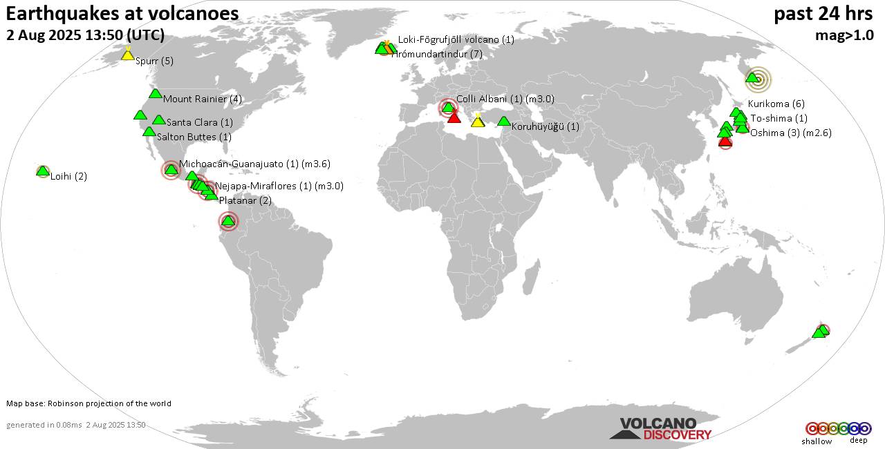 World map showing volcanoes with shallow (less than 50 km) earthquakes within 20 km radius during the past 24 hours on 2 Aug 2025 Number in brackets indicate nr of quakes. Quakes detected near: Agua (1 quake mag 3.1), Akuseki-jima (2 quakes between mag 2.0-2.5), Apaneca Range (10 quakes between mag 2.0-3.0), Apoyeque (2 quakes between mag 1.8-1.9), Askja (2 quakes between mag 0.5-1.4), Brennisteinsfjöll (2 quakes between mag 0.4-2.2)
Cerro Singüil (2 quakes between mag 2.0-2.5), Clear Lake (27 quakes between mag 0.2-1.6), Colli Albani (1 quake mag 3.0), El Chichón (1 quake mag 1.9), Eldey (4 quakes between mag 0.9-1.0), Etna (3 quakes between mag 1.1-2.1), Galeras (1 quake mag 3.0), Hekla (2 quakes between mag 0.8-1.2), Hiuchi (1 quake mag 1.3), Katla (4 quakes between mag 0.7-1.3), Kolumbo (4 quakes between mag 1.6-2.2), Koruhüyüğü (1 quake mag 1.1), Krísuvík (4 quakes between mag 0.2-1.9), Ksudach (1 quake mag 4.7), Kurikoma (4 quakes between mag 0.1-1.0), Loihi (2 quakes between mag 2.2-2.2), Loki-Fögrufjöll volcano (1 quake mag 1.4), Michoacán-Guanajuato (8 quakes between mag 2.2-3.6), Moffett (1 quake mag 1.8), Pacaya (1 quake mag 2.9), Platanar (3 quakes between mag 1.2-2.0), Prestahnukur (1 quake mag 1.9), Rotorua (14 quakes between mag 1.6-2.4), Ruapehu (1 quake mag 1.4), Salton Buttes (1 quake mag 1.5), Sanbe (4 quakes between mag 0.1-1.1), Santa Clara (3 quakes between mag 1.4-1.7), Santorini (2 quakes between mag 0.9-1.4), Spurr (1 quake mag 1.9), Sumaco (1 quake mag 1.7), To-shima (2 quakes between mag 1.0-1.6), Torfajökull (1 quake mag 1.2), Tsurumi (2 quakes between mag 0.3-1.6), Zao (2 quakes between mag 0.8-1.4) (updated 05h50)
Note: Earthquakes within 20 km from and at depths less than 50 km under active volcanoes are reported. The list is not complete because many volcanoes are not monitored and/or seismic data in high resolution is not available publicly.
Volcanoes with recent earthquakes above magnitude 2 or more than 10 quakes are listed below:
Agua volcano (Guatemala): magnitude 3.1 earthquakeA magnitude 3.1 earthquake occurred at the volcano 6 hours ago. The quake, which might be volcanic in origin, was located at a depth of 8.00 km depth at 11 km distance NE from the volcano. Earthquake details: 3.1 quake Departamento de Sacatepequez, 20 km southwest of Guatemala City, Guatemala, Aug 1, 2025 05:41 pm (GMT -6) (11 km NE) All earthquakes at AguaAkuseki-jima volcano (Ryukyu Islands): 2 earthquakes up to magnitude 2.52 earthquakes occurred near (under) the volcano during 1 hour 35 minutes, the last being recorded quake 11 hours ago. Hypocenter depths ranged between 0 and 0.00 km. Earthquake details: 2.5 quake East China Sea, Kagoshima-ken, 39 km south of Suwanose-jima Island, Japan, Aug 2, 2025 03:37 am (GMT +9) (19 km S) 2.0 quake East China Sea, Kagoshima-ken, 19 km southwest of Suwanose-jima Island, Japan, Aug 2, 2025 02:02 am (GMT +9) (4 km N) All earthquakes at Akuseki-jimaApaneca Range volcano (El Salvador): 10 earthquakes up to magnitude 3.010 earthquakes occurred near (under) the volcano during 20 hours, the last being recorded quake 3 hours ago. Hypocenter depths ranged between 13.00 and 3.00 km. Earthquake details: (only 5 largest) 3.0 quake EL Salvador Aug 1, 2025 01:01 am (GMT -6) (18 km NNW) 2.5 quake EL Salvador Aug 1, 2025 12:03 pm (GMT -6) (18 km NNW) 2.5 quake EL Salvador Aug 1, 2025 08:20 am (GMT -6) (18 km NNW) 2.5 quake 4.4 km north of Ahuachapan, Departamento de Ahuachapan, El Salvador, Aug 1, 2025 04:17 am (GMT -6) (10 km NW) 2.4 quake 12 km north of Ahuachapan, Departamento de Ahuachapan, El Salvador, Aug 1, 2025 02:38 am (GMT -6) (16 km NNW) All earthquakes at Apaneca RangeBrennisteinsfjöll volcano (Reykjanes Peninsula, Iceland): 2 earthquakes up to magnitude 2.22 earthquakes occurred near (under) the volcano during 53 minutes, the last being recorded quake 16 hours ago. Hypocenter depths ranged between 6.90 and 5.90 km. Earthquake details: 2.2 quake 5.2 km SSW of Bláfjallaskáli Aug 1, 2025 01:31 pm (Universal Time) (8 km ENE) 0.4 quake Iceland: 4.4 km W of Þorlákshöfn Aug 1, 2025 12:38 pm (Reykjavik time) (19 km ESE) All earthquakes at BrennisteinsfjöllCerro Singüil volcano (El Salvador): 2 earthquakes up to magnitude 2.52 earthquakes occurred near (under) the volcano during 22 hours, the last being recorded quake 1 hour 21 minutes ago. Hypocenter depths ranged between 5.00 and 5.00 km. Earthquake details: 2.5 quake El Salvador Aug 1, 2025 12:55 am (GMT -6) (16 km W) 2.0 quake 25 km south of Jutiapa, Departamento de Jutiapa, Guatemala, Aug 1, 2025 10:28 pm (GMT -6) (18 km W) All earthquakes at Cerro SingüilClear Lake volcano (California): 27 earthquakes up to magnitude 1.6Possible earthquake swarm: 27 earthquakes occurred near (under) the volcano during 23 hours, the last being recorded quake 50 minutes ago. Hypocenter depths ranged between 3.52 and 0.46 km. Earthquake details: (only 5 largest) 1.6 quake 28 mi north of Santa Rosa, Sonoma County, California, United States, Aug 1, 2025 10:44 am (GMT -7) (17 km SSW) 1.5 quake 27 mi north of Santa Rosa, Sonoma County, California, United States, Aug 1, 2025 03:15 pm (GMT -7) (18 km SSW) 1.3 quake 25 mi north of Santa Rosa, Sonoma County, California, United States, Aug 1, 2025 10:24 am (GMT -7) (19 km S) 1.2 quake 25 mi north of Santa Rosa, Sonoma County, California, United States, Aug 1, 2025 04:24 pm (GMT -7) (19 km S) 1.1 quake 25 mi north of Santa Rosa, Sonoma County, California, United States, Aug 1, 2025 06:34 pm (GMT -7) (19 km S) All earthquakes at Clear LakeColli Albani volcano (Italy): magnitude 3.0 earthquakeA magnitude 3.0 earthquake occurred at the volcano 9 hours ago. The quake, which might be volcanic in origin, was located at a depth of 10.00 km depth at 16 km distance NW from the volcano. Earthquake details: Reported seismic-like event (likely no quake): 6.9 km southeast of Rome, Citta metropolitana di Roma Capitale, Lazio, Italy, Aug 1, 2025 11:13 pm (GMT +2) (16 km NW) All earthquakes at Colli AlbaniEtna volcano (Italy): 3 earthquakes up to magnitude 2.13 earthquakes occurred near (under) the volcano during 5 hours, the last being recorded quake 4 hours ago. Hypocenter depths ranged between 21.33 and 11.78 km. Earthquake details: 2.1 quake 8 km north of Adrano, Catania, Sicily, Italy, Aug 2, 2025 04:03 am (GMT +2) (14 km W) 1.7 quake 8.2 km north of Adrano, Catania, Sicily, Italy, Aug 1, 2025 11:26 pm (GMT +2) (12 km W) 1.1 quake 5.7 km southeast of Bronte, Catania, Sicily, Italy, Aug 2, 2025 12:27 am (GMT +2) (11 km W) All earthquakes at EtnaGaleras volcano (Colombia): magnitude 3.0 earthquakeA magnitude 3.0 earthquake occurred at the volcano 13 hours ago. The quake, which might be volcanic in origin, was located at a depth of 10.00 km depth at 9 km distance E from the volcano. Earthquake details: Reported seismic-like event (likely no quake): 1.4 km northwest of Pasto, Departamento de Narino, Colombia, Aug 1, 2025 12:12 pm (GMT -5) (9 km E) All earthquakes at GalerasKolumbo volcano (Greece): 4 earthquakes up to magnitude 2.24 earthquakes occurred near (under) the volcano during 15 hours, the last being recorded quake 8 hours ago. Hypocenter depths ranged between 16.00 and 6.65 km. Earthquake details: 2.2 quake Aegean Sea, 26 km northeast of Santorini Island, Greece, Aug 1, 2025 07:27 pm (GMT +3) (15 km ENE) 2.2 quake Aegean Sea, 27 km northeast of Santorini Island, Greece, Aug 1, 2025 08:27 pm (GMT +3) (14 km NE) 1.7 quake Aegean Sea, 28 km southeast of Nisi Irakleia Island, Greece, Aug 1, 2025 09:26 am (GMT +3) (18 km NE) 1.6 quake Aegean Sea, 20 km northeast of Santorini Island, Greece, Aug 2, 2025 12:21 am (GMT +3) (8 km ENE) All earthquakes at KolumboKsudach volcano (Southern Kamchatka): magnitude 4.7 earthquakeA magnitude 4.7 earthquake occurred at the volcano 22 hours ago. The quake, which might be volcanic in origin, was located at a depth of 23.00 km depth at 14 km distance NNE from the volcano. Earthquake details: 4.7 quake Yelizovskiy Rayon, 145 km southwest of Petropavlovsk-Kamchatskiy, Kamchatka, Russia, Aug 1, 2025 08:07 pm (Kamchatka time) (14 km NNE) All earthquakes at KsudachLoihi volcano (Hawai'i (Big Island)): 2 earthquakes up to magnitude 2.22 earthquakes occurred near (under) the volcano during 3 hours, the last being recorded quake 10 hours ago. Hypocenter depths ranged between 34.21 and 32.95 km. Earthquake details: 2.2 quake North Pacific Ocean, 12 mi southeast of Pāhala, Hawaii County, Hawaii, United States, Aug 1, 2025 09:56 am (GMT -10) (19 km NW) 2.2 quake North Pacific Ocean, 12 mi southeast of Pāhala, Hawaii County, Hawaii, United States, Aug 1, 2025 06:52 am (GMT -10) (19 km NW) All earthquakes at LoihiMichoacán-Guanajuato volcano (Western & Central Mexico): 8 earthquakes up to magnitude 3.68 earthquakes occurred near (under) the volcano during 15 hours, the last being recorded quake 9 hours ago. Hypocenter depths ranged between 17.40 and 11.70 km. Earthquake details: (only 5 largest) 3.6 quake 31 km west of Uruapan, Estado de Michoacan de Ocampo, Mexico, Aug 1, 2025 03:01 pm (GMT -6) (15 km SW) 3.0 quake 33 km north of Apatzingan, Estado de Michoacan de Ocampo, Mexico, Aug 1, 2025 01:33 am (GMT -6) (19 km SW) 2.6 quake 33 km west of Uruapan, Estado de Michoacan de Ocampo, Mexico, Aug 1, 2025 01:28 am (GMT -6) (16 km SW) 2.5 quake 33 km north of Apatzingan, Estado de Michoacan de Ocampo, Mexico, Aug 1, 2025 05:51 am (GMT -6) (18 km SW) 2.5 quake 31 km west of Uruapan, Estado de Michoacan de Ocampo, Mexico, Aug 1, 2025 04:08 am (GMT -6) (14 km SW) All earthquakes at Michoacán-GuanajuatoPacaya volcano (Guatemala): magnitude 2.9 earthquakeA magnitude 2.9 earthquake occurred at the volcano 5 hours ago. The quake, which might be volcanic in origin, was located at a depth of 5.00 km depth at 13 km distance N from the volcano. Earthquake details: 2.9 quake 4.7 km southwest of Villa Nueva, Departamento de Guatemala, Guatemala, Aug 1, 2025 06:37 pm (GMT -6) (13 km N) All earthquakes at PacayaRotorua volcano (New Zealand): 14 earthquakes up to magnitude 2.4Possible earthquake swarm: 14 earthquakes occurred near (under) the volcano during 1 hour 36 minutes, the last being recorded quake 5 hours ago. Hypocenter depths ranged between 6.50 and 1.80 km. Earthquake details: (only 5 largest) 2.4 quake 1.4 km north of Rotorua, Bay of Plenty, New Zealand, Aug 2, 2025 12:05 pm (GMT +12) (6 km SSW) 2.4 quake 1.1 km northeast of Rotorua, Bay of Plenty, New Zealand, Aug 2, 2025 12:34 pm (GMT +12) (6 km SSW) 2.3 quake 0.8 km northeast of Rotorua, Bay of Plenty, New Zealand, Aug 2, 2025 01:08 pm (GMT +12) (6 km SSW) 2.2 quake 2.2 km northeast of Rotorua, Bay of Plenty, New Zealand, Aug 2, 2025 12:14 pm (GMT +12) (5 km SSW) 2.1 quake 1.5 km northeast of Rotorua, Bay of Plenty, New Zealand, Aug 2, 2025 12:24 pm (GMT +12) (6 km S) All earthquakes at RotoruaUnnamed 52.92°N/158.52°E volcano (Southern Kamchatka): magnitude 4.7 earthquakeA magnitude 4.7 earthquake occurred at the volcano 41 minutes ago. The quake, which might be volcanic in origin, was located at a depth of 35.00 km depth at 16 km distance ESE from the volcano. Earthquake details: 4.7 quake Yelizovskiy Rayon, 147 km southeast of Petropavlovsk-Kamchatskiy, Kamchatka, Russia, Aug 2, 2025 04:08 pm (GMT +11) (16 km ESE) All earthquakes at Unnamed 52.92°N/158.52°Ehttps://www.volcanodiscovery.com/earthquakes-volcanoes/news/277045/Volcano-earthquake-report-for-Saturday-2-Aug-2025.html
|
|


CMS The Best Conveyancing solicitors conveyancing quotes throughout the UK
For any webhosting enquiries please email webmaster@aus-city.com
|
|
Entire Thread
|

 Volcano earthquake report for Saturday, 2 Aug 2025
|
Webmaster
|
15 hours ago
|
|
Forums60
Topics733,465
Posts768,088
Members2,958
| |
Most Online4,158
Jun 21st, 2024
|
|
|
|
|
Copyright 1996 - 2024 by David Cottle. Designed by David Bate Jr. All Rights Reserved.
By using this forum, the user agrees not to transfer any data or technical information received under the agreement, to any other entity without the express approval of the AUS-CITY Forum Admins and/or authors of individual posts (Forum Admins and DoD/USSPACECOM for the analysis of satellite tracking data).
Two-line elements (TLE) and all other satellite data presented and distributed via this forum and e-mail lists of AUS-CITY are distributed with permission from DoD/USSTRATCOM.

Reprise Hosting

|

|


 - Click image for larger picture.")


