|
1 members (Alisa),
2,284
guests, and
33
robots. |
|
Key:
Admin,
Global Mod,
Mod
|
|
S |
M |
T |
W |
T |
F |
S |
|
|
|
|
1
|
2
|
3
|
4
|
|
5
|
6
|
7
|
8
|
9
|
10
|
11
|
|
12
|
13
|
14
|
15
|
16
|
17
|
18
|
|
19
|
20
|
21
|
22
|
23
|
24
|
25
|
|
26
|
27
|
28
|
29
|
30
|
31
|
|
|
There are no members with birthdays on this day. |
|
|
|
|
|
|
|
|
|
|
|
|
|
|
|
|
|
|
|
|
|
|
by Webmaster - Tue 14 Jul 2026 10:01:PM
|

Volcano earthquake report for Friday, 10 Jul 2026
• Moderate mag. 4.2 earthquake - 133 km northwest of Ternate, Kota Ternate, N...
• World Earthquake Report for Friday, 10 July 2026
• Moderate mag. 4.6 earthquake - 17 km southwest of Comalapa, Estado de Chiap...
• Moderate mag. 4.1 earthquake - Olyutorskiy Rayon, 47 km northwest of Tilich...
• Moderate mag. 4.0 earthquake - Hawke's Bay, New Zealand, on Saturday, Jul 1...
|

#781501
Sat 01 Nov 2025 10:30:PM
|
Joined: Feb 2001
Posts: 678,976
Launch Director
|
OP

Launch Director
Joined: Feb 2001
Posts: 678,976 |
SPC MD 2195MD 2195 CONCERNING SEVERE POTENTIAL...WATCH POSSIBLE FOR PARTS OF FAR SOUTHERN TEXAS INCLUDING THE MIDDLE AND LOWER COASTAL COUNTIES 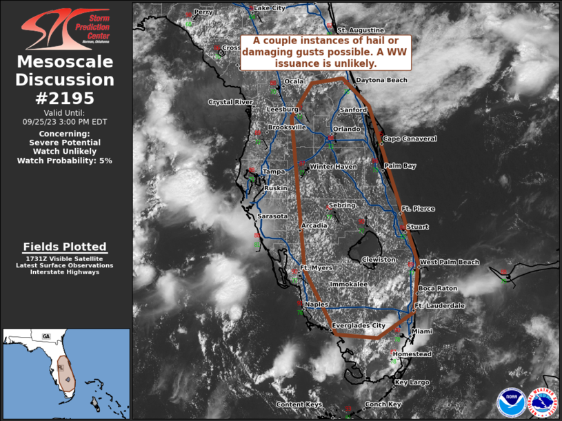
Mesoscale Discussion 2195
NWS Storm Prediction Center Norman OK
0523 PM CDT Sat Nov 01 2025

Areas affected...parts of far southern Texas including the middle
and lower coastal counties

Concerning...Severe potential...Watch possible

Valid 012223Z - 020130Z

Probability of Watch Issuance...40 percent

SUMMARY...Scattered storms, some severe, may develop over the next
several hours and affect much of the middle to lower Texas Coast. A
few storms may produce large and damaging hail.

DISCUSSION...Surface analysis shows an inverted trough from the
lower Rio Grande Valley into central TX, with significantly cooler
surface temperatures over central TX compared to far southern areas.
However, moist easterly low-level winds combined with cooling aloft
with the upper trough have supported elevated thunderstorms this
afternoon with minimal severe potential thus far.

Farther south, conditions appear to be much more favorable for large
hail, with full heating and a deepening moist boundary layer. The
primary uncertainty is storm coverage over land.

The 18Z CRP sounding showed a capping inversion near 800 mb. In
addition to gradual boundary layer moistening since then, 700 mb
temperatures have likely cooled as the upper trough digs
southeastward. Convection is already starting to increase across the
middle TX Coast, and this trend should continue. Cells may become
severe before moving offshore, with large hail the primary threat.
Deep-layer shear appears quite favorable with 50-60 kt effective
values.

At least isolated severe may occur later tonight toward the lower
Rio Grande, as midlevel temperatures continue to cool.

..Jewell/Mosier.. 11/01/2025

...Please see www.spc.noaa.gov for graphic product...

ATTN...WFO...HGX...CRP...EWX...BRO...

LAT...LON   25999786 27509860 28139872 29009794 29319646 29139538
            29009522 28269648 27829704 27119734 26589721 25949711
            25789744 25999786

MOST PROBABLE PEAK WIND GUST...UP TO 60 MPH
MOST PROBABLE PEAK HAIL SIZE...1.50-2.50 IN
Read morehttps://www.spc.noaa.gov/products/md/md2195.html
|
|


CMS The Best Conveyancing solicitors conveyancing quotes throughout the UK
For any webhosting enquiries please email webmaster@aus-city.com
|
|
Entire Thread
|
 SPC MD 2195
|
Webmaster
|
Sat 01 Nov 2025 10:30:PM
|
|
Forums60
Topics788,790
Posts823,565
Members2,960
| |
Most Online102,106
Jul 10th, 2026
|
|
|


 - Click image for larger picture.")


