|
|
|
0 members (),
3,110
guests, and
24
robots. |
|
Key:
Admin,
Global Mod,
Mod
|
|
S |
M |
T |
W |
T |
F |
S |
|
|
|
|
|
1
|
2
|
3
|
|
4
|
5
|
6
|
7
|
8
|
9
|
10
|
|
11
|
12
|
13
|
14
|
15
|
16
|
17
|
|
18
|
19
|
20
|
21
|
22
|
23
|
24
|
|
25
|
26
|
27
|
28
|
29
|
30
|
31
|
|
There are no members with birthdays on this day. |

#782542
Wed 05 Nov 2025 07:54:PM
|
Joined: Feb 2001
Posts: 381,904
Launch Director
|
OP

Launch Director
Joined: Feb 2001
Posts: 381,904 |
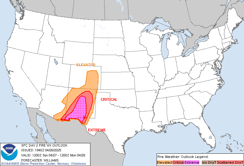
SPC Day 2 Fire Weather OutlookSPC Day 2 Fire Weather Outlook 
Day 2 Fire Weather Outlook
NWS Storm Prediction Center Norman OK
0153 PM CST Wed Nov 05 2025

Valid 061200Z - 071200Z

...Southern High Plains...
Enhanced mid-level westerly flow attributed to an approaching upper
short wave, along with expanding lee troughing across the
central/southern High Plains will promote stronger west to southwest
surface winds of 10-20 mph across eastern NM and much of the TX
Panhandle. Higher sustained wind speeds close to 20 mph are more
likely along the I-40 corridor in eastern NM. Elevated to locally
critical fire weather conditions are expected, although lack of very
dry fuels should attenuate overall fire spread potential across
eastern NM.

...Central High Plains...
Enhanced downslope winds are possible in the lee of the Rockies
across central/eastern CO on Thursday, amid stronger mid-level flow
moving over the Colorado Plateau. A drier and warmer air mass south
of a frontal boundary impinging into northern CO with relative
humidity as low as 10-15%, combined with west winds of 15 mph (20
mph in favored terrain gaps) is still anticipated to produce an
elevated fire weather threat Thursday.

...Mid-Mississippi Valley...
A dry return flow should become established across the
Mid-Mississippi Valley area Thursday as surface high pressure moves
into the Mid-Atlantic and deeper troughing becomes established
across the Great Plains. Increasing upper-level cloud cover should
limit mixing and a higher surface wind response as well as suppress
warming and RH reductions. Nonetheless, a locally elevated fire
weather threat should exist where south-southeast winds of up to 15
mph, relative humidity of around 25% and dry fuels align.

..Williams.. 11/05/2025

.PREV DISCUSSION... /ISSUED 1137 PM CST Tue Nov 04 2025/

...Synopsis...
For Thursday, a low-amplitude upper trough will move into the
central U.S. Another surface low will develop in the northern Plains
and bring a cold front south and east. Moderate to strong mid-level
winds will exist across the central Rockies along with a relatively
strong cross-Divide pressure gradient.

...Southern High Plains...
A deeper lee trough than on Wednesday and some mid-level flow
enhancement along the southern flank of a shortwave trough will
promote areas of 15-20 mph winds from eastern New Mexico into the
Texas Panhandle/South Plains. RH could fall below 15% in some areas,
but 15-20% will occur more broadly. Locally critical meteorological
conditions also appear possible; however, fuels are not sufficiently
dry to support more than an elevated fire weather threat.

...Central High Plains...
Stronger mid-level winds will flow across the central Rockies than
farther south. The strongest winds will likely be east of the
Laramie Range into parts of the Nebraska Panhandle. In eastern
Colorado, RH will be lower, but winds will be more modest outside of
the typically stronger gap winds. Elevated fire weather is most
probable where it will be warmer along the Front Range. Farther
north, a cooler airmass has recently moved into the area and it is
unclear if the airmass will modify enough to support sufficiently
low RH.

...Mid-Mississippi Valley...
As another surface high moves into the region on Wednesday, dry,
southerly return flow will again occur within the region.
Mid/upper-level clouds will again complicate the temperature
forecast and thus RH. However, it is possible that 25-30% could
occur at least locally. Dry fuels would support elevated fire
weather, but uncertainty in the occurrence/duration of these
conditions remains high.

...Please see www.spc.noaa.gov/fire for graphic product...
Read morehttps://www.spc.noaa.gov/products/fire_wx/fwdy2.html
|
|


CMS The Best Conveyancing solicitors conveyancing quotes throughout the UK
For any webhosting enquiries please email webmaster@aus-city.com
|
|
Entire Thread
|

 SPC Day 2 Fire Weather Outlook
|
Webmaster
|
Wed 05 Nov 2025 07:54:PM
|
|
Forums60
Topics758,805
Posts793,519
Members2,958
| |
Most Online17,963
Jan 15th, 2026
|
|
|
|
|
Copyright 1996 - 2026 by David Cottle. Designed by David Bate Jr. All Rights Reserved.
By using this forum, the user agrees not to transfer any data or technical information received under the agreement, to any other entity without the express approval of the AUS-CITY Forum Admins and/or authors of individual posts (Forum Admins and DoD/USSPACECOM for the analysis of satellite tracking data).
Two-line elements (TLE) and all other satellite data presented and distributed via this forum and e-mail lists of AUS-CITY are distributed with permission from DoD/USSTRATCOM.


Reprise Hosting


|

|