|
|
|
0 members (),
3,435
guests, and
26
robots. |
|
Key:
Admin,
Global Mod,
Mod
|
|
S |
M |
T |
W |
T |
F |
S |
|
|
|
|
|
1
|
2
|
3
|
|
4
|
5
|
6
|
7
|
8
|
9
|
10
|
|
11
|
12
|
13
|
14
|
15
|
16
|
17
|
|
18
|
19
|
20
|
21
|
22
|
23
|
24
|
|
25
|
26
|
27
|
28
|
29
|
30
|
31
|
|
There are no members with birthdays on this day. |

#792014
Fri 09 Jan 2026 11:50:PM
|
Joined: Feb 2001
Posts: 381,904
Launch Director
|
OP

Launch Director
Joined: Feb 2001
Posts: 381,904 |
Volcano earthquake report for Friday, 9 Jan 2026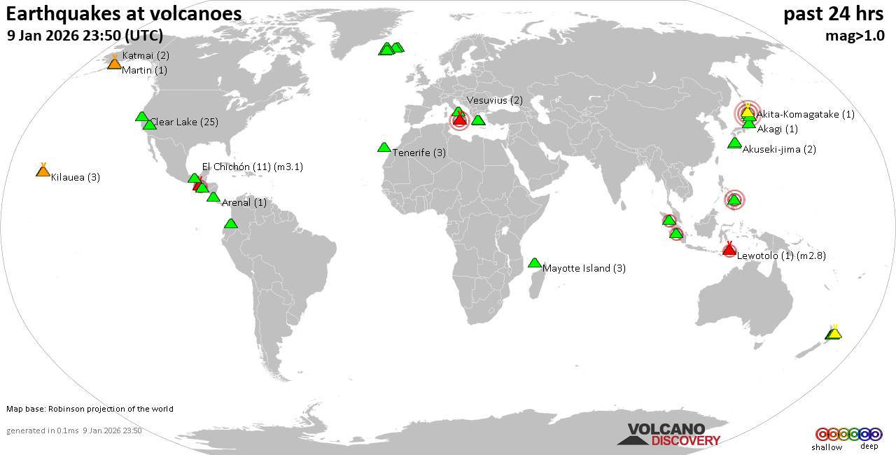 World map showing volcanoes with shallow (less than 50 km) earthquakes within 20 km radius during the past 24 hours on 9 Jan 2026 Number in brackets indicate nr of quakes. Quakes detected near: Agua (4 quakes between mag 1.9-3.3), Akagi (1 quake mag 1.2), Akita-Komagatake (1 quake mag 1.4), Akuseki-jima (2 quakes between mag 1.6-1.9), Apaneca Range (3 quakes between mag 1.8-3.3), Arenal (1 quake mag 1.9)
Askja (1 quake mag 1.7), Bardarbunga (5 quakes between mag 0.4-2.8), Brennisteinsfjöll (4 quakes between mag 0.6-1.3), Clear Lake (25 quakes between mag 0.6-1.7), Coso (3 quakes between mag 1.7-1.8), El Chichón (11 quakes between mag 1.8-3.1), Eldey (2 quakes between mag 1.7-2.2), Etna (3 quakes between mag 0.7-3.3), Fuego (1 quake mag 2.9), Galeras (2 quakes between mag 1.9-2.7), Hrómundartindur (2 quakes between mag 0.5-1.2), Katmai (2 quakes between mag 1.1-1.2), Kilauea (3 quakes between mag 1.6-1.9), Kuchinoshima (1 quake mag 1.2), Kurikoma (1 quake mag 1.3), Lewotolo (1 quake mag 2.8), Ljósufjöll (2 quakes between mag 0.7-1.4), Maroa (1 quake mag 1.9), Martin (1 quake mag 1.4), Maunaloa (1 quake mag 1.8), Mayotte Island (3 quakes between mag 0.8-1.4), Methana (1 quake mag 1.6), Paco (1 quake mag 3.0), Reporoa (1 quake mag 1.6), Rotorua (1 quake mag 2.4), Sousaki (1 quake mag 2.4), Sumbing (1 quake mag 2.3), Tenerife (3 quakes between mag 0.9-1.2), Toba (1 quake mag 2.0), Towada (3 quakes between mag 3.0-4.4), Vesuvius (2 quakes between mag 0.2-1.0), Whale Island (1 quake mag 1.8) (updated 23h50)
Note: Earthquakes within 20 km from and at depths less than 50 km under active volcanoes are reported. The list is not complete because many volcanoes are not monitored and/or seismic data in high resolution is not available publicly.
Volcanoes with recent earthquakes above magnitude 2 or more than 10 quakes are listed below:
Agua volcano (Guatemala): 4 earthquakes up to magnitude 3.34 earthquakes occurred near (under) the volcano during 14 hours, the last being recorded quake 7 hours ago. Hypocenter depths ranged between 7.00 and 3.00 km. Earthquake details: 3.3 quake Departamento de Sacatepequez, 25 km southwest of Guatemala City, Guatemala, Jan 9, 2026 01:14 am (GMT -6) (7 km ENE) 2.6 quake Departamento de Sacatepequez, 19 km southwest of Guatemala City, Guatemala, Jan 9, 2026 10:39 am (GMT -6) (12 km NE) 2.6 quake 4.9 km northeast of Palin, Departamento de Escuintla, Guatemala, Jan 8, 2026 08:24 pm (GMT -6) (8 km ESE) 1.9 quake 17 km southwest of Guatemala City, Departamento de Guatemala, Guatemala, Jan 9, 2026 01:20 am (GMT -6) (14 km NE) All earthquakes at AguaApaneca Range volcano (El Salvador): 3 earthquakes up to magnitude 3.33 earthquakes occurred near (under) the volcano during 4 hours, the last being recorded quake 4 hours ago. Hypocenter depths ranged between 10.00 and 4.30 km. Earthquake details: 3.3 quake 14 km north of Sonsonate, Departamento de Sonsonate, El Salvador, Jan 9, 2026 09:56 am (GMT -6) (7 km SSE) 2.1 quake 14 km north of Sonsonate, Departamento de Sonsonate, El Salvador, Jan 9, 2026 12:24 pm (GMT -6) (6 km SSE) 1.8 quake 15 km north of Sonsonate, Departamento de Sonsonate, El Salvador, Jan 9, 2026 02:13 pm (GMT -6) (5 km SE) All earthquakes at Apaneca RangeBardarbunga volcano (Iceland): 5 earthquakes up to magnitude 2.85 earthquakes occurred near (under) the volcano during 3 hours, the last being recorded quake 12 hours ago. Hypocenter depths ranged between 3.90 and 0.50 km. Earthquake details: 2.8 quake Northeast, 221 km east of Reykjavik, Capital Region, Iceland, Jan 9, 2026 09:47 am (Reykjavik time) (4 km E) 1.2 quake 3.8 km SW of Bárðarbunga Jan 9, 2026 09:15 am (Universal Time) (3 km SW) 0.8 quake Iceland: 4.4 km NW of Bárðarbunga Jan 9, 2026 11:25 am (Reykjavik time) (5 km NNW) 0.5 quake Iceland: 2.7 km E of Bárðarbunga Jan 9, 2026 09:50 am (Reykjavik time) (3 km ENE) 0.4 quake Iceland: 3.8 km SE of Bárðarbunga Jan 9, 2026 11:52 am (Reykjavik time) (3 km SE) All earthquakes at BardarbungaClear Lake volcano (California): 25 earthquakes up to magnitude 1.7Possible earthquake swarm: 25 earthquakes occurred near (under) the volcano during 21 hours, the last being recorded quake 2 hours ago. Hypocenter depths ranged between 3.73 and 0.95 km. Earthquake details: (only 5 largest) 1.7 quake Sonoma County, 13 mi southwest of Clearlake, Lake County, California, United States, Jan 8, 2026 07:03 pm (GMT -8) (16 km SSW) 1.5 quake Sonoma County, 13 mi southwest of Clearlake, Lake County, California, United States, Jan 8, 2026 08:16 pm (GMT -8) (18 km S) 1.4 quake 27 mi north of Santa Rosa, Sonoma County, California, United States, Jan 8, 2026 06:41 pm (GMT -8) (16 km SSW) 1.4 quake 28 mi north of Santa Rosa, Sonoma County, California, United States, Jan 8, 2026 08:04 pm (GMT -8) (15 km SSW) 1.4 quake 27 mi north of Santa Rosa, Sonoma County, California, United States, Jan 9, 2026 12:08 am (GMT -8) (17 km SSW) All earthquakes at Clear LakeEl Chichón volcano (Southern Mexico): 11 earthquakes up to magnitude 3.1Possible earthquake swarm: 11 earthquakes occurred near (under) the volcano during 11 hours, the last being recorded quake 13 hours ago. Hypocenter depths ranged between 3.00 and 1.40 km. Earthquake details: (only 5 largest) 3.1 quake Estado de Chiapas, 37 km southwest of Teapa, Estado de Tabasco, Mexico, Jan 8, 2026 07:20 pm (GMT -6) (1 km W) 2.7 quake Estado de Chiapas, 37 km southwest of Teapa, Estado de Tabasco, Mexico, Jan 8, 2026 10:25 pm (GMT -6) (1 km NNW) 2.7 quake Estado de Chiapas, 37 km southwest of Teapa, Estado de Tabasco, Mexico, Jan 9, 2026 04:52 am (GMT -6) (1 km NNW) 2.5 quake Estado de Chiapas, 36 km southwest of Teapa, Estado de Tabasco, Mexico, Jan 9, 2026 01:18 am (GMT -6) (1 km N) 2.5 quake Estado de Chiapas, 36 km southwest of Teapa, Estado de Tabasco, Mexico, Jan 9, 2026 02:07 am (GMT -6) (1 km N) All earthquakes at El ChichónEldey volcano (Iceland): 2 earthquakes up to magnitude 2.22 earthquakes occurred near (under) the volcano during 62 seconds, the last being recorded quake 20 hours ago. Hypocenter depths ranged between 6.70 and 1.40 km. Earthquake details: 2.2 quake 11.4 km NNW of Eldey Jan 9, 2026 03:41 am (Universal Time) (12 km N) 1.7 quake 7.8 km W of Reykjanestá Jan 9, 2026 03:40 am (Universal Time) (11 km NE) All earthquakes at EldeyEldey is located at the beginning of the Reykjanes Ridge off the SW tip of Iceland. Its highest elevation is the top of Eldey Island, but most of the volcanic edifice is submerged. Several eruptions occurred in historic times, last in 1926. Etna volcano (Italy): 3 earthquakes up to magnitude 3.33 earthquakes occurred near (under) the volcano during 14 hours, the last being recorded quake 2 hours ago. Hypocenter depths ranged between 15.43 and 0.70 km. Earthquake details: 3.3 quake 7.7 km north of Adrano, Catania, Sicily, Italy, Jan 9, 2026 10:33 pm (GMT +1) (13 km W) 2.2 quake 7 km northwest of Adrano, Catania, Sicily, Italy, Jan 9, 2026 04:45 pm (GMT +1) (18 km WSW) 0.7 quake 30 km north of Catania, Catania, Sicily, Italy, Jan 9, 2026 08:05 am (GMT +1) (1 km NE) All earthquakes at EtnaFuego volcano (Guatemala): magnitude 2.9 earthquakeA magnitude 2.9 earthquake occurred at the volcano 7 hours ago. The quake, which might be volcanic in origin, was located at a depth of 1.00 km depth at 14 km distance S from the volcano. Earthquake details: 2.9 quake 12 km northwest of Escuintla, Departamento de Escuintla, Guatemala, Jan 9, 2026 10:50 am (GMT -6) (14 km S) All earthquakes at FuegoGaleras volcano (Colombia): 2 earthquakes up to magnitude 2.72 earthquakes occurred near (under) the volcano at nearly the same time (10:07 UTC). Hypocenter depths ranged between 11.00 and 9.00 km. Earthquake details: 2.7 quake 7.7 km north of Pasto, Departamento de Narino, Colombia, Jan 9, 2026 05:07 am (GMT -5) (10 km NE) 1.9 quake 7 km northwest of Pasto, Departamento de Narino, Colombia, Jan 9, 2026 05:07 am (GMT -5) (10 km NE) All earthquakes at GalerasLewotolo volcano (Lesser Sunda Islands): magnitude 2.8 earthquakeA magnitude 2.8 earthquake occurred at the volcano 2 hours ago. The quake, which might be volcanic in origin, was located at a depth of 5.00 km depth at 18 km distance WNW from the volcano. Earthquake details: 2.8 quake Banda Sea, 25 km northeast of Pulau Adonara Island, Indonesia, Jan 10, 2026 05:26 am (GMT +8) (18 km WNW) All earthquakes at LewotoloPaco volcano (Mindanao): magnitude 3.0 earthquakeA magnitude 3.0 earthquake occurred at the volcano 59 minutes ago. The quake, which might be volcanic in origin, was located at a depth of 10.00 km depth at 16 km distance N from the volcano. Earthquake details: Unconfirmed quake or seismic-like event reported: 7.8 km southeast of Surigao, Province of Surigao del Norte, Caraga, Philippines, Jan 10, 2026 06:51 am (GMT +8) (16 km N) All earthquakes at PacoRotorua volcano (New Zealand): magnitude 2.4 earthquakeA magnitude 2.4 earthquake occurred at the volcano 25 minutes ago. The quake, which might be volcanic in origin, was located at a depth of 32.00 km depth at 16 km distance NNE from the volcano. Earthquake details: 2.4 quake 23 km north of Rotorua, Bay of Plenty, New Zealand, Jan 10, 2026 12:24 pm (GMT +13) (16 km NNE) All earthquakes at RotoruaSousaki volcano (Greece): magnitude 2.4 earthquakeA magnitude 2.4 earthquake occurred at the volcano 24 hours ago. The quake, which might be volcanic in origin, was located at a depth of 10.00 km depth at 13 km distance SW from the volcano. Earthquake details: 2.4 quake 12 km southeast of Corinth, Nomos Korinthias, Peloponnese, Greece, Jan 9, 2026 02:03 am (GMT +2) (13 km SW) All earthquakes at SousakiSumbing volcano (Sumatra): magnitude 2.3 earthquakeA magnitude 2.3 earthquake occurred at the volcano 52 minutes ago. The quake, which might be volcanic in origin, was located at a depth of 4.00 km depth at 3 km distance N from the volcano. Earthquake details: 2.3 quake Kabupaten Merangin, 53 km southeast of Sungai Penuh, Indonesia, Jan 10, 2026 05:57 am (GMT +7) (3 km N) All earthquakes at SumbingTowada volcano (Honshu): 3 earthquakes up to magnitude 4.43 earthquakes occurred near (under) the volcano during 1 hour 0 minutes, the last being recorded quake 12 hours ago. Hypocenter depths ranged between 10.00 and 10.00 km. Earthquake details: 4.4 quake 20 km north of Hanawa, Akita, Japan, Jan 9, 2026 08:24 pm (GMT +9) (18 km SSW) 4.0 quake 16 km northeast of Hanawa, Akita, Japan, Jan 9, 2026 08:35 pm (GMT +9) (19 km S) 3.0 quake 16 km northeast of Hanawa, Akita, Japan, Jan 9, 2026 07:35 pm (GMT +9) (19 km S) All earthquakes at Towadahttps://www.volcanodiscovery.com/earthquakes-volcanoes/news/291453/Volcano-earthquake-report-for-Friday-9-Jan-2026.html
|
|


CMS The Best Conveyancing solicitors conveyancing quotes throughout the UK
For any webhosting enquiries please email webmaster@aus-city.com
|
|
Entire Thread
|
 Volcano earthquake report for Friday, 9 Jan 2026
|
Webmaster
|
Fri 09 Jan 2026 11:50:PM
|
|
Forums60
Topics758,803
Posts793,517
Members2,958
| |
Most Online17,963
Jan 15th, 2026
|
|
|
|
|
Copyright 1996 - 2026 by David Cottle. Designed by David Bate Jr. All Rights Reserved.
By using this forum, the user agrees not to transfer any data or technical information received under the agreement, to any other entity without the express approval of the AUS-CITY Forum Admins and/or authors of individual posts (Forum Admins and DoD/USSPACECOM for the analysis of satellite tracking data).
Two-line elements (TLE) and all other satellite data presented and distributed via this forum and e-mail lists of AUS-CITY are distributed with permission from DoD/USSTRATCOM.

Reprise Hosting

|

|


 - Click image for larger picture.")


