|
0 members (),
1,746
guests, and
31
robots. |
|
Key:
Admin,
Global Mod,
Mod
|
|
S |
M |
T |
W |
T |
F |
S |
|
|
|
|
1
|
2
|
3
|
4
|
|
5
|
6
|
7
|
8
|
9
|
10
|
11
|
|
12
|
13
|
14
|
15
|
16
|
17
|
18
|
|
19
|
20
|
21
|
22
|
23
|
24
|
25
|
|
26
|
27
|
28
|
29
|
30
|
31
|
|
|
There are no members with birthdays on this day. |

Volcano earthquake report for Friday, 10 Jul 2026
• Moderate mag. 4.2 earthquake - 133 km northwest of Ternate, Kota Ternate, N...
• World Earthquake Report for Friday, 10 July 2026
• Moderate mag. 4.6 earthquake - 17 km southwest of Comalapa, Estado de Chiap...
• Moderate mag. 4.1 earthquake - Olyutorskiy Rayon, 47 km northwest of Tilich...
• Moderate mag. 4.0 earthquake - Hawke's Bay, New Zealand, on Saturday, Jul 1...
|

#792018
Sat 10 Jan 2026 03:43:PM
|
Joined: Feb 2001
Posts: 678,976
Launch Director
|
OP

Launch Director
Joined: Feb 2001
Posts: 678,976 |
SPC Tornado Watch 3WW 3 TORNADO AL GA MS 100950Z - 101600Z 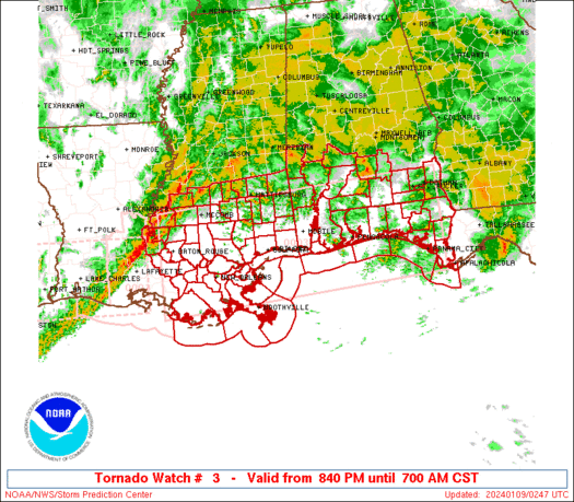
URGENT - IMMEDIATE BROADCAST REQUESTED
Tornado Watch Number 3
NWS Storm Prediction Center Norman OK
350 AM CST Sat Jan 10 2026

The NWS Storm Prediction Center has issued a

* Tornado Watch for portions of
  Central Alabama
  Northwest Georgia
  Southeast Mississippi

* Effective this Saturday morning from 350 AM until 1000 AM CST.

* Primary threats include...
  A few tornadoes possible
  Scattered damaging wind gusts to 70 mph possible

SUMMARY...Thunderstorms will increase in coverage and intensity
through the morning as an upper trough approaches.  Low-level shear
profiles will strengthen, posing a risk of a few supercells capable
of tornadoes and locally damaging wind gusts.

The tornado watch area is approximately along and 50 statute miles
north and south of a line from 10 miles northwest of Mc Comb MS to
30 miles east of Anniston AL. For a complete depiction of the watch
see the associated watch outline update (WOUS64 KWNS WOU3).

PRECAUTIONARY/PREPAREDNESS ACTIONS...

REMEMBER...A Tornado Watch means conditions are favorable for
tornadoes and severe thunderstorms in and close to the watch
area. Persons in these areas should be on the lookout for
threatening weather conditions and listen for later statements
and possible warnings.

&&

OTHER WATCH INFORMATION...CONTINUE...WW 2...

AVIATION...Tornadoes and a few severe thunderstorms with hail
surface and aloft to 0.5 inches. Extreme turbulence and surface wind
gusts to 60 knots. A few cumulonimbi with maximum tops to 500. Mean
storm motion vector 24035.

...Hart
Read morehttps://www.spc.noaa.gov/products/watch/ww0003.html
|
|


CMS The Best Conveyancing solicitors conveyancing quotes throughout the UK
For any webhosting enquiries please email webmaster@aus-city.com
|
|
Entire Thread
|
 SPC Tornado Watch 3
|
Webmaster
|
Sat 10 Jan 2026 03:43:PM
|
|
Forums60
Topics787,680
Posts822,454
Members2,960
| |
Most Online102,106
Yesterday at 06:57 PM
|
|
|


 - Click image for larger picture.")


