|
|
|
0 members (),
6,891
guests, and
26
robots. |
|
Key:
Admin,
Global Mod,
Mod
|
|
S |
M |
T |
W |
T |
F |
S |
|
|
|
|
|
1
|
2
|
3
|
|
4
|
5
|
6
|
7
|
8
|
9
|
10
|
|
11
|
12
|
13
|
14
|
15
|
16
|
17
|
|
18
|
19
|
20
|
21
|
22
|
23
|
24
|
|
25
|
26
|
27
|
28
|
29
|
30
|
31
|
|
There are no members with birthdays on this day. |
|
|
|
|
|
|
|
|
|
|
|
|
|
|
|
|
damn bruh
by Webmaster - Tue 27 Jan 2026 12:00:AM
|
|
|

#792931
Wed 14 Jan 2026 06:19:AM
|
Joined: Feb 2001
Posts: 381,904
Launch Director
|
OP

Launch Director
Joined: Feb 2001
Posts: 381,904 |
Moderate magnitude 4.5 quake hits 100 km northeast of Tiakur, Indonesia early afternoon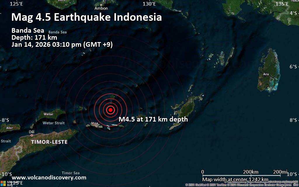 An intermediate to deep magnitude 4.5 earthquake was reported early afternoon near Tiakur, Southwest Maluku Regency, Maluku, Indonesia.
According to Indonesia's Meteorology, Climatology, and Geophysical Agency, the quake hit on Wednesday, January 14th, 2026, at 3:10 pm local time at an intermediate to considerable depth of 171. km. The strength of the earthquake may have been tempered by its relative great depth below the surface, which makes it feel weaker in absolute terms. The exact magnitude, epicenter, and depth of the quake might be revised within the next few hours or minutes as seismologists review data and refine their calculations, or as other agencies issue their report.
A second report was later issued by the citizen-seismograph network of RaspberryShake, which listed it as a magnitude 4.5 earthquake as well.
According to preliminary calculations, we do not expect that the quake was felt by many people and did not cause any damage. In Tiakur (pop. 5,200, 100 km away), the quake was probably not felt.
VolcanoDiscovery will automatically update magnitude and depth if these change and follow up if other significant news about the quake become available. If you’re in the area, please send us your experience through our reporting mechanism, either online or via our mobile app. This will help us provide more first-hand updates to anyone around the globe who wants to know more about this quake.
Earthquake data: Date & time: Jan 14, 2026 03:10 pm (GMT +9) local time (14 Jan 2026 06:10 GMT)Magnitude: 4.5 Depth: 171.00 km Epicenter latitude / longitude: 7.62°S / 128.53°E  (Southwest Maluku Regency, Maluku, Indonesia) Primary data source: BMKGhttps://www.volcanodiscovery.com/earthquake/news/291902/Moderate-magnitude-45-quake-hits-100-km-northeast-of-Tiakur-Indonesia-early-afternoon-.html
|
|


CMS The Best Conveyancing solicitors conveyancing quotes throughout the UK
For any webhosting enquiries please email webmaster@aus-city.com
|
|
Entire Thread
|
 Moderate magnitude 4.5 quake hits 100 km northeast of Tiakur, Indonesia early afternoon
|
Webmaster
|
Wed 14 Jan 2026 06:19:AM
|
|
Forums60
Topics758,991
Posts793,705
Members2,958
| |
Most Online17,963
Jan 15th, 2026
|
|
|
|
|
Copyright 1996 - 2026 by David Cottle. Designed by David Bate Jr. All Rights Reserved.
By using this forum, the user agrees not to transfer any data or technical information received under the agreement, to any other entity without the express approval of the AUS-CITY Forum Admins and/or authors of individual posts (Forum Admins and DoD/USSPACECOM for the analysis of satellite tracking data).
Two-line elements (TLE) and all other satellite data presented and distributed via this forum and e-mail lists of AUS-CITY are distributed with permission from DoD/USSTRATCOM.

Reprise Hosting

|

|


 - Click image for larger picture.")


