|
|
|
1 members (Webmaster),
2,308
guests, and
18
robots. |
|
Key:
Admin,
Global Mod,
Mod
|
|
S |
M |
T |
W |
T |
F |
S |
|
|
|
|
|
|
1
|
2
|
|
3
|
4
|
5
|
6
|
7
|
8
|
9
|
|
10
|
11
|
12
|
13
|
14
|
15
|
16
|
|
17
|
18
|
19
|
20
|
21
|
22
|
23
|
|
24
|
25
|
26
|
27
|
28
|
29
|
30
|
|
31
|
|
|
|
|
|
|
|
There are no members with birthdays on this day. |
|
|
|
|
|
|
|
|
|
|
by Webmaster - Wed 20 May 2026 12:27:AM
|
by Webmaster - Wed 20 May 2026 12:27:AM
|
by Webmaster - Wed 20 May 2026 12:27:AM
|
|
|
|
|

World Earthquake Report for Tuesday, 19 May 2026
• Volcano earthquake report for Tuesday, 19 May 2026
• Magnitude 5.2 earthquake strikes near Kahoku, Kahoku Shi, Ishikawa-ken, Jap...
• Moderate mag. 4.7 earthquake - Southern Iran on Tuesday, May 19, 2026, at 1...
• Strong mag. 5.2 earthquake - Sea of Japan or East Sea, 98 km northwest of K...
• Moderate mag. 4.5 earthquake - 25 km northwest of Takayama, Gifu, Japan, on...
|

#793100
Thu 15 Jan 2026 02:50:AM
|
Joined: Feb 2001
Posts: 381,904
Launch Director
|
OP

Launch Director
Joined: Feb 2001
Posts: 381,904 |
Volcano earthquake report for Thursday, 15 Jan 2026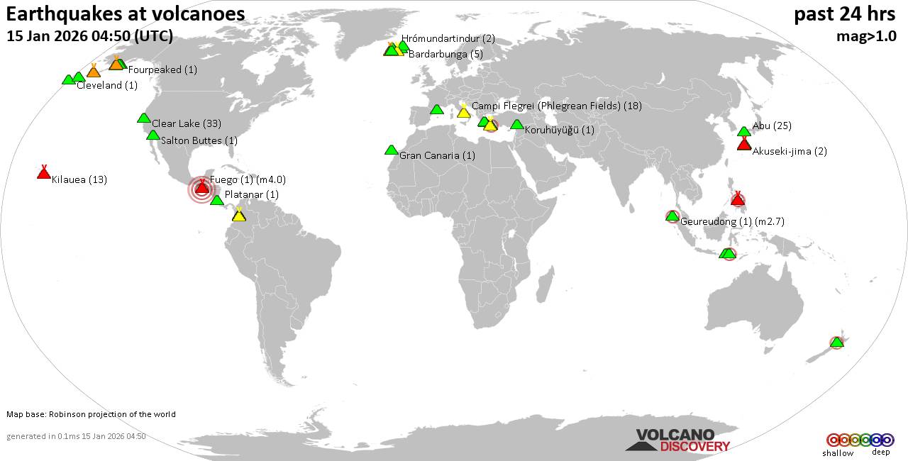 World map showing volcanoes with shallow (less than 50 km) earthquakes within 20 km radius during the past 24 hours on 15 Jan 2026 Number in brackets indicate nr of quakes. Quakes detected near: Abu (22 quakes between mag 0.3-1.0), Akuseki-jima (2 quakes between mag 1.1-1.7), Bardarbunga (4 quakes between mag 0.5-1.4), Campi Flegrei (Phlegrean Fields) (18 quakes between mag 0.1-2.5), Canlaon (10 quakes between mag 1.1-2.8), Cerro Bravo (1 quake mag 1.6)
Clear Lake (28 quakes between mag 0.2-1.5), Eldey (1 quake mag 1.7), Fourpeaked (1 quake mag 1.8), Fuego (1 quake mag 4.0), Geureudong (1 quake mag 2.7), Gilbanta (1 quake mag 2.1), Gran Canaria (1 quake mag 1.3), Hrómundartindur (2 quakes between mag 0.9-1.1), Ilopango (1 quake mag 3.0), Jan Mayen (1 quake mag 2.0), Kaguyak (1 quake mag 1.4), Katla (4 quakes between mag 0.8-1.8), Katmai (1 quake mag 1.0), Kilauea (13 quakes between mag 0.9-1.9), Kolumbo (1 quake mag 2.0), Koruhüyüğü (1 quake mag 1.4), Krísuvík (5 quakes between mag 0.3-1.7), Kuchinoshima (1 quake mag 1.4), Ljósufjöll (3 quakes between mag 0.6-1.0), Lokbatan (1 quake mag 3.0), Machin (2 quakes between mag 1.1-3.0), Martin (1 quake mag 1.7), Methana (2 quakes between mag 1.1-1.3), Nejapa-Miraflores (1 quake mag 1.8), Norikura (2 quakes between mag 0.8-2.1), Olot Field (1 quake mag 1.4), Pavlof (5 quakes between mag 0.0-1.0), Pavlof Sister (7 quakes between mag 0.0-1.0), Platanar (1 quake mag 1.8), Salton Buttes (1 quake mag 1.2), Santa Isabel (2 quakes between mag 0.0-1.0), Santorini (2 quakes between mag 1.1-3.2), Sousaki (3 quakes between mag 1.1-2.2), Taranaki (1 quake mag 2.0), Theistareykjarbunga (1 quake mag 1.1) (updated 02h50)
Note: Earthquakes within 20 km from and at depths less than 50 km under active volcanoes are reported. The list is not complete because many volcanoes are not monitored and/or seismic data in high resolution is not available publicly.
Volcanoes with recent earthquakes above magnitude 2 or more than 10 quakes are listed below:
Abu volcano (Honshu): 22 earthquakes up to magnitude 1.0Possible earthquake swarm: 22 earthquakes occurred near (under) the volcano during 15 hours, the last being recorded quake 7 hours ago. Hypocenter depths ranged between 35.40 and 28.80 km. Earthquake details: (only 5 largest) 1.0 quake 30 km north of Yamaguchi, Yamaguchi, Japan, Jan 15, 2026 03:22 am (GMT +9) (8 km S) 0.9 quake 30 km northeast of Yamaguchi, Yamaguchi, Japan, Jan 15, 2026 05:11 am (GMT +9) (8 km S) 0.8 quake 28 km northeast of Yamaguchi, Yamaguchi, Japan, Jan 14, 2026 07:23 pm (GMT +9) (10 km S) 0.8 quake 29 km northeast of Yamaguchi, Yamaguchi, Japan, Jan 14, 2026 06:32 pm (GMT +9) (9 km S) 0.8 quake 29 km northeast of Yamaguchi, Yamaguchi, Japan, Jan 14, 2026 05:43 pm (GMT +9) (9 km S) All earthquakes at AbuCampi Flegrei (Phlegrean Fields) volcano (Italy): 18 earthquakes up to magnitude 2.5Possible earthquake swarm: 18 earthquakes occurred near (under) the volcano during 21 hours, the last being recorded quake 1 hour 55 minutes ago. Hypocenter depths ranged between 3.69 and 0.94 km. Earthquake details: (only 5 largest) 2.5 quake 12 km west of Naples, Napoli, Campania, Italy, Jan 14, 2026 09:03 am (GMT +1) (1 km NW) 2.2 quake 3.4 km east of Pozzuoli, Napoli, Campania, Italy, Jan 14, 2026 09:03 am (GMT +1) (1 km NNW) 1.7 quake 2.6 km east of Pozzuoli, Napoli, Campania, Italy, Jan 14, 2026 09:13 am (GMT +1) (2 km NW) 0.8 quake 8.7 km southwest of Marano di Napoli, Napoli, Campania, Italy, Jan 14, 2026 03:25 pm (GMT +1) (1 km NW) 0.6 quake 4 km west of Fuorigrotta, Napoli, Campania, Italy, Jan 14, 2026 07:09 pm (GMT +1) (2 km ESE) All earthquakes at Campi Flegrei (Phlegrean Fields)Canlaon volcano (Central Philippines): 10 earthquakes up to magnitude 2.810 earthquakes occurred near (under) the volcano during 22 hours, the last being recorded quake 1 hour 40 minutes ago. Hypocenter depths ranged between 11.00 and 1.00 km. Earthquake details: (only 5 largest) 2.8 quake 17 km east of La Carlota, Philippines, Jan 15, 2026 08:04 am (GMT +8) (9 km NW) 2.2 quake 30 km southwest of Ualog, Philippines, Jan 15, 2026 09:10 am (GMT +8) (5 km N) 2.0 quake 22 km southeast of Mansilingan, Philippines, Jan 14, 2026 05:35 pm (GMT +8) (9 km WNW) 1.9 quake 22 km southeast of Mansilingan, Philippines, Jan 15, 2026 02:26 am (GMT +8) (8 km WNW) 1.8 quake 17 km east of La Carlota, Philippines, Jan 14, 2026 04:26 pm (GMT +8) (9 km NW) All earthquakes at CanlaonClear Lake volcano (California): 28 earthquakes up to magnitude 1.5Possible earthquake swarm: 28 earthquakes occurred near (under) the volcano during 20 hours, the last being recorded quake 2 hours ago. Hypocenter depths ranged between 3.27 and 0.39 km. Earthquake details: (only 5 largest) 1.5 quake 13 mi southwest of Clearlake, Lake County, California, United States, Jan 14, 2026 02:22 am (GMT -8) (14 km SSW) 1.4 quake 28 mi north of Santa Rosa, Sonoma County, California, United States, Jan 14, 2026 01:58 pm (GMT -8) (15 km SSW) 1.3 quake 28 mi north of Santa Rosa, Sonoma County, California, United States, Jan 14, 2026 10:09 am (GMT -8) (16 km SSW) 1.2 quake 26 mi north of Santa Rosa, Sonoma County, California, United States, Jan 14, 2026 03:26 am (GMT -8) (17 km S) 1.1 quake Lake County, 28 mi north of Santa Rosa, Sonoma County, California, United States, Jan 14, 2026 01:43 pm (GMT -8) (15 km S) All earthquakes at Clear LakeFuego volcano (Guatemala): magnitude 4.0 earthquakeA magnitude 4.0 earthquake occurred at the volcano 15 hours ago. The quake, which might be volcanic in origin, was located at a depth of 10.00 km depth at 17 km distance SW from the volcano. Earthquake details: 4.0 quake North Pacific Ocean, 33 km north of La Gomera, Guatemala, Jan 14, 2026 05:44 am (GMT -6) (17 km SW) All earthquakes at FuegoGeureudong volcano (Sumatra): magnitude 2.7 earthquakeA magnitude 2.7 earthquake occurred at the volcano 32 minutes ago. The quake, which might be volcanic in origin, was located at a depth of 3.00 km depth at 3 km distance W from the volcano. Earthquake details: 2.7 quake Kabupaten Bener Meriah, 61 km southwest of Lhokseumawe, Indonesia, Jan 15, 2026 09:18 am (GMT +7) (3 km W) All earthquakes at GeureudongGilbanta volcano (Lesser Sunda Islands): magnitude 2.1 earthquakeA magnitude 2.1 earthquake occurred at the volcano 11 hours ago. The quake, which might be volcanic in origin, was located at a depth of 7.00 km depth at 16 km distance E from the volcano. Earthquake details: 2.1 quake 48 km west of Labuan Bajo, Indonesia, Jan 15, 2026 12:13 am (GMT +8) (16 km E) All earthquakes at GilbantaIlopango volcano (El Salvador): magnitude 3.0 earthquakeA magnitude 3.0 earthquake occurred at the volcano 22 hours ago. The quake, which might be volcanic in origin, was located at a depth of 10.00 km depth at 13 km distance W from the volcano. Earthquake details: Reported seismic-like event (likely no quake): 1.3 km east of San Salvador, Departamento de San Salvador, El Salvador, Jan 13, 2026 10:26 pm (GMT -6) (13 km W) All earthquakes at IlopangoKilauea volcano (Hawai'i (Big Island)): 13 earthquakes up to magnitude 1.9Possible earthquake swarm: 13 earthquakes occurred near (under) the volcano during 17 hours, the last being recorded quake 5 hours ago. Hypocenter depths ranged between 29.27 and 0.46 km. Earthquake details: (only 5 largest) 1.9 quake 30 mi southwest of Hilo, Hawaii County, Hawaii, United States, Jan 14, 2026 12:09 pm (GMT -10) (7 km SSW) 1.9 quake 25 mi southwest of Hilo, Hawaii County, Hawaii, United States, Jan 13, 2026 07:17 pm (GMT -10) (1 km NNW) 1.9 quake 25 mi southwest of Hilo, Hawaii County, Hawaii, United States, Jan 13, 2026 07:13 pm (GMT -10) (2 km NNE) 1.8 quake 21 mi southwest of Hilo, Hawaii County, Hawaii, United States, Jan 14, 2026 09:35 am (GMT -10) (8 km NNE) 1.8 quake 22 mi southwest of Hilo, Hawaii County, Hawaii, United States, Jan 14, 2026 03:00 am (GMT -10) (6 km NNE) All earthquakes at KilaueaLokbatan volcano (Azerbaijan): magnitude 3.0 earthquakeA magnitude 3.0 earthquake occurred at the volcano 22 hours ago. The quake, which might be volcanic in origin, was located at a depth of 10.00 km depth at 7 km distance NNE from the volcano. Earthquake details: Reported seismic-like event (likely no quake): 5.5 km west of Baku, Baku City, Azerbaijan, Jan 14, 2026 04:49 am (GMT +0) (7 km NNE) All earthquakes at LokbatanMachin volcano (Colombia): 2 earthquakes up to magnitude 3.02 earthquakes occurred near (under) the volcano during 14 hours, the last being recorded quake 6 hours ago. Hypocenter depths ranged between 13.00 and 10.00 km. Earthquake details: Reported seismic-like event (likely no quake): 3.7 km northwest of Ibague, Departamento de Tolima, Colombia, Jan 14, 2026 01:35 am (GMT -5) (18 km E) 1.1 quake 10.6 km west of Ibague, Departamento de Tolima, Colombia, Jan 14, 2026 03:30 pm (GMT -5) (11 km E) All earthquakes at MachinNorikura volcano (Honshu): 2 earthquakes up to magnitude 2.12 earthquakes occurred near (under) the volcano during 24 minutes, the last being recorded quake 23 hours ago. Hypocenter depths ranged between 12.60 and 7.00 km. Earthquake details: 2.1 quake 22 km east of Takayama, Gifu, Japan, Jan 14, 2026 11:58 am (GMT +9) (6 km WSW) 0.8 quake 21 km east of Takayama, Gifu, Japan, Jan 14, 2026 12:22 pm (GMT +9) (7 km W) All earthquakes at NorikuraSantorini volcano (Greece): 2 earthquakes up to magnitude 3.22 earthquakes occurred near (under) the volcano during 12 hours, the last being recorded quake 6 hours ago. Hypocenter depths ranged between 9.30 and 4.80 km. Earthquake details: 3.2 quake Aegean Sea, 6.9 km east of Santorini Island, Greece, Jan 14, 2026 10:56 am (GMT +2) (12 km E) 1.1 quake Aegean Sea, 8 km east of Santorini Island, Nomos Kykladon, South Aegean, Greece, Jan 14, 2026 11:13 pm (GMT +2) (11 km E) All earthquakes at SantoriniSousaki volcano (Greece): 3 earthquakes up to magnitude 2.23 earthquakes occurred near (under) the volcano during 21 hours, the last being recorded quake 2 hours ago. Hypocenter depths ranged between 17.90 and 5.00 km. Earthquake details: 2.2 quake Aegean Sea, 13 km southeast of Corinth, Nomos Korinthias, Peloponnese, Greece, Jan 14, 2026 05:29 am (GMT +2) (9 km SSW) 1.9 quake Aegean Sea, 19 km southeast of Corinth, Nomos Korinthias, Peloponnese, Greece, Jan 15, 2026 02:27 am (GMT +2) (12 km SSE) 1.1 quake 21 km southeast of Corinth, Nomos Korinthias, Peloponnese, Greece, Jan 14, 2026 09:06 am (GMT +2) (13 km SSE) All earthquakes at Sousakihttps://www.volcanodiscovery.com/earthquakes-volcanoes/news/291941/Volcano-earthquake-report-for-Thursday-15-Jan-2026.html
|
|


CMS The Best Conveyancing solicitors conveyancing quotes throughout the UK
For any webhosting enquiries please email webmaster@aus-city.com
|
|
Entire Thread
|
 Volcano earthquake report for Thursday, 15 Jan 2026
|
Webmaster
|
Thu 15 Jan 2026 02:50:AM
|
|
Forums60
Topics775,535
Posts810,327
Members2,960
| |
Most Online22,463
May 9th, 2026
|
|
|
|
|
Copyright 1996 - 2026 by David Cottle. Designed by David Bate Jr. All Rights Reserved.
By using this forum, the user agrees not to transfer any data or technical information received under this agreement to any other entity without the express approval of the AUS-CITY Forum Admins and/or authors of individual posts (Forum Admins and DoD/USSPACECOM for the analysis of satellite tracking data).
Two-line elements (TLE) and all other satellite data presented and distributed via this forum and AUS-CITY mailing lists are distributed with permission from DoD/USSTRATCOM.

|

|


 - Click image for larger picture.")


