|
|
|
0 members (),
2,494
guests, and
26
robots. |
|
Key:
Admin,
Global Mod,
Mod
|
|
S |
M |
T |
W |
T |
F |
S |
|
|
|
|
|
|
1
|
2
|
|
3
|
4
|
5
|
6
|
7
|
8
|
9
|
|
10
|
11
|
12
|
13
|
14
|
15
|
16
|
|
17
|
18
|
19
|
20
|
21
|
22
|
23
|
|
24
|
25
|
26
|
27
|
28
|
29
|
30
|
|
31
|
|
|
|
|
|
|
|
There are no members with birthdays on this day. |

Volcano earthquake report for Saturday, 30 May 2026
• Light mag. 3.9 earthquake - 45 km northeast of Sitia, Lasithi, Crete, Greec...
• Moderate mag. 4.1 earthquake - Sea of Okhotsk, 53 km north of Shikotan Isla...
• Light mag. 3.9 earthquake - 304 km southwest of Yulara, Northern Territory,...
• Strong mag. 5.0 earthquake - South Atlantic Ocean, 18 km southeast of Brist...
• Moderate mag. 4.7 earthquake - Caribbean Sea, 73 km north of Gueiria, Sucre...
|

#793750
Mon 19 Jan 2026 01:50:AM
|
Joined: Feb 2001
Posts: 381,904
Launch Director
|
OP

Launch Director
Joined: Feb 2001
Posts: 381,904 |
Volcano earthquake report for Monday, 19 Jan 2026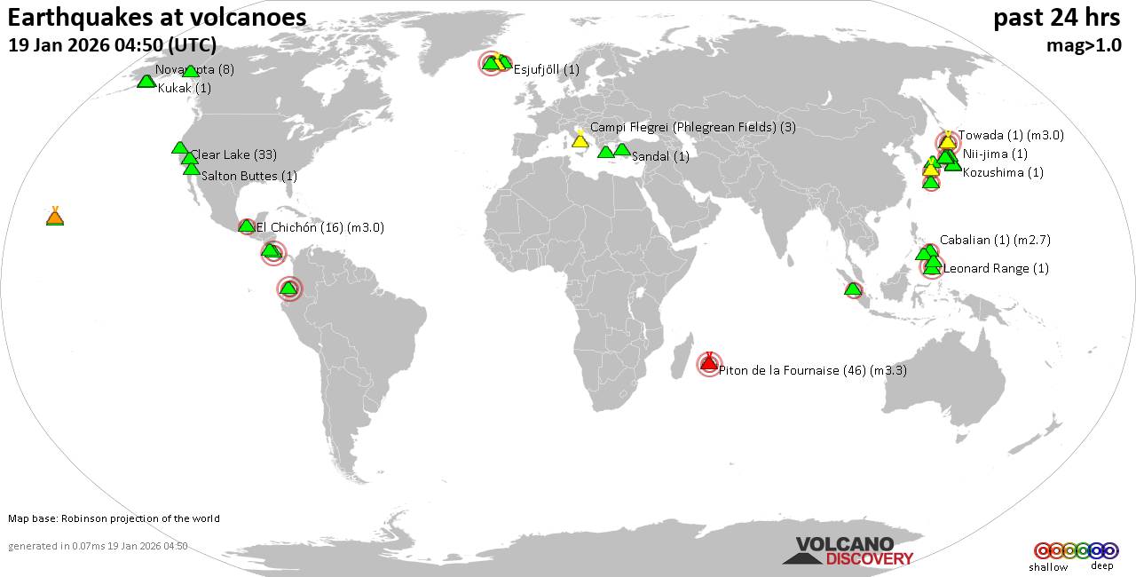 World map showing volcanoes with shallow (less than 50 km) earthquakes within 20 km radius during the past 24 hours on 19 Jan 2026 Number in brackets indicate nr of quakes. Quakes detected near: Abu (25 quakes between mag 0.1-1.2), Akuseki-jima (1 quake mag 2.1), Arenal (1 quake mag 1.9), Aso (6 quakes between mag 0.2-3.2), Balut (1 quake mag 3.0), Bardarbunga (2 quakes between mag 0.7-1.5)
Brennisteinsfjöll (1 quake mag 3.0), Cabalian (1 quake mag 2.7), Campi Flegrei (Phlegrean Fields) (3 quakes between mag 0.1-1.4), Churchill (1 quake mag 1.2), Clear Lake (30 quakes between mag 0.2-1.3), Coso (8 quakes between mag 0.7-1.5), Cuernos de Negros (1 quake mag 3.0), El Chichón (10 quakes between mag 2.2-2.9), Esjufjöll (1 quake mag 2.0), Guagua Pichincha (1 quake mag 3.0), Hiuchi (5 quakes between mag 0.1-1.4), Hrómundartindur (2 quakes between mag 0.8-1.1), Irazu (1 quake mag 3.0), Katla (1 quake mag 1.5), Katmai (2 quakes between mag 0.7-1.3), Kilauea (6 quakes between mag 1.7-1.9), Kukak (1 quake mag 1.1), Leonard Range (1 quake mag 1.8), Loihi (2 quakes between mag 1.7-2.2), Miravalles (1 quake mag 2.5), Myoko (39 quakes between mag 0.1-2.1), Nii-jima (1 quake mag 1.2), Norikura (7 quakes between mag 0.2-1.1), Novarupta (8 quakes between mag 0.6-1.2), Oshima (1 quake mag 1.0), Piton de la Fournaise (44 quakes between mag 0.0-3.3), Salton Buttes (1 quake mag 1.0), Sanbe (1 quake mag 3.0), Sandal (1 quake mag 1.3), Snowy Mountain (4 quakes between mag 0.9-2.3), Sousaki (1 quake mag 1.7), Tandikat (1 quake mag 2.1), Tenorio (1 quake mag 3.0), To-shima (1 quake mag 1.5), Torfajökull (2 quakes between mag 1.5-1.7), Towada (1 quake mag 3.0), Washiba-Kumonotaira (35 quakes between mag 0.1-1.9) (updated 01h50)
Note: Earthquakes within 20 km from and at depths less than 50 km under active volcanoes are reported. The list is not complete because many volcanoes are not monitored and/or seismic data in high resolution is not available publicly.
Volcanoes with recent earthquakes above magnitude 2 or more than 10 quakes are listed below:
Abu volcano (Honshu): 25 earthquakes up to magnitude 1.2Possible earthquake swarm: 25 earthquakes occurred near (under) the volcano during 20 hours, the last being recorded quake 1 hour 44 minutes ago. Hypocenter depths ranged between 33.20 and 28.70 km. Earthquake details: (only 5 largest) 1.2 quake 30 km north of Yamaguchi, Yamaguchi, Japan, Jan 18, 2026 12:54 pm (GMT +9) (7 km SSW) 0.9 quake 29 km north of Yamaguchi, Yamaguchi, Japan, Jan 18, 2026 03:50 pm (GMT +9) (8 km SSW) 0.8 quake 31 km north of Yamaguchi, Yamaguchi, Japan, Jan 19, 2026 07:41 am (GMT +9) (6 km S) 0.7 quake 30 km north of Yamaguchi, Yamaguchi, Japan, Jan 18, 2026 03:28 pm (GMT +9) (8 km S) 0.6 quake 29 km north of Yamaguchi, Yamaguchi, Japan, Jan 18, 2026 04:11 pm (GMT +9) (8 km S) All earthquakes at AbuAkuseki-jima volcano (Ryukyu Islands): magnitude 2.1 earthquakeA magnitude 2.1 earthquake occurred at the volcano 18 hours ago. The quake, which might be volcanic in origin, was located at a depth of 10.30 km depth at 14 km distance SSW from the volcano. Earthquake details: 2.1 quake East China Sea, Kagoshima-ken, 36 km southwest of Suwanose-jima Island, Japan, Jan 18, 2026 05:15 pm (GMT +9) (14 km SSW) All earthquakes at Akuseki-jimaAso volcano (Kyushu): 6 earthquakes up to magnitude 3.26 earthquakes occurred near (under) the volcano during 17 hours, the last being recorded quake 1 hour 2 minutes ago. Hypocenter depths ranged between 10.40 and 7.30 km. Earthquake details: (only 5 largest) 3.2 quake 32 km northeast of Kumamoto, Kumamoto, Japan, Jan 19, 2026 09:47 am (GMT +9) (11 km WNW) 2.9 quake 7.5 km west of Aso, Kumamoto, Japan, Jan 19, 2026 09:47 am (GMT +9) (11 km WNW) 0.7 quake 44 km northeast of Kumamoto, Kumamoto, Japan, Jan 19, 2026 04:20 am (GMT +9) (14 km N) 0.5 quake 45 km northeast of Kumamoto, Kumamoto, Japan, Jan 19, 2026 03:33 am (GMT +9) (12 km N) 0.4 quake 44 km northeast of Kumamoto, Kumamoto, Japan, Jan 19, 2026 12:07 am (GMT +9) (12 km N) All earthquakes at AsoBalut volcano (Mindanao): magnitude 3.0 earthquakeA magnitude 3.0 earthquake occurred at the volcano 17 hours ago. The quake, which might be volcanic in origin, was located at a depth of 10.00 km depth at 2 km distance N from the volcano. Earthquake details: Reported quake or seismic-like event: 30 km east of General Santos, Philippines, Jan 18, 2026 05:04 pm (GMT +8) (2 km N) All earthquakes at BalutBrennisteinsfjöll volcano (Reykjanes Peninsula, Iceland): magnitude 3.0 earthquakeA magnitude 3.0 earthquake occurred at the volcano 2 hours ago. The quake, which might be volcanic in origin, was located at a depth of 10.00 km depth at 19 km distance NNW from the volcano. Earthquake details: Reported seismic-like event (likely no quake): 5.3 km south of Reykjavik, Capital Region, Iceland, Jan 18, 2026 11:43 pm (GMT +0) (19 km NNW) All earthquakes at BrennisteinsfjöllCabalian volcano (Central Philippines): magnitude 2.7 earthquakeA magnitude 2.7 earthquake occurred at the volcano 5 hours ago. The quake, which might be volcanic in origin, was located at a depth of 1.00 km depth at 11 km distance WNW from the volcano. Earthquake details: 2.7 quake 40 km northeast of Maasin, Philippines, Jan 19, 2026 04:52 am (GMT +8) (11 km WNW) All earthquakes at CabalianClear Lake volcano (California): 30 earthquakes up to magnitude 1.3Possible earthquake swarm: 30 earthquakes occurred near (under) the volcano during 23 hours, the last being recorded quake 43 minutes ago. Hypocenter depths ranged between 14.82 and 0.70 km. Earthquake details: (only 5 largest) 1.3 quake 28 mi north of Santa Rosa, Sonoma County, California, United States, Jan 18, 2026 07:59 am (GMT -8) (16 km SSW) 1.3 quake 28 mi north of Santa Rosa, Sonoma County, California, United States, Jan 17, 2026 10:49 pm (GMT -8) (16 km SSW) 1.2 quake 26 mi north of Santa Rosa, Sonoma County, California, United States, Jan 18, 2026 05:07 pm (GMT -8) (18 km S) 1.1 quake 27 mi north of Santa Rosa, Sonoma County, California, United States, Jan 18, 2026 01:30 am (GMT -8) (18 km SSW) 1.0 quake Lake County, 28 mi north of Santa Rosa, Sonoma County, California, United States, Jan 18, 2026 10:32 am (GMT -8) (15 km S) All earthquakes at Clear LakeCuernos de Negros volcano (Central Philippines): magnitude 3.0 earthquakeA magnitude 3.0 earthquake occurred at the volcano 8 hours ago. The quake, which might be volcanic in origin, was located at a depth of 10.00 km depth at 11 km distance SE from the volcano. Earthquake details: Reported seismic-like event (likely no quake): 16 km southwest of Dumaguete, Philippines, Jan 19, 2026 02:14 am (GMT +8) (11 km SE) All earthquakes at Cuernos de NegrosEl Chichón volcano (Southern Mexico): 10 earthquakes up to magnitude 2.910 earthquakes occurred near (under) the volcano during 10 hours, the last being recorded quake 8 hours ago. Hypocenter depths ranged between 3.70 and 1.30 km. Earthquake details: (only 5 largest) 2.9 quake Estado de Chiapas, 37 km southwest of Teapa, Estado de Tabasco, Mexico, Jan 18, 2026 11:44 am (GMT -6) (1 km WSW) 2.9 quake Estado de Chiapas, 47 km southwest of Teapa, Estado de Tabasco, Mexico, Jan 18, 2026 02:04 am (GMT -6) (11 km SSW) 2.9 quake Estado de Chiapas, 37 km southwest of Teapa, Estado de Tabasco, Mexico, Jan 18, 2026 02:46 am (GMT -6) (1 km WSW) 2.7 quake Estado de Chiapas, 36 km southwest of Teapa, Estado de Tabasco, Mexico, Jan 18, 2026 02:19 am (GMT -6) (1 km N) 2.6 quake Estado de Chiapas, 38 km southwest of Teapa, Estado de Tabasco, Mexico, Jan 18, 2026 02:54 am (GMT -6) (1 km SW) All earthquakes at El ChichónGuagua Pichincha volcano (Ecuador): magnitude 3.0 earthquakeA magnitude 3.0 earthquake occurred at the volcano 5 hours ago. The quake, which might be volcanic in origin, was located at a depth of 10.00 km depth at 11 km distance E from the volcano. Earthquake details: Reported seismic-like event (likely no quake): 6.6 km northeast of Quito, Provincia de Pichincha, Ecuador, Jan 18, 2026 03:34 pm (GMT -5) (11 km E) All earthquakes at Guagua PichinchaIrazu volcano (Costa Rica): magnitude 3.0 earthquakeA magnitude 3.0 earthquake occurred at the volcano 18 hours ago. The quake, which might be volcanic in origin, was located at a depth of 10.00 km depth at 18 km distance SSE from the volcano. Earthquake details: Reported seismic-like event (likely no quake): 7.4 km east of Paraiso, Provincia de Cartago, Costa Rica, Jan 18, 2026 01:23 am (GMT -6) (18 km SSE) All earthquakes at IrazuLoihi volcano (Hawai'i (Big Island)): 2 earthquakes up to magnitude 2.22 earthquakes occurred near (under) the volcano during 3 hours, the last being recorded quake 21 hours ago. Hypocenter depths ranged between 33.39 and 21.35 km. Earthquake details: 2.2 quake North Pacific Ocean, 15 mi southeast of Pāhala, Hawaii County, Hawaii, United States, Jan 17, 2026 04:19 pm (GMT -10) (14 km NW) 1.7 quake North Pacific Ocean, 41 mi southeast of of Hawai‘i Island, Hawaii County, Hawaii, United States, Jan 17, 2026 07:14 pm (GMT -10) (16 km NNW) All earthquakes at LoihiMiravalles volcano (Costa Rica): magnitude 2.5 earthquakeA magnitude 2.5 earthquake occurred at the volcano 23 hours ago. The quake, which might be volcanic in origin, was located at a depth of 9.00 km depth at 11 km distance SW from the volcano. Earthquake details: 2.5 quake 23 km east of Liberia, Provincia de Guanacaste, Costa Rica, Jan 17, 2026 09:14 pm (GMT -6) (11 km SW) All earthquakes at MiravallesMyoko volcano (Honshu): 39 earthquakes up to magnitude 2.1Possible earthquake swarm: 39 earthquakes occurred near (under) the volcano during 9 hours, the last being recorded quake 1 hour 59 minutes ago. Hypocenter depths ranged between 4.30 and 0.00 km. Earthquake details: (only 5 largest) 2.1 quake Niigata, 21 km northwest of Nagano, Nagano, Japan, Jan 19, 2026 02:58 am (GMT +9) (9 km SSW) 2.1 quake Niigata, 21 km northwest of Nagano, Nagano, Japan, Jan 19, 2026 01:00 am (GMT +9) (9 km SSW) 1.5 quake Niigata, 21 km northwest of Nagano, Nagano, Japan, Jan 19, 2026 02:58 am (GMT +9) (8 km SSW) 1.3 quake Niigata, 21 km northwest of Nagano, Nagano, Japan, Jan 19, 2026 08:00 am (GMT +9) (9 km SSW) 1.2 quake Niigata, 21 km northwest of Nagano, Nagano, Japan, Jan 19, 2026 08:10 am (GMT +9) (9 km SSW) All earthquakes at MyokoPiton de la Fournaise volcano (Indian Ocean): 44 earthquakes up to magnitude 3.3Possible earthquake swarm: 44 earthquakes occurred near (under) the volcano during 5 hours, the last being recorded quake 9 hours ago. Hypocenter depths ranged between 1.50 and 0.10 km. Earthquake details: (only 5 largest) 3.3 quake 49 km southeast of Saint-Denis, Reunion, Jan 18, 2026 06:39 pm (GMT +4) (1 km SSE) 1.6 quake 21 km east of Le Tampon, Reunion, Jan 18, 2026 06:18 pm (GMT +4) (1 km E) 1.4 quake 48 km southeast of Saint-Denis, Reunion, Jan 18, 2026 07:06 pm (GMT +4) (0 km N) 1.3 quake 48 km southeast of Saint-Denis, Reunion, Jan 18, 2026 04:56 pm (GMT +4) (1 km N) 1.2 quake 49 km southeast of Saint-Denis, Reunion, Jan 18, 2026 04:53 pm (GMT +4) (1 km NE) All earthquakes at Piton de la FournaiseSanbe volcano (Honshu): magnitude 3.0 earthquakeA magnitude 3.0 earthquake occurred at the volcano 19 hours ago. The quake, which might be volcanic in origin, was located at a depth of 10.00 km depth at 17 km distance ESE from the volcano. Earthquake details: Reported seismic-like event (likely no quake): 25 km east of Anan, Tokushima, Japan, Jan 18, 2026 04:19 pm (GMT +9) (17 km ESE) All earthquakes at SanbeSnowy Mountain volcano (Alaska Peninsula): 4 earthquakes up to magnitude 2.34 earthquakes occurred near (under) the volcano during 4 hours, the last being recorded quake 20 hours ago. Hypocenter depths ranged between 8.80 and 0.00 km. Earthquake details: 2.3 quake Lake and Peninsula Borough, 99 mi northwest of Kodiak, Kodiak Island Borough, Alaska, United States, Jan 17, 2026 04:56 pm (GMT -9) (13 km NW) 1.6 quake Lake and Peninsula Borough, 99 mi northwest of Kodiak, Kodiak Island Borough, Alaska, United States, Jan 17, 2026 05:00 pm (GMT -9) (15 km NW) 1.2 quake Lake and Peninsula Borough, 99 mi northwest of Kodiak, Kodiak Island Borough, Alaska, United States, Jan 17, 2026 08:41 pm (GMT -9) (14 km NW) 0.9 quake Lake and Peninsula Borough, 98 mi northwest of Kodiak, Kodiak Island Borough, Alaska, United States, Jan 17, 2026 05:23 pm (GMT -9) (11 km NW) All earthquakes at Snowy MountainTandikat volcano (Sumatra): magnitude 2.1 earthquakeA magnitude 2.1 earthquake occurred at the volcano 9 hours ago. The quake, which might be volcanic in origin, was located at a depth of 3.00 km depth at 13 km distance SE from the volcano. Earthquake details: 2.1 quake Kabupaten Tanah Datar, 4.9 km south of Padangpanjang, Indonesia, Jan 19, 2026 12:13 am (GMT +7) (13 km SE) All earthquakes at TandikatTenorio volcano (Costa Rica): magnitude 3.0 earthquakeA magnitude 3.0 earthquake occurred at the volcano 21 hours ago. The quake, which might be volcanic in origin, was located at a depth of 10.00 km depth at 6 km distance NW from the volcano. Earthquake details: Reported seismic-like event (likely no quake): 28 km south of San José, Provincia de Alajuela, Costa Rica, Jan 17, 2026 11:02 pm (GMT -6) (6 km NW) All earthquakes at TenorioTowada volcano (Honshu): magnitude 3.0 earthquakeA magnitude 3.0 earthquake occurred at the volcano 21 hours ago. The quake, which might be volcanic in origin, was located at a depth of 10.00 km depth at 5 km distance NNW from the volcano. Earthquake details: Reported seismic-like event (likely no quake): 39 km northeast of Odate, Akita, Japan, Jan 18, 2026 01:55 pm (GMT +9) (5 km NNW) All earthquakes at TowadaWashiba-Kumonotaira volcano (Honshu): 35 earthquakes up to magnitude 1.9Possible earthquake swarm: 35 earthquakes occurred near (under) the volcano during 20 hours, the last being recorded quake 2 hours ago. Hypocenter depths ranged between 8.10 and 0.00 km. Earthquake details: (only 5 largest) 1.9 quake 26 km west of Azumino, Nagano, Japan, Jan 18, 2026 10:23 pm (GMT +9) (5 km SSE) 1.7 quake 27 km northwest of Azumino, Nagano, Japan, Jan 18, 2026 08:41 pm (GMT +9) (3 km SE) 1.4 quake 23 km northwest of Azumino, Nagano, Japan, Jan 19, 2026 03:47 am (GMT +9) (6 km SE) 1.1 quake 25 km west of Azumino, Nagano, Japan, Jan 19, 2026 12:00 am (GMT +9) (5 km SSE) 0.9 quake 25 km northwest of Azumino, Nagano, Japan, Jan 19, 2026 01:45 am (GMT +9) (4 km SE) All earthquakes at Washiba-Kumonotairahttps://www.volcanodiscovery.com/earthquakes-volcanoes/news/292290/Volcano-earthquake-report-for-Monday-19-Jan-2026.html
|
|


CMS The Best Conveyancing solicitors conveyancing quotes throughout the UK
For any webhosting enquiries please email webmaster@aus-city.com
|
|
Entire Thread
|
 Volcano earthquake report for Monday, 19 Jan 2026
|
Webmaster
|
Mon 19 Jan 2026 01:50:AM
|
|
Forums60
Topics777,565
Posts812,368
Members2,960
| |
Most Online22,463
May 9th, 2026
|
|
|
|
|
Copyright 1996 - 2026 by David Cottle. Designed by David Bate Jr. All Rights Reserved.
By using this forum, the user agrees not to transfer any data or technical information received under this agreement to any other entity without the express approval of the AUS-CITY Forum Admins and/or authors of individual posts (Forum Admins and DoD/USSPACECOM for the analysis of satellite tracking data).
Two-line elements (TLE) and all other satellite data presented and distributed via this forum and AUS-CITY mailing lists are distributed with permission from DoD/USSTRATCOM.

|

|


 - Click image for larger picture.")


