|
|
|
0 members (),
995
guests, and
28
robots. |
|
Key:
Admin,
Global Mod,
Mod
|
|
S |
M |
T |
W |
T |
F |
S |
|
|
|
|
1
|
2
|
3
|
4
|
|
5
|
6
|
7
|
8
|
9
|
10
|
11
|
|
12
|
13
|
14
|
15
|
16
|
17
|
18
|
|
19
|
20
|
21
|
22
|
23
|
24
|
25
|
|
26
|
27
|
28
|
29
|
30
|
31
|
|
|
There are no members with birthdays on this day. |

Volcano earthquake report for Friday, 3 Jul 2026
• World Earthquake Report for Friday, 3 July 2026
• Light mag. 3.9 earthquake - South Pacific Ocean, 14 km southwest of Huasco,...
• Significant magnitude 5.5 earthquake 38 km northwest of Valparaiso, Chile
• Strong mag. 5.5 earthquake - South Pacific Ocean, 38 km north of Valparaiso...
• Strong mag. 5.3 earthquake - Balleny Islands Region on Saturday, Jul 4, 202...
|

#796358
Fri 30 Jan 2026 11:10:PM
|
Joined: Feb 2001
Posts: 678,976
Launch Director
|
OP

Launch Director
Joined: Feb 2001
Posts: 678,976 |
Magnitude 4.6 earthquake strikes near Lahat, Lahat Regency, Sumatera Selatan, Indonesia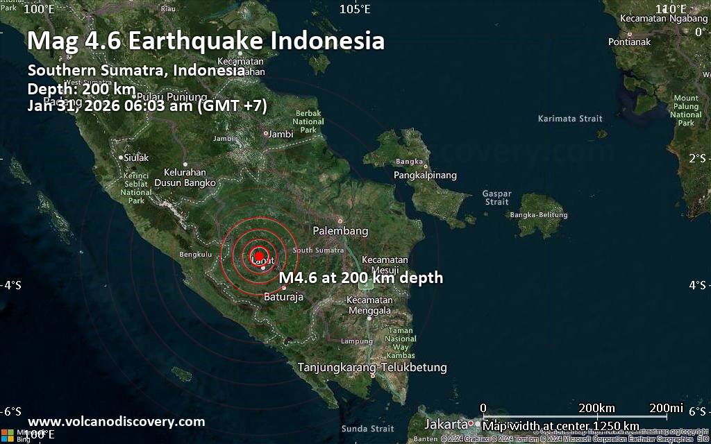 An earthquake of magnitude 4.6 occurred only 5 minutes ago 28 km northwest of Lahat, Indonesia, Indonesia's Meteorology, Climatology, and Geophysical Agency reported.
The quake hit at an intermediate to considerable depth of 200. km beneath the epicenter near Lahat, Lahat Regency, Sumatera Selatan, Indonesia, early morning on Saturday, January 31st, 2026, at 6:03 am local time. The exact magnitude, epicenter, and depth of the quake might be revised within the next few hours or minutes as seismologists review data and refine their calculations, or as other agencies issue their report.
A second report was later issued by the citizen-seismograph network of RaspberryShake, which listed it as a magnitude 4.8 earthquake.
Towns or cities near the epicenter where the quake might have been felt as very weak shaking include Lahat (pop. 65,900) located 28 km from the epicenter, Tanjungagung (pop. 53,100) 57 km away, Pagar Alam (pop. 70,400) 60 km away, Lubuklinggau (pop. 234,200) 74 km away, and Prabumulih (pop. 103,500) 84 km away. In Baturaja (pop. 134,800, 101 km away), the quake was probably not felt.
VolcanoDiscovery will automatically update magnitude and depth if these change and follow up if other significant news about the quake become available. If you’re in the area, please send us your experience through our reporting mechanism, either online or via our mobile app. This will help us provide more first-hand updates to anyone around the globe who wants to know more about this quake.
Earthquake data: Date & time: Jan 30, 2026 11:03 pm (Universal Time) local time (30 Jan 2026 23:03 GMT)Magnitude: 4.8 Depth: 233.00 km Epicenter latitude / longitude: 3.3°S / 103.73°E  ( Lahat Regency, Sumatera Selatan, Indonesia) Primary data source: BMKGhttps://www.volcanodiscovery.com/earthquake/news/293461/Magnitude-46-earthquake-strikes-near-Lahat-Lahat-Regency-Sumatera-Selatan-Indonesia.html
|
|


CMS The Best Conveyancing solicitors conveyancing quotes throughout the UK
For any webhosting enquiries please email webmaster@aus-city.com
|
|
Entire Thread
|
 Magnitude 4.6 earthquake strikes near Lahat, Lahat Regency, Sumatera Selatan, Indonesia
|
Webmaster
|
Fri 30 Jan 2026 11:10:PM
|
|
Forums60
Topics786,762
Posts821,534
Members2,960
| |
Most Online22,463
May 9th, 2026
|
|
|
|
|
Copyright 1996 - 2026 by David Cottle. Designed by David Bate Jr. All Rights Reserved.
By using this forum, the user agrees not to transfer any data or technical information received under this agreement to any other entity without the express approval of the AUS-CITY Forum Admins and/or authors of individual posts (Forum Admins and DoD/USSPACECOM for the analysis of satellite tracking data).
Two-line elements (TLE) and all other satellite data presented and distributed via this forum and AUS-CITY mailing lists are distributed with permission from DoD/USSTRATCOM.

|

|


 - Click image for larger picture.")


