|
|
|
1 members (Alisa),
775
guests, and
27
robots. |
|
Key:
Admin,
Global Mod,
Mod
|
|
S |
M |
T |
W |
T |
F |
S |
|
|
|
|
|
|
|
1
|
|
2
|
3
|
4
|
5
|
6
|
7
|
8
|
|
9
|
10
|
11
|
12
|
13
|
14
|
15
|
|
16
|
17
|
18
|
19
|
20
|
21
|
22
|
|
23
|
24
|
25
|
26
|
27
|
28
|
29
|
|
30
|
31
|
|
|
|
|
|
|
There are no members with birthdays on this day. |

Volcano earthquake report for Friday, 31 Jul 2026
• World Earthquake Report for Friday, 31 July 2026
• Light mag. 3.9 earthquake - Philippine Sea, 57 km east of Sulangan, Philipp...
• Small tremor of magnitude 3.1 just reported 10 km southwest of Naples, Ital...
• Seismic-like event, possible earthquake, reported few minutes ago near Napl...
• Strong mag. 5.0 earthquake - 65 km northeast of Pu'er, Yunnan Sheng, China,...
|

#797044
Fri 06 Feb 2026 05:50:AM
|
Joined: Feb 2001
Posts: 678,976
Launch Director
|
OP

Launch Director
Joined: Feb 2001
Posts: 678,976 |
Volcano earthquake report for Friday, 6 Feb 2026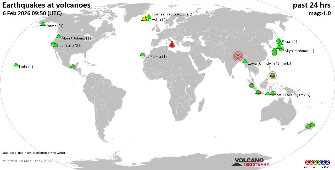 World map showing volcanoes with shallow (less than 50 km) earthquakes within 20 km radius during the past 24 hours on 6 Feb 2026 Number in brackets indicate nr of quakes. Quakes detected near: Akita-Yake-yama (7 quakes between mag 0.1-2.6), Askja (2 quakes between mag 0.1-1.2), Batu Tara (1 quake mag 2.6), Brennisteinsfjöll (2 quakes between mag 1.1-1.3), Campi Flegrei (Phlegrean Fields) (1 quake mag 1.2), Clear Lake (30 quakes between mag 0.2-2.0)
E-san (1 quake mag 1.3), El Chichón (9 quakes between mag 1.9-3.7), Eldey (1 quake mag 1.2), Hrómundartindur (14 quakes between mag 0.3-1.2), Ililabalekan (1 quake mag 2.5), Katla (11 quakes between mag 0.6-2.7), Katmai (3 quakes between mag 0.1-1.2), Komaga-take (1 quake mag 1.7), Krísuvík (9 quakes between mag 0.0-1.2), Kuchinoshima (1 quake mag 2.2), Kuju (3 quakes between mag 1.1-1.1), Kurikoma (6 quakes between mag 0.7-1.7), Ljósufjöll (6 quakes between mag 0.3-1.1), Loihi (1 quake mag 1.7), Long Valley (2 quakes between mag 0.4-1.0), Lower Chindwin (1 quake mag 4.4), Miyake-shima (1 quake mag 2.2), Mount Adams (2 quakes between mag 1.5-1.8), Ontake-san (4 quakes between mag 0.1-1.0), Prestahnukur (1 quake mag 1.0), Redoubt (1 quake mag 1.3), Sarik-Gajah (1 quake mag 2.3), Svartsengi (3 quakes between mag 0.6-1.2), Tambora (1 quake mag 2.4), Tandikat (1 quake mag 2.0), Tangkubanparahu (1 quake mag 2.8), Taranaki (1 quake mag 3.0), Tjörnes Fracture Zone (3 quakes between mag 0.2-1.9) (updated 05h50)
Note: Earthquakes within 20 km from and at depths less than 50 km under active volcanoes are reported. The list is not complete because many volcanoes are not monitored and/or seismic data in high resolution is not available publicly.
Volcanoes with recent earthquakes above magnitude 2 or more than 10 quakes are listed below:
Akita-Yake-yama volcano (Honshu): 7 earthquakes up to magnitude 2.67 earthquakes occurred near (under) the volcano during 15 hours, the last being recorded quake 7 hours ago. Hypocenter depths ranged between 12.60 and 3.40 km. Earthquake details: (only 5 largest) 2.6 quake 47 km northeast of Akita, Akita, Japan, Feb 5, 2026 04:43 pm (GMT +9) (19 km W) 2.6 quake 47 km northeast of Akita, Akita, Japan, Feb 5, 2026 04:43 pm (GMT +9) (19 km W) 1.6 quake 47 km northeast of Akita, Akita, Japan, Feb 5, 2026 04:46 pm (GMT +9) (19 km W) 1.3 quake 47 km northeast of Akita, Akita, Japan, Feb 6, 2026 08:05 am (GMT +9) (19 km W) 0.7 quake 47 km northeast of Akita, Akita, Japan, Feb 5, 2026 10:16 pm (GMT +9) (18 km W) All earthquakes at Akita-Yake-yamaBatu Tara volcano (Lesser Sunda Islands): magnitude 2.6 earthquakeA magnitude 2.6 earthquake occurred at the volcano 18 hours ago. The quake, which might be volcanic in origin, was located at a depth of 12.00 km depth at 8 km distance SSW from the volcano. Earthquake details: 2.6 quake Banda Sea, 60 km north of Lewoleba, Indonesia, Feb 5, 2026 08:10 pm (GMT +8) (8 km SSW) All earthquakes at Batu TaraClear Lake volcano (California): 30 earthquakes up to magnitude 2.0Possible earthquake swarm: 30 earthquakes occurred near (under) the volcano during 22 hours, the last being recorded quake 1 hour 17 minutes ago. Hypocenter depths ranged between 10.91 and 1.31 km. Earthquake details: (only 5 largest) 2.0 quake Sonoma County, 13 mi southwest of Clearlake, Lake County, California, United States, Feb 5, 2026 02:41 am (GMT -8) (16 km S) 1.4 quake Lake County, 27 mi north of Santa Rosa, Sonoma County, California, United States, Feb 5, 2026 12:55 am (GMT -8) (16 km S) 1.1 quake 26 mi north of Santa Rosa, Sonoma County, California, United States, Feb 5, 2026 08:36 am (GMT -8) (18 km SSW) 1.1 quake Lake County, 27 mi north of Santa Rosa, Sonoma County, California, United States, Feb 5, 2026 02:49 am (GMT -8) (16 km S) 1.0 quake Lake County, 26 mi north of Santa Rosa, Sonoma County, California, United States, Feb 5, 2026 05:51 pm (GMT -8) (17 km S) All earthquakes at Clear LakeEl Chichón volcano (Southern Mexico): 9 earthquakes up to magnitude 3.79 earthquakes occurred near (under) the volcano during 9 hours, the last being recorded quake 15 hours ago. Hypocenter depths ranged between 19.20 and 2.60 km. Earthquake details: (only 5 largest) 3.7 quake 64 km north of Tuxtla, Estado de Chiapas, Mexico, Feb 5, 2026 02:24 am (Merida time) (5 km SE) 2.8 quake Estado de Chiapas, 36 km southwest of Teapa, Estado de Tabasco, Mexico, Feb 5, 2026 09:06 am (GMT -6) (1 km N) 2.6 quake Estado de Chiapas, 37 km southwest of Teapa, Estado de Tabasco, Mexico, Feb 5, 2026 12:11 am (GMT -6) (2 km NNW) 2.4 quake Estado de Chiapas, 37 km southwest of Teapa, Estado de Tabasco, Mexico, Feb 5, 2026 02:37 am (GMT -6) (1 km NNW) 2.4 quake Estado de Chiapas, 36 km southwest of Teapa, Estado de Tabasco, Mexico, Feb 5, 2026 03:25 am (GMT -6) (1 km N) All earthquakes at El ChichónHrómundartindur volcano (Iceland): 14 earthquakes up to magnitude 1.2Possible earthquake swarm: 14 earthquakes occurred near (under) the volcano during 22 hours, the last being recorded quake 30 minutes ago. Hypocenter depths ranged between 8.40 and 2.60 km. Earthquake details: (only 5 largest) 1.2 quake 1.2 km WNW of Hveradalir Feb 6, 2026 05:19 am (Universal Time) (12 km WSW) 1.1 quake 4.1 km SE of Skálafell Feb 5, 2026 07:30 am (Universal Time) (12 km SSW) 1.0 quake Iceland: 0.7 km SW of Hellisheiðarvirkjun Feb 6, 2026 04:44 am (Reykjavik time) (11 km WSW) 0.9 quake 0.9 km ESE of Hellisheiðarvirkjun Feb 6, 2026 04:19 am (Universal Time) (10 km WSW) 0.8 quake Iceland: 0.6 km SW of Hveradalir Feb 6, 2026 04:17 am (Reykjavik time) (12 km WSW) All earthquakes at HrómundartindurIlilabalekan volcano (Lesser Sunda Islands): magnitude 2.5 earthquakeA magnitude 2.5 earthquake occurred at the volcano 22 hours ago. The quake, which might be volcanic in origin, was located at a depth of 17.00 km depth at 19 km distance SSE from the volcano. Earthquake details: 2.5 quake Savu Sea, 37 km south of Lewoleba, Indonesia, Feb 5, 2026 03:55 pm (GMT +8) (19 km SSE) All earthquakes at Ililabalekan Katla volcano (Iceland): 11 earthquakes up to magnitude 2.7Possible earthquake swarm: 11 earthquakes occurred near (under) the volcano during 15 hours, the last being recorded quake 6 hours ago. Hypocenter depths ranged between 5.60 and 0.00 km. Earthquake details: (only 5 largest) 2.7 quake Iceland: 2.2 km NNW of Hábunga Feb 5, 2026 06:28 pm (Reykjavik time) (5 km SW) 1.6 quake 5.9 km ENE of Goðabunga Feb 5, 2026 06:38 pm (Universal Time) (6 km NW) 1.4 quake 2.8 km SSW of Goðabunga Feb 5, 2026 09:04 am (Universal Time) (11 km W) 1.3 quake Iceland: 2.8 km SE of Goðabunga Feb 5, 2026 11:50 am (Reykjavik time) (7 km W) 1.1 quake Iceland: 5.7 km E of Goðabunga Feb 5, 2026 06:42 pm (Reykjavik time) (4 km W) All earthquakes at KatlaKuchinoshima volcano (Ryukyu Islands): magnitude 2.2 earthquakeA magnitude 2.2 earthquake occurred at the volcano 19 hours ago. The quake, which might be volcanic in origin, was located at a depth of 9.00 km depth at 7 km distance WSW from the volcano. Earthquake details: 2.2 quake East China Sea, 8.3 km north of Nakanoshima, Kagoshima-ken, Japan, Feb 5, 2026 07:22 pm (GMT +9) (7 km WSW) All earthquakes at KuchinoshimaLower Chindwin volcano (Myanmar): magnitude 4.4 earthquakeA magnitude 4.4 earthquake occurred at the volcano 9 hours ago. The quake, which might be volcanic in origin, was located at a depth of 10.00 km depth at 15 km distance NW from the volcano. Earthquake details: 4.4 quake Namchi, Sikkim, 25 km northwest of Darjiling, Darjiling, West Bengal, India, Feb 6, 2026 02:20 am (Kolkata time) (15 km NW) All earthquakes at Lower ChindwinMiyake-shima volcano (Izu Islands): magnitude 2.2 earthquakeA magnitude 2.2 earthquake occurred at the volcano 17 hours ago. The quake, which might be volcanic in origin, was located at a depth of 12.60 km depth at 15 km distance W from the volcano. Earthquake details: 2.2 quake Philippine Sea, 25 km southeast of Kozu Shima Island, Tokyo, Japan, Feb 5, 2026 10:06 pm (GMT +9) (15 km W) All earthquakes at Miyake-shimaSarik-Gajah volcano (Sumatra): magnitude 2.3 earthquakeA magnitude 2.3 earthquake occurred at the volcano 23 hours ago. The quake, which might be volcanic in origin, was located at a depth of 5.00 km depth at 12 km distance WNW from the volcano. Earthquake details: 2.3 quake Kabupaten Pasaman, 57 km northwest of Bukittinggi, Indonesia, Feb 5, 2026 01:31 pm (GMT +7) (12 km WNW) All earthquakes at Sarik-GajahTambora volcano (Sumbawa): magnitude 2.4 earthquakeA magnitude 2.4 earthquake occurred at the volcano 17 hours ago. The quake, which might be volcanic in origin, was located at a depth of 8.00 km depth at 16 km distance N from the volcano. Earthquake details: 2.4 quake Kabupaten Bima, 75 km northeast of Sumbawa Besar, Indonesia, Feb 5, 2026 08:56 pm (GMT +8) (16 km N) All earthquakes at TamboraTangkubanparahu volcano (West Java): magnitude 2.8 earthquakeA magnitude 2.8 earthquake occurred at the volcano 20 hours ago. The quake, which might be volcanic in origin, was located at a depth of 7.00 km depth at 17 km distance ENE from the volcano. Earthquake details: 2.8 quake 16 km south of Subang, Kabupaten Subang, Jawa Barat, Indonesia, Feb 5, 2026 04:54 pm (GMT +7) (17 km ENE) All earthquakes at TangkubanparahuTaranaki volcano (North Island): magnitude 3.0 earthquakeA magnitude 3.0 earthquake occurred at the volcano 3 hours ago. The quake, which might be volcanic in origin, was located at a depth of 10.00 km depth at 19 km distance ESE from the volcano. Earthquake details: Reported seismic-like event (likely no quake): 27 km north of Hawera, Taranaki, New Zealand, Feb 6, 2026 04:08 pm (GMT +13) (19 km ESE) All earthquakes at Taranakihttps://www.volcanodiscovery.com/earthquakes-volcanoes/news/294036/Volcano-earthquake-report-for-Friday-6-Feb-2026.html
|
|


CMS The Best Conveyancing solicitors conveyancing quotes throughout the UK
For any webhosting enquiries please email webmaster@aus-city.com
|
|
Entire Thread
|
 Volcano earthquake report for Friday, 6 Feb 2026
|
Webmaster
|
Fri 06 Feb 2026 05:50:AM
|
|
Forums60
Topics794,042
Posts828,828
Members2,960
| |
Most Online102,106
Jul 10th, 2026
|
|
|
|
|

|


 - Click image for larger picture.")


