|
|
|
0 members (),
1,597
guests, and
24
robots. |
|
Key:
Admin,
Global Mod,
Mod
|
|
S |
M |
T |
W |
T |
F |
S |
|
|
|
|
1
|
2
|
3
|
4
|
|
5
|
6
|
7
|
8
|
9
|
10
|
11
|
|
12
|
13
|
14
|
15
|
16
|
17
|
18
|
|
19
|
20
|
21
|
22
|
23
|
24
|
25
|
|
26
|
27
|
28
|
29
|
30
|
31
|
|
|
There are no members with birthdays on this day. |

Volcano earthquake report for Friday, 10 Jul 2026
• Moderate mag. 4.2 earthquake - 133 km northwest of Ternate, Kota Ternate, N...
• World Earthquake Report for Friday, 10 July 2026
• Moderate mag. 4.6 earthquake - 17 km southwest of Comalapa, Estado de Chiap...
• Moderate mag. 4.1 earthquake - Olyutorskiy Rayon, 47 km northwest of Tilich...
• Moderate mag. 4.0 earthquake - Hawke's Bay, New Zealand, on Saturday, Jul 1...
|

#797636
Mon 09 Feb 2026 02:37:PM
|
Joined: Feb 2001
Posts: 678,976
Launch Director
|
OP

Launch Director
Joined: Feb 2001
Posts: 678,976 |
Small magnitude 3.6 earthquake 30 miles southwest of Kalifornsky, Alaska, United States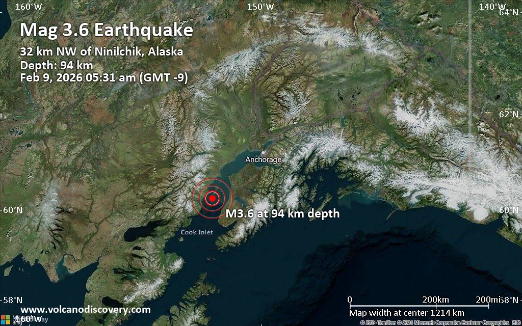 An earthquake of magnitude 3.6 occurred early morning on Monday, February 9th, 2026, at 5:31 am local time near Kalifornsky, Kenai Peninsula, Alaska, USA, as reported by the United States Geological Survey.
According to preliminary data, the quake was located at an intermediate depth of 58 miles. The exact magnitude, epicenter, and depth of the quake might be revised within the next few hours or minutes as seismologists review data and refine their calculations, or as other agencies issue their report.
Our monitoring service identified a second report from The Incorporated Research Institutions for Seismology (IRIS) which listed the quake at magnitude 3.6 as well. A third agency, the European-Mediterranean Seismological Centre (EMSC), reported the same quake at magnitude 3.6.
According to preliminary calculations, we do not expect that the quake was felt by many people and did not cause any damage. In Ninilchik (pop. 880, 20 miles away), Cohoe (pop. 1,400, 29 miles away), Kalifornsky (pop. 7,900, 30 miles away), Anchor Point (pop. 1,900, 34 miles away), Kenai (pop. 7,700, 36 miles away), Soldotna (pop. 4,500, 40 miles away), Ridgeway (pop. 2,000, 40 miles away), and Nikiski (pop. 4,500, 41 miles away), the quake was probably not felt.
Earthquake data: Date & time: Feb 9, 2026 05:31 am (GMT -9) local time (9 Feb 2026 14:31 GMT)Magnitude: 3.6 Depth: 93.90 km Epicenter latitude / longitude: 60.25°N / 152.11°W  (Kenai Peninsula, Alaska, United States) Primary data source: USGShttps://www.volcanodiscovery.com/earthquake/news/294377/Small-magnitude-36-earthquake-30-miles-southwest-of-Kalifornsky-Alaska-United-States.html
|
|


CMS The Best Conveyancing solicitors conveyancing quotes throughout the UK
For any webhosting enquiries please email webmaster@aus-city.com
|
|
Entire Thread
|
 Small magnitude 3.6 earthquake 30 miles southwest of Kalifornsky, Alaska, United States
|
Webmaster
|
Mon 09 Feb 2026 02:37:PM
|
|
Forums60
Topics788,481
Posts823,256
Members2,960
| |
Most Online102,106
Jul 10th, 2026
|
|
|
|
|
Copyright 1996 - 2026 by David Cottle. Designed by David Bate Jr. All Rights Reserved.
By using this forum, the user agrees not to transfer any data or technical information received under this agreement to any other entity without the express approval of the AUS-CITY Forum Admins and/or authors of individual posts (Forum Admins and DoD/USSPACECOM for the analysis of satellite tracking data).
Two-line elements (TLE) and all other satellite data presented and distributed via this forum and AUS-CITY mailing lists are distributed with permission from DoD/USSTRATCOM.

|

|


 - Click image for larger picture.")


