|
|
|
0 members (),
6,331
guests, and
27
robots. |
|
Key:
Admin,
Global Mod,
Mod
|
|
S |
M |
T |
W |
T |
F |
S |
|
1
|
2
|
3
|
4
|
5
|
6
|
7
|
|
8
|
9
|
10
|
11
|
12
|
13
|
14
|
|
15
|
16
|
17
|
18
|
19
|
20
|
21
|
|
22
|
23
|
24
|
25
|
26
|
27
|
28
|
|
There are no members with birthdays on this day. |
|
|
Joined: Feb 2001
Posts: 381,904
Launch Director
|
OP

Launch Director
Joined: Feb 2001
Posts: 381,904 |
Volcano earthquake report for Monday, 23 Feb 2026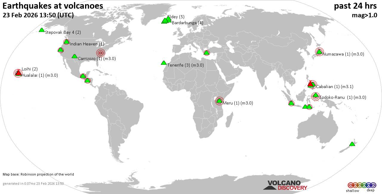 World map showing volcanoes with shallow (less than 50 km) earthquakes within 20 km radius during the past 24 hours on 23 Feb 2026 Number in brackets indicate nr of quakes. Quakes detected near: Bardarbunga (2 quakes between mag 0.9-1.0), Cabalian (1 quake mag 3.1), Campi Flegrei (Phlegrean Fields) (5 quakes between mag 0.1-1.7), Canlaon (3 quakes between mag 2.5-3.3), Carrizozo (1 quake mag 2.1), Clear Lake (26 quakes between mag 0.4-1.6)
El Chichón (9 quakes between mag 1.5-2.5), Eldey (2 quakes between mag 1.0-1.4), Gagak (1 quake mag 2.2), Geureudong (1 quake mag 2.2), Hrómundartindur (6 quakes between mag 0.0-1.0), Hualalai (1 quake mag 3.1), Hulubelu (1 quake mag 2.2), Indian Heaven (2 quakes between mag 1.2-2.2), Kilauea (6 quakes between mag 1.7-2.2), Kolbeinsey Ridge (1 quake mag 1.2), Kolumbo (2 quakes between mag 2.0-2.1), Licto (1 quake mag 3.0), Ljósufjöll (3 quakes between mag 0.6-1.4), Loihi (5 quakes between mag 1.7-2.0), Mammoth Mountain (1 quake mag 1.4), Mauna Kea (1 quake mag 2.0), Maunaloa (2 quakes between mag 2.1-2.5), Meru (1 quake mag 3.0), Numazawa (1 quake mag 3.0), Salton Buttes (1 quake mag 1.5), Stepovak Bay 4 (2 quakes between mag 1.3-1.5), Taranaki (1 quake mag 1.7), Tecapa (1 quake mag 2.2), Tenerife (4 quakes between mag 0.9-1.6) (updated 19h50)
Note: Earthquakes within 20 km from and at depths less than 50 km under active volcanoes are reported. The list is not complete because many volcanoes are not monitored and/or seismic data in high resolution is not available publicly.
Volcanoes with recent earthquakes above magnitude 2 or more than 10 quakes are listed below:
Cabalian volcano (Central Philippines): magnitude 3.1 earthquakeA magnitude 3.1 earthquake occurred at the volcano 8 hours ago. The quake, which might be volcanic in origin, was located at a depth of 3.00 km depth at 12 km distance WNW from the volcano. Earthquake details: 3.1 quake 14 km east of Sogod, Province of Southern Leyte, Eastern Visayas, Philippines, Feb 23, 2026 07:32 pm (GMT +8) (12 km WNW) All earthquakes at CabalianCanlaon volcano (Central Philippines): 3 earthquakes up to magnitude 3.33 earthquakes occurred near (under) the volcano during 11 hours, the last being recorded quake 10 hours ago. Hypocenter depths ranged between 11.00 and 9.00 km. Earthquake details: 3.3 quake 21 km southeast of Mansilingan, Philippines, Feb 23, 2026 07:06 am (GMT +8) (10 km NW) 3.2 quake 17 km east of La Carlota, Philippines, Feb 23, 2026 05:40 pm (GMT +8) (12 km NW) 2.5 quake 16 km east of La Carlota, Philippines, Feb 23, 2026 06:06 pm (GMT +8) (10 km NW) All earthquakes at CanlaonCarrizozo volcano (New Mexico): magnitude 2.1 earthquakeA magnitude 2.1 earthquake occurred at the volcano 19 hours ago. The quake, which might be volcanic in origin, was located at a depth of 8.19 km depth at 10 km distance ENE from the volcano. Earthquake details: 2.1 quake Grayson County, 9.1 mi southwest of Galax, City of Galax County, Virginia, United States, Feb 22, 2026 07:45 pm (GMT -5) (10 km ENE) All earthquakes at CarrizozoClear Lake volcano (California): 26 earthquakes up to magnitude 1.6Possible earthquake swarm: 26 earthquakes occurred near (under) the volcano during 23 hours, the last being recorded quake 1 hour 22 minutes ago. Hypocenter depths ranged between 3.31 and 0.31 km. Earthquake details: (only 5 largest) 1.6 quake Sonoma County, 13 mi southwest of Clearlake, Lake County, California, United States, Feb 23, 2026 08:02 am (GMT -8) (17 km S) 1.4 quake 26 mi north of Santa Rosa, Sonoma County, California, United States, Feb 22, 2026 11:52 pm (GMT -8) (18 km SSW) 1.3 quake 5 km WNW of the Geysers, CA, Feb 23, 2026 10:19 am (GMT -8) (19 km S) 1.3 quake 6 km NW of the Geysers, CA, Feb 22, 2026 10:37 pm (GMT -8) (18 km SSW) 1.1 quake 7 km NW of the Geysers, CA, Feb 22, 2026 11:56 am (GMT -8) (18 km SSW) All earthquakes at Clear LakeEl Chichón volcano (Southern Mexico): 9 earthquakes up to magnitude 2.59 earthquakes occurred near (under) the volcano during 15 hours, the last being recorded quake 9 hours ago. Hypocenter depths ranged between 3.00 and 3.00 km. Earthquake details: (only 5 largest) 2.5 quake Estado de Chiapas, 37 km southwest of Teapa, Estado de Tabasco, Mexico, Feb 22, 2026 03:28 pm (GMT -6) (1 km NNW) 2.3 quake Estado de Chiapas, 36 km southwest of Teapa, Estado de Tabasco, Mexico, Feb 22, 2026 02:12 pm (GMT -6) (1 km N) 2.2 quake Estado de Chiapas, 37 km southwest of Teapa, Estado de Tabasco, Mexico, Feb 22, 2026 02:18 pm (GMT -6) (1 km NNW) 2.1 quake Estado de Chiapas, 37 km southwest of Teapa, Estado de Tabasco, Mexico, Feb 23, 2026 04:51 am (GMT -6) (1 km NW) 1.9 quake Estado de Chiapas, 38 km southwest of Teapa, Estado de Tabasco, Mexico, Feb 22, 2026 07:33 pm (GMT -6) (1 km SW) All earthquakes at El ChichónGagak volcano (West Java): magnitude 2.2 earthquakeA magnitude 2.2 earthquake occurred at the volcano 6 hours ago. The quake, which might be volcanic in origin, was located at a depth of 6.00 km depth at 10 km distance WNW from the volcano. Earthquake details: 2.2 quake Bogor Regency, 32 km north of Pelabuhanratu, Indonesia, Feb 23, 2026 08:51 pm (GMT +7) (10 km WNW) All earthquakes at GagakGeureudong volcano (Sumatra): magnitude 2.2 earthquakeA magnitude 2.2 earthquake occurred at the volcano 6 hours ago. The quake, which might be volcanic in origin, was located at a depth of 10.00 km depth at 4 km distance SSW from the volcano. Earthquake details: 2.2 quake Kabupaten Bener Meriah, 53 km south of Bireun, Indonesia, Feb 23, 2026 08:48 pm (GMT +7) (4 km SSW) All earthquakes at GeureudongHualalai volcano (Hawai'i (Big Island)): magnitude 3.1 earthquakeA magnitude 3.1 earthquake occurred at the volcano 8 hours ago. The quake, which might be volcanic in origin, was located at a depth of 4.86 km depth at 15 km distance W from the volcano. Earthquake details: 3.1 quake North Pacific Ocean, 15 mi west of Kailua-Kona, Hawaii County, Hawaii, United States, Feb 23, 2026 01:53 am (GMT -10) (15 km W) All earthquakes at HualalaiHulubelu volcano (Sumatra): magnitude 2.2 earthquakeA magnitude 2.2 earthquake occurred at the volcano 7 hours ago. The quake, which might be volcanic in origin, was located at a depth of 6.00 km depth at 10 km distance SSE from the volcano. Earthquake details: 2.2 quake Kabupaten Tanggamus, 71 km west of Bandar Lampung, Indonesia, Feb 23, 2026 07:28 pm (GMT +7) (10 km SSE) All earthquakes at HulubeluIndian Heaven volcano (Washington State): 2 earthquakes up to magnitude 2.22 earthquakes occurred near (under) the volcano during 3 hours, the last being recorded quake 4 hours ago. Hypocenter depths ranged between 5.09 and 0.48 km. Earthquake details: 2.2 quake Skamania County, 30 mi east of Battle Ground, Clark County, Washington, United States, Feb 23, 2026 05:00 am (GMT -8) (9 km W) 1.2 quake Skamania County, Washington, 25 mi northwest of Hood River, Hood River County, Oregon, United States, Feb 23, 2026 07:55 am (GMT -8) (9 km W) All earthquakes at Indian HeavenKilauea volcano (Hawai'i (Big Island)): 6 earthquakes up to magnitude 2.26 earthquakes occurred near (under) the volcano during 17 hours, the last being recorded quake 6 hours ago. Hypocenter depths ranged between 37.57 and 8.31 km. Earthquake details: (only 5 largest) 2.2 quake 7.5 mi northeast of Pāhala, Hawaii County, Hawaii, United States, Feb 22, 2026 10:09 pm (GMT -10) (19 km SW) 2.0 quake 24 mi southwest of Hilo, Hawaii County, Hawaii, United States, Feb 23, 2026 04:12 am (GMT -10) (5 km E) 2.0 quake 12 mi southwest of Volcano, Hawaii County, Hawaii, United States, Feb 22, 2026 03:53 pm (GMT -10) (13 km SW) 1.7 quake 25 mi southwest of Hilo, Hawaii County, Hawaii, United States, Feb 23, 2026 04:13 am (GMT -10) (3 km ESE) 1.7 quake 24 mi south of Hilo, Hawaii County, Hawaii, United States, Feb 22, 2026 06:12 pm (GMT -10) (7 km E) All earthquakes at KilaueaKolumbo volcano (Greece): 2 earthquakes up to magnitude 2.12 earthquakes occurred near (under) the volcano during 13 hours, the last being recorded quake 7 hours ago. Hypocenter depths ranged between 12.00 and 7.40 km. Earthquake details: 2.1 quake Aegean Sea, 24 km northeast of Santorini Island, Greece, Feb 23, 2026 02:12 am (GMT +2) (11 km NE) 2.0 quake Aegean Sea, 25 km northeast of Santorini Island, Greece, Feb 23, 2026 03:04 pm (GMT +2) (7 km NE) All earthquakes at KolumboLicto volcano (Ecuador): magnitude 3.0 earthquakeA magnitude 3.0 earthquake occurred at the volcano 4 hours ago. The quake, which might be volcanic in origin, was located at a depth of 10.00 km depth at 3 km distance SW from the volcano. Earthquake details: Reported seismic-like event (likely no quake): 6.8 km southeast of La Troncal, Canar, Ecuador, Feb 23, 2026 10:50 am (GMT -5) (3 km SW) All earthquakes at LictoMaunaloa volcano (Hawai'i (Big Island)): 2 earthquakes up to magnitude 2.52 earthquakes occurred near (under) the volcano during 8 minutes, the last being recorded quake 23 hours ago. Hypocenter depths ranged between 41.38 and 7.35 km. Earthquake details: 2.5 quake 38 mi southwest of Hilo, Hawaii County, Hawaii, United States, Feb 22, 2026 11:02 am (GMT -10) (7 km SE) 2.1 quake 14 mi southeast of Holualoa, Hawaii County, Hawaii, United States, Feb 22, 2026 11:10 am (GMT -10) (17 km WNW) All earthquakes at MaunaloaMeru volcano (Tanzania): magnitude 3.0 earthquakeA magnitude 3.0 earthquake occurred at the volcano 18 hours ago. The quake, which might be volcanic in origin, was located at a depth of 10.00 km depth at 18 km distance SSW from the volcano. Earthquake details: Reported seismic-like event (likely no quake): 5.2 km southeast of Arusha, Arusha Region, Tanzania, Feb 23, 2026 05:03 am (GMT +3) (18 km SSW) All earthquakes at MeruNumazawa volcano (Honshu): magnitude 3.0 earthquakeA magnitude 3.0 earthquake occurred at the volcano 6 hours ago. The quake, which might be volcanic in origin, was located at a depth of 10.00 km depth at 16 km distance WNW from the volcano. Earthquake details: Unconfirmed earthquake or seismic-like event: 35 km southeast of Gosen, Niigata, Japan, Feb 23, 2026 11:14 pm (GMT +9) (16 km WNW) All earthquakes at NumazawaTecapa volcano (El Salvador): magnitude 2.2 earthquakeA magnitude 2.2 earthquake occurred at the volcano 10 hours ago. The quake, which might be volcanic in origin, was located at a depth of 10.00 km depth at 6 km distance ESE from the volcano. Earthquake details: 2.2 quake 14 km north of Usulutan, Departamento de Usulutan, El Salvador, Feb 23, 2026 03:52 am (GMT -6) (6 km ESE) All earthquakes at Tecapahttps://www.volcanodiscovery.com/earthquakes-volcanoes/news/295673/Volcano-earthquake-report-for-Monday-23-Feb-2026.html
|
|


CMS The Best Conveyancing solicitors conveyancing quotes throughout the UK
For any webhosting enquiries please email webmaster@aus-city.com
|
|
Entire Thread
|

 Volcano earthquake report for Monday, 23 Feb 2026
|
Webmaster
|
Yesterday at 07:50 PM
|
|
Forums60
Topics763,201
Posts797,935
Members2,957
| |
Most Online17,963
Jan 15th, 2026
|
|
|
|
|
Copyright 1996 - 2026 by David Cottle. Designed by David Bate Jr. All Rights Reserved.
By using this forum, the user agrees not to transfer any data or technical information received under the agreement, to any other entity without the express approval of the AUS-CITY Forum Admins and/or authors of individual posts (Forum Admins and DoD/USSPACECOM for the analysis of satellite tracking data).
Two-line elements (TLE) and all other satellite data presented and distributed via this forum and e-mail lists of AUS-CITY are distributed with permission from DoD/USSTRATCOM.

Reprise Hosting

|

|


 - Click image for larger picture.")


