|
|
|
0 members (),
1,257
guests, and
42
robots. |
|
Key:
Admin,
Global Mod,
Mod
|
|
S |
M |
T |
W |
T |
F |
S |
|
|
|
|
|
|
|
1
|
|
2
|
3
|
4
|
5
|
6
|
7
|
8
|
|
9
|
10
|
11
|
12
|
13
|
14
|
15
|
|
16
|
17
|
18
|
19
|
20
|
21
|
22
|
|
23
|
24
|
25
|
26
|
27
|
28
|
29
|
|
30
|
31
|
|
|
|
|
|
|
There are no members with birthdays on this day. |
|
|
|
|
|
|
|
|
|
|
|
|
by Webmaster - Sat 01 Aug 2026 03:39:AM
|
by Webmaster - Sat 01 Aug 2026 03:39:AM
|
by Webmaster - Sat 01 Aug 2026 03:39:AM
|
|
|
|
|
|
|

Volcano earthquake report for Friday, 31 Jul 2026
• World Earthquake Report for Friday, 31 July 2026
• Light mag. 3.9 earthquake - Philippine Sea, 57 km east of Sulangan, Philipp...
• Small tremor of magnitude 3.1 just reported 10 km southwest of Naples, Ital...
• Seismic-like event, possible earthquake, reported few minutes ago near Napl...
• Strong mag. 5.0 earthquake - 65 km northeast of Pu'er, Yunnan Sheng, China,...
|

#801696
Sun 08 Mar 2026 09:50:PM
|
Joined: Feb 2001
Posts: 678,976
Launch Director
|
OP

Launch Director
Joined: Feb 2001
Posts: 678,976 |
Volcano earthquake report for Sunday, 8 Mar 2026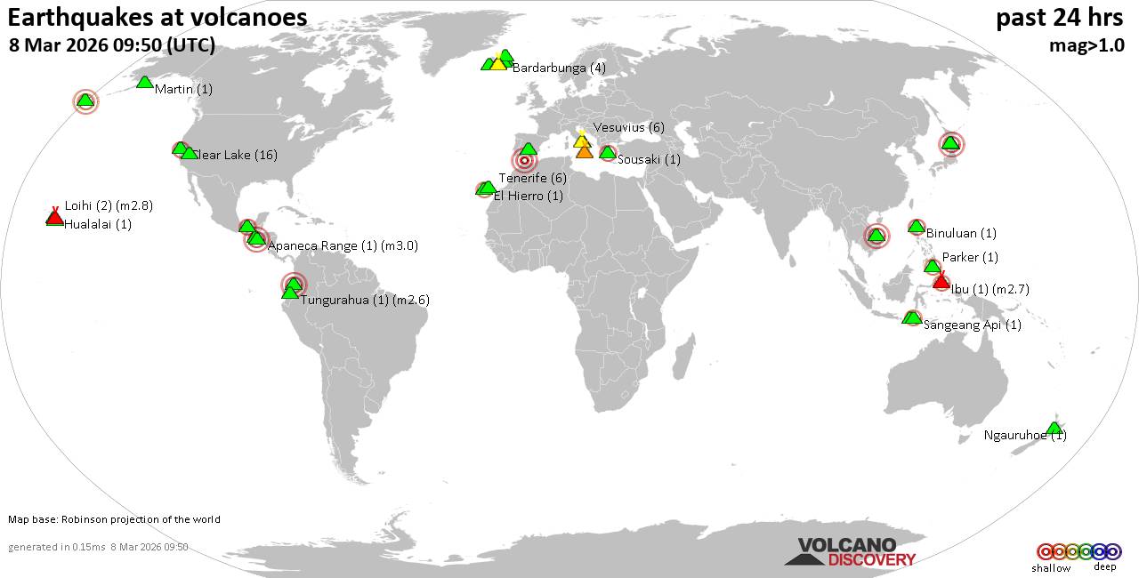 World map showing volcanoes with shallow (less than 50 km) earthquakes within 20 km radius during the past 24 hours on 8 Mar 2026 Number in brackets indicate nr of quakes. Quakes detected near: Askja (4 quakes between mag 0.0-1.2), Bratan (1 quake mag 2.1), Brennisteinsfjöll (3 quakes between mag 0.1-1.1), Calatrava (1 quake mag 3.0), Campi Flegrei (Phlegrean Fields) (11 quakes between mag 0.1-1.1), Clear Lake (40 quakes between mag 0.4-2.1)
Colima (1 quake mag 2.1), El Chichón (7 quakes between mag 1.7-2.6), Etna (1 quake mag 1.1), Galeras (2 quakes between mag 0.9-3.0), Grímsvötn (3 quakes between mag 0.0-1.3), Hengill (2 quakes between mag 0.4-1.2), Hofsjökull (1 quake mag 1.5), Hulubelu (1 quake mag 2.2), Katla (8 quakes between mag 0.3-2.2), Kilauea (3 quakes between mag 1.7-2.0), Krísuvík (2 quakes between mag 0.2-1.2), La Palma (1 quake mag 3.0), Langjökull (1 quake mag 1.1), Ljósufjöll (2 quakes between mag 0.5-1.1), Loihi (1 quake mag 1.8), Los Atlixcos (1 quake mag 4.0), Ngauruhoe (1 quake mag 1.2), Paluweh (1 quake mag 2.1), Platanar (1 quake mag 1.7), Sousaki (1 quake mag 2.0), Tambora (3 quakes between mag 2.1-2.6), Tenerife (3 quakes between mag 1.1-1.5), Tjörnes Fracture Zone (7 quakes between mag 0.5-1.2), Torfajökull (4 quakes between mag 0.1-1.4), Towada (1 quake mag 3.0), Tungurahua (1 quake mag 2.6), Vesuvius (7 quakes between mag 0.1-1.0) (updated 21h50)
Note: Earthquakes within 20 km from and at depths less than 50 km under active volcanoes are reported. The list is not complete because many volcanoes are not monitored and/or seismic data in high resolution is not available publicly.
Volcanoes with recent earthquakes above magnitude 2 or more than 10 quakes are listed below:
Bratan volcano (Bali): magnitude 2.1 earthquakeA magnitude 2.1 earthquake occurred at the volcano 2 hours ago. The quake, which might be volcanic in origin, was located at a depth of 32.00 km depth at 3 km distance NW from the volcano. Earthquake details: 2.1 quake 17 km south of Singaraja, Kabupaten Buleleng, Provinsi Bali, Indonesia, Mar 9, 2026 03:23 am (GMT +8) (3 km NW) All earthquakes at BratanCalatrava volcano (Spain): magnitude 3.0 earthquakeA magnitude 3.0 earthquake occurred at the volcano 22 hours ago. The quake, which might be volcanic in origin, was located at a depth of 10.00 km depth at 0 km distance SSW from the volcano. Earthquake details: Reported seismic-like event (likely no quake): 30 km southeast of Algeciras, Cadiz, Andalusia, Spain, Mar 8, 2026 12:33 am (GMT +1) (0 km SSW) All earthquakes at CalatravaCampi Flegrei (Phlegrean Fields) volcano (Italy): 11 earthquakes up to magnitude 1.1Possible earthquake swarm: 11 earthquakes occurred near (under) the volcano during 22 hours, the last being recorded quake 1 hour 31 minutes ago. Hypocenter depths ranged between 3.73 and 0.99 km. Earthquake details: (only 5 largest) 1.1 quake Tyrrhenian Sea, 19 km northeast of Isola d'Ischia Island, Italy, Mar 8, 2026 02:33 pm (GMT +1) (4 km SW) 0.5 quake Tyrrhenian Sea, 19 km northeast of Isola d'Ischia Island, Italy, Mar 8, 2026 03:10 pm (GMT +1) (4 km SW) 0.1 quake 1.5 km southwest of Soccavo, Napoli, Campania, Italy, Mar 8, 2026 09:18 pm (GMT +1) (3 km ENE) 0.1 quake 2 km east of Pozzuoli, Napoli, Campania, Italy, Mar 8, 2026 04:02 pm (GMT +1) (2 km NW) 0.1 quake Tyrrhenian Sea, 20 km northeast of Isola d'Ischia Island, Italy, Mar 8, 2026 02:32 pm (GMT +1) (3 km SW) All earthquakes at Campi Flegrei (Phlegrean Fields)Clear Lake volcano (California): 40 earthquakes up to magnitude 2.1Possible earthquake swarm: 40 earthquakes occurred near (under) the volcano during 24 hours, the last being recorded quake 14 minutes ago. Hypocenter depths ranged between 5.03 and 0.49 km. Earthquake details: (only 5 largest) 2.1 quake Sonoma County, 14 mi southwest of Clearlake, Lake County, California, United States, Mar 7, 2026 09:44 pm (GMT -7) (17 km SSW) 1.6 quake 26 mi north of Santa Rosa, Sonoma County, California, United States, Mar 8, 2026 06:33 am (GMT -7) (19 km S) 1.6 quake Sonoma County, 14 mi southwest of Clearlake, Lake County, California, United States, Mar 7, 2026 07:21 pm (GMT -8) (17 km SSW) 1.5 quake 12 mi southwest of Clearlake, Lake County, California, United States, Mar 7, 2026 06:05 pm (GMT -7) (17 km S) 1.3 quake 25 mi north of Santa Rosa, Sonoma County, California, United States, Mar 8, 2026 03:34 am (GMT -7) (19 km S) All earthquakes at Clear LakeColima volcano (Western & Central Mexico): magnitude 2.1 earthquakeA magnitude 2.1 earthquake occurred at the volcano 13 hours ago. The quake, which might be volcanic in origin, was located at a depth of 39.80 km depth at 19 km distance SSW from the volcano. Earthquake details: 2.1 quake 13 km north of Colima, Estado de Colima, Mexico, Mar 8, 2026 02:22 am (GMT -6) (19 km SSW) All earthquakes at ColimaEl Chichón volcano (Southern Mexico): 7 earthquakes up to magnitude 2.67 earthquakes occurred near (under) the volcano during 11 hours, the last being recorded quake 11 hours ago. Hypocenter depths ranged between 3.00 and 3.00 km. Earthquake details: (only 5 largest) 2.6 quake Estado de Chiapas, 36 km southwest of Teapa, Estado de Tabasco, Mexico, Mar 8, 2026 04:18 am (GMT -6) (1 km N) 2.5 quake Estado de Chiapas, 37 km southwest of Teapa, Estado de Tabasco, Mexico, Mar 7, 2026 05:36 pm (GMT -6) (1 km NW) 2.0 quake Estado de Chiapas, 36 km southwest of Teapa, Estado de Tabasco, Mexico, Mar 7, 2026 10:59 pm (GMT -6) (1 km N) 2.0 quake Estado de Chiapas, 37 km southwest of Teapa, Estado de Tabasco, Mexico, Mar 8, 2026 04:54 am (GMT -6) (1 km NW) 1.9 quake Estado de Chiapas, 36 km southwest of Teapa, Estado de Tabasco, Mexico, Mar 8, 2026 03:44 am (GMT -6) (1 km N) All earthquakes at El ChichónGaleras volcano (Colombia): 2 earthquakes up to magnitude 3.02 earthquakes occurred near (under) the volcano during 1 hour 34 minutes, the last being recorded quake 16 hours ago. Hypocenter depths ranged between 10.00 and 2.00 km. Earthquake details: Reported seismic-like event (likely no quake): 3.6 km west of Pasto, Departamento de Narino, Colombia, Mar 7, 2026 11:23 pm (GMT -5) (7 km ESE) 0.9 quake 7.2 km south of Pasto, Departamento de Narino, Colombia, Mar 8, 2026 12:58 am (GMT -5) (11 km SE) All earthquakes at GalerasHulubelu volcano (Sumatra): magnitude 2.2 earthquakeA magnitude 2.2 earthquake occurred at the volcano 5 hours ago. The quake, which might be volcanic in origin, was located at a depth of 4.00 km depth at 19 km distance SSW from the volcano. Earthquake details: 2.2 quake Kabupaten Tanggamus, 84 km west of Bandar Lampung, Indonesia, Mar 8, 2026 11:40 pm (GMT +7) (19 km SSW) All earthquakes at HulubeluKatla volcano (Iceland): 8 earthquakes up to magnitude 2.28 earthquakes occurred near (under) the volcano during 8 hours, the last being recorded quake 34 minutes ago. Hypocenter depths ranged between 5.20 and 0.00 km. Earthquake details: (only 5 largest) 2.2 quake 3.6 km SE of Goðabunga Mar 8, 2026 03:57 pm (Universal Time) (8 km WSW) 1.2 quake Iceland: 2.3 km SE of Goðabunga Mar 8, 2026 04:00 pm (Reykjavik time) (8 km W) 0.7 quake Iceland: 2.6 km ESE of Goðabunga Mar 8, 2026 08:36 pm (Reykjavik time) (7 km W) 0.7 quake Iceland: 2.3 km SE of Goðabunga Mar 8, 2026 04:21 pm (Reykjavik time) (8 km W) 0.5 quake Iceland: 2.5 km ESE of Goðabunga Mar 8, 2026 09:15 pm (Reykjavik time) (7 km W) All earthquakes at KatlaLa Palma volcano (Canary Islands): magnitude 3.0 earthquakeA magnitude 3.0 earthquake occurred at the volcano 4 hours ago. The quake, which might be volcanic in origin, was located at a depth of 10.00 km depth at 10 km distance NW from the volcano. Earthquake details: Reported seismic-like event (likely no quake): 2.7 km south of Los Llanos de Aridane, Spain, Mar 8, 2026 06:00 pm (GMT +0) (10 km NW) All earthquakes at La PalmaLos Atlixcos volcano (Western & Central Mexico): magnitude 4.0 earthquakeA magnitude 4.0 earthquake occurred at the volcano 11 hours ago. The quake, which might be volcanic in origin, was located at a depth of 12.20 km depth at 19 km distance N from the volcano. Earthquake details: 4.0 quake 63 km northeast of Xalapa, Estado de Veracruz-Llave, Mexico, Mar 8, 2026 04:26 am (GMT -6) (19 km N) All earthquakes at Los AtlixcosPaluweh volcano (Lesser Sunda Islands): magnitude 2.1 earthquakeA magnitude 2.1 earthquake occurred at the volcano 11 hours ago. The quake, which might be volcanic in origin, was located at a depth of 20.00 km depth at 10 km distance ENE from the volcano. Earthquake details: 2.1 quake Flores Sea, 59 km northwest of Maumere, Indonesia, Mar 8, 2026 07:11 pm (GMT +8) (10 km ENE) All earthquakes at PaluwehTambora volcano (Sumbawa): 3 earthquakes up to magnitude 2.63 earthquakes occurred near (under) the volcano during 23 hours, the last being recorded quake 26 minutes ago. Hypocenter depths ranged between 38.00 and 23.00 km. Earthquake details: 2.6 quake Kabupaten Bima, 58 km northeast of Sumbawa Besar, Indonesia, Mar 8, 2026 06:52 pm (GMT +8) (16 km WNW) 2.2 quake Kabupaten Bima, 57 km northeast of Sumbawa Besar, Indonesia, Mar 9, 2026 05:23 am (GMT +8) (19 km WNW) 2.1 quake Kabupaten Dompu, 60 km northeast of Sumbawa Besar, Indonesia, Mar 8, 2026 06:01 am (GMT +8) (11 km W) All earthquakes at TamboraTowada volcano (Honshu): magnitude 3.0 earthquakeA magnitude 3.0 earthquake occurred at the volcano 18 hours ago. The quake, which might be volcanic in origin, was located at a depth of 10.00 km depth at 15 km distance SSE from the volcano. Earthquake details: Reported seismic-like event (likely no quake): 24 km northeast of Hanawa, Akita, Japan, Mar 8, 2026 12:20 pm (GMT +9) (15 km SSE) All earthquakes at TowadaTungurahua volcano (Ecuador): magnitude 2.6 earthquakeA magnitude 2.6 earthquake occurred at the volcano 18 hours ago. The quake, which might be volcanic in origin, was located at a depth of 11.00 km depth at 18 km distance W from the volcano. Earthquake details: 2.6 quake 26 km south of Ambato, Tungurahua, Ecuador, Mar 7, 2026 10:22 pm (GMT -5) (18 km W) All earthquakes at Tungurahuahttps://www.volcanodiscovery.com/earthquakes-volcanoes/news/297009/Volcano-earthquake-report-for-Sunday-8-Mar-2026.html
|
|


CMS The Best Conveyancing solicitors conveyancing quotes throughout the UK
For any webhosting enquiries please email webmaster@aus-city.com
|
|
Entire Thread
|
 Volcano earthquake report for Sunday, 8 Mar 2026
|
Webmaster
|
Sun 08 Mar 2026 09:50:PM
|
|
Forums60
Topics793,510
Posts828,294
Members2,960
| |
Most Online102,106
Jul 10th, 2026
|
|
|
|
|
Copyright 1996 - 2026 by David Cottle. Designed by David Bate Jr. All Rights Reserved.
By using this forum, the user agrees not to transfer any data or technical information received under this agreement to any other entity without the express approval of the AUS-CITY Forum Admins and/or authors of individual posts (Forum Admins and DoD/USSPACECOM for the analysis of satellite tracking data).
Two-line elements (TLE) and all other satellite data presented and distributed via this forum and AUS-CITY mailing lists are distributed with permission from DoD/USSTRATCOM.

|

|


 - Click image for larger picture.")


