|
|
|
0 members (),
1,709
guests, and
63
robots. |
|
Key:
Admin,
Global Mod,
Mod
|
|
S |
M |
T |
W |
T |
F |
S |
|
|
|
|
1
|
2
|
3
|
4
|
|
5
|
6
|
7
|
8
|
9
|
10
|
11
|
|
12
|
13
|
14
|
15
|
16
|
17
|
18
|
|
19
|
20
|
21
|
22
|
23
|
24
|
25
|
|
26
|
27
|
28
|
29
|
30
|
31
|
|
|
There are no members with birthdays on this day. |

Volcano earthquake report for Saturday, 25 Jul 2026
• Moderate mag. 4.1 earthquake - North Pacific Ocean, 167 km southwest of Ret...
• Moderate mag. 4.1 earthquake - North Pacific Ocean, 167 km southwest of Ret...
• Moderate mag. 4.0 earthquake - South Pacific Ocean, 58 km west of Vallenar,...
• Moderate mag. 4.0 earthquake - South Pacific Ocean, 58 km west of Vallenar,...
|

#804258
Thu 02 Apr 2026 03:50:AM
|
Joined: Feb 2001
Posts: 678,976
Launch Director
|
OP

Launch Director
Joined: Feb 2001
Posts: 678,976 |
Volcano earthquake report for Thursday, 2 Apr 2026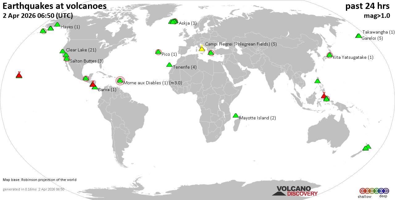 World map showing volcanoes with shallow (less than 50 km) earthquakes within 20 km radius during the past 24 hours on 2 Apr 2026 Number in brackets indicate nr of quakes. Quakes detected near: Apoyeque (1 quake mag 1.7), Askja (3 quakes between mag 0.0-1.2), Barva (1 quake mag 2.1), Campi Flegrei (Phlegrean Fields) (3 quakes between mag 0.1-1.2), Clear Lake (27 quakes between mag 0.2-2.1), Coso (2 quakes between mag 0.9-1.0)
El Chichón (3 quakes between mag 1.9-3.0), Gareloi (5 quakes between mag 0.4-1.3), Griggs (1 quake mag 1.0), Grímsvötn (3 quakes between mag 0.7-1.2), Hayes (1 quake mag 1.0), Hrómundartindur (15 quakes between mag 0.0-3.0), Hulubelu (3 quakes between mag 2.5-2.5), Kerlingarfjöll (1 quake mag 1.1), Kilauea (1 quake mag 1.9), Kita Yatsugatake (1 quake mag 2.5), Kupreanof (4 quakes between mag 1.3-2.6), Loihi (1 quake mag 2.1), Loki-Fögrufjöll volcano (2 quakes between mag 0.1-1.2), Masaya (1 quake mag 1.3), Maunaloa (1 quake mag 2.2), Mayotte Island (2 quakes between mag 1.2-1.5), Morne aux Diables (1 quake mag 3.0), Moti (1 quake mag 2.9), Pico (1 quake mag 2.1), Pinatubo (1 quake mag 1.7), Ruapehu (2 quakes between mag 0.7-1.2), Salton Buttes (3 quakes between mag 1.1-2.1), Sousaki (1 quake mag 2.1), Stepovak Bay 4 (1 quake mag 1.4), Tenerife (5 quakes between mag 1.0-1.7), Tongariro (12 quakes between mag 0.7-2.0), Torfajökull (9 quakes between mag 0.1-1.7), Trident (1 quake mag 1.0), Whale Island (1 quake mag 1.8) (updated 03h50)
Note: Earthquakes within 20 km from and at depths less than 50 km under active volcanoes are reported. The list is not complete because many volcanoes are not monitored and/or seismic data in high resolution is not available publicly.
Volcanoes with recent earthquakes above magnitude 2 or more than 10 quakes are listed below:
Barva volcano (Costa Rica): magnitude 2.1 earthquakeA magnitude 2.1 earthquake occurred at the volcano 21 hours ago. The quake, which might be volcanic in origin, was located at a depth of 16.00 km depth at 15 km distance ENE from the volcano. Earthquake details: 2.1 quake Provincia de Heredia, 31 km northeast of San Jose, Costa Rica, Apr 1, 2026 01:14 am (Costa_Rica time) (15 km ENE) All earthquakes at BarvaClear Lake volcano (California): 27 earthquakes up to magnitude 2.1Possible earthquake swarm: 27 earthquakes occurred near (under) the volcano during 22 hours, the last being recorded quake 1 hour 46 minutes ago. Hypocenter depths ranged between 8.43 and 0.65 km. Earthquake details: (only 5 largest) 2.1 quake Sonoma County, 14 mi southwest of Clearlake, Lake County, California, United States, Apr 1, 2026 03:34 am (GMT -7) (16 km SSW) 1.5 quake Sonoma County, 14 mi southwest of Clearlake, Lake County, California, United States, Apr 1, 2026 04:46 am (GMT -7) (18 km S) 1.3 quake Lake County, 26 mi north of Santa Rosa, Sonoma County, California, United States, Mar 31, 2026 11:17 pm (GMT -7) (17 km S) 1.2 quake 25 mi north of Santa Rosa, Sonoma County, California, United States, Apr 1, 2026 03:15 pm (GMT -7) (19 km S) 1.2 quake Lake County, 26 mi north of Santa Rosa, Sonoma County, California, United States, Apr 1, 2026 12:16 am (GMT -7) (17 km S) All earthquakes at Clear LakeEl Chichón volcano (Southern Mexico): 3 earthquakes up to magnitude 3.03 earthquakes occurred near (under) the volcano during 3 hours, the last being recorded quake 18 hours ago. Hypocenter depths ranged between 3.20 and 2.90 km. Earthquake details: 3.0 quake Estado de Chiapas, 37 km southwest of Teapa, Estado de Tabasco, Mexico, Apr 1, 2026 04:18 am (GMT -6) (1 km WSW) 2.5 quake Estado de Chiapas, 37 km southwest of Teapa, Estado de Tabasco, Mexico, Apr 1, 2026 01:12 am (GMT -6) (1 km SW) 1.9 quake Estado de Chiapas, 36 km southwest of Teapa, Estado de Tabasco, Mexico, Apr 1, 2026 01:09 am (GMT -6) (1 km ESE) All earthquakes at El ChichónHrómundartindur volcano (Iceland): 15 earthquakes up to magnitude 3.0Possible earthquake swarm: 15 earthquakes occurred near (under) the volcano during 5 hours, the last being recorded quake 8 hours ago. Hypocenter depths ranged between 8.50 and 2.40 km. Earthquake details: (only 5 largest) 3.0 quake 37 km southeast of Reykjavik, Capital Region, Iceland, Apr 1, 2026 06:49 pm (Reykjavik time) (13 km SSW) 2.3 quake 4.2 km NE of Skeggi_á_Hengli Apr 1, 2026 07:11 pm (Universal Time) (5 km NNW) 1.6 quake Iceland: 3.5 km NW of Hrómundartindi Apr 1, 2026 07:12 pm (Reykjavik time) (4 km NW) 1.4 quake 1.7 km E of Skeggi_á_Hengli Apr 1, 2026 06:52 pm (Universal Time) (5 km WNW) 1.3 quake 4.1 km NNW of Hrómundartindi Apr 1, 2026 07:24 pm (Universal Time) (5 km NNW) All earthquakes at HrómundartindurHulubelu volcano (Sumatra): 3 earthquakes up to magnitude 2.53 earthquakes occurred near (under) the volcano during 8 minutes, the last being recorded quake 22 hours ago. Hypocenter depths ranged between 4.00 and 3.00 km. Earthquake details: 2.5 quake Kabupaten Tanggamus, 74 km west of Bandar Lampung, Indonesia, Apr 1, 2026 01:01 pm (GMT +7) (9 km S) 2.5 quake Kabupaten Tanggamus, 78 km west of Bandar Lampung, Indonesia, Apr 1, 2026 12:59 pm (GMT +7) (13 km S) 2.5 quake Kabupaten Tanggamus, 75 km west of Bandar Lampung, Indonesia, Apr 1, 2026 12:53 pm (GMT +7) (2 km SSE) All earthquakes at HulubeluKita Yatsugatake volcano (Honshu): magnitude 2.5 earthquakeA magnitude 2.5 earthquake occurred at the volcano 1 hour 19 minutes ago. The quake, which might be volcanic in origin, was located at a depth of 9.20 km depth at 18 km distance WSW from the volcano. Earthquake details: 2.5 quake 3 km northwest of Chino, Nagano, Japan, Apr 2, 2026 11:30 am (GMT +9) (18 km WSW) All earthquakes at Kita YatsugatakeKupreanof volcano (Alaska Peninsula): 4 earthquakes up to magnitude 2.64 earthquakes occurred near (under) the volcano during 17 hours, the last being recorded quake 3 hours ago. Hypocenter depths ranged between 48.10 and 12.00 km. Earthquake details: 2.6 quake Lake and Peninsula Borough, 61 mi northeast of Sand Point, Aleutians East Borough, Alaska, United States, Apr 1, 2026 03:00 pm (GMT -8) (13 km ENE) 1.5 quake Lake and Peninsula Borough, 53 mi northeast of Sand Point, Aleutians East Borough, Alaska, United States, Apr 1, 2026 03:18 pm (GMT -8) (8 km SE) 1.4 quake Lake and Peninsula Borough, 51 mi northeast of Sand Point, Aleutians East Borough, Alaska, United States, Apr 1, 2026 04:37 pm (GMT -8) (9 km SSE) 1.3 quake Lake and Peninsula Borough, 54 mi northeast of Sand Point, Aleutians East Borough, Alaska, United States, Mar 31, 2026 11:54 pm (GMT -8) (9 km ESE) All earthquakes at KupreanofLoihi volcano (Hawai'i (Big Island)): magnitude 2.1 earthquakeA magnitude 2.1 earthquake occurred at the volcano 13 hours ago. The quake, which might be volcanic in origin, was located at a depth of 31.66 km depth at 18 km distance NW from the volcano. Earthquake details: 2.1 quake North Pacific Ocean, 40 mi southeast of of Hawai‘i Island, Hawaii County, Hawaii, United States, Apr 1, 2026 04:35 am (GMT -10) (18 km NW) All earthquakes at LoihiMaunaloa volcano (Hawai'i (Big Island)): magnitude 2.2 earthquakeA magnitude 2.2 earthquake occurred at the volcano 15 hours ago. The quake, which might be volcanic in origin, was located at a depth of 3.65 km depth at 11 km distance E from the volcano. Earthquake details: 2.2 quake 32 mi southwest of Hilo, Hawaii County, Hawaii, United States, Apr 1, 2026 02:30 am (GMT -10) (11 km E) All earthquakes at MaunaloaMorne aux Diables volcano (Caribbean): magnitude 3.0 earthquakeA magnitude 3.0 earthquake occurred at the volcano 1 hour 16 minutes ago. The quake, which might be volcanic in origin, was located at a depth of 10.00 km depth at 5 km distance SSW from the volcano. Earthquake details: Reported seismic-like event (likely no quake): 30 km north of Roseau, Saint George, Dominica, Apr 1, 2026 10:33 pm (GMT -4) (5 km SSW) All earthquakes at Morne aux DiablesMoti volcano (Halmahera): magnitude 2.9 earthquakeA magnitude 2.9 earthquake occurred at the volcano 4 hours ago. The quake, which might be volcanic in origin, was located at a depth of 21.00 km depth at 5 km distance WSW from the volcano. Earthquake details: 2.9 quake Maluku Sea, 5.7 km west of Pulau Moty Island, North Maluku, Indonesia, Apr 2, 2026 08:26 am (GMT +9) (5 km WSW) All earthquakes at MotiPico volcano (Azores): magnitude 2.1 earthquakeA magnitude 2.1 earthquake occurred at the volcano 7 hours ago. The quake, which might be volcanic in origin, was located at a depth of 7.00 km depth at 16 km distance NW from the volcano. Earthquake details: 2.1 quake North Atlantic Ocean, 19 km northwest of Pico Island, Azores, Portugal, Apr 1, 2026 08:50 pm (Universal Time) (16 km NW) All earthquakes at PicoSalton Buttes volcano (California): 3 earthquakes up to magnitude 2.13 earthquakes occurred near (under) the volcano during 18 hours, the last being recorded quake 1 hour 22 minutes ago. Hypocenter depths ranged between 10.29 and 3.31 km. Earthquake details: 2.1 quake 14 mi northwest of Brawley, Imperial County, California, United States, Apr 1, 2026 01:04 am (GMT -7) (5 km SSW) 1.6 quake 14 mi northwest of Brawley, Imperial County, California, United States, Apr 1, 2026 01:04 am (GMT -7) (4 km SSW) 1.1 quake 13 mi north of Brawley, Imperial County, California, United States, Apr 1, 2026 07:28 pm (GMT -7) (5 km SE) All earthquakes at Salton ButtesSousaki volcano (Greece): magnitude 2.1 earthquakeA magnitude 2.1 earthquake occurred at the volcano 7 hours ago. The quake, which might be volcanic in origin, was located at a depth of 7.69 km depth at 12 km distance SSE from the volcano. Earthquake details: 2.1 quake Aegean Sea, 54 km west of Athens, Nomarchia Athinas, Attica, Greece, Apr 1, 2026 11:21 pm (GMT +3) (12 km SSE) All earthquakes at SousakiTongariro volcano (North Island): 12 earthquakes up to magnitude 2.0Possible earthquake swarm: 12 earthquakes occurred near (under) the volcano during 1 hour 14 minutes, the last being recorded quake 2 hours ago. Hypocenter depths ranged between 7.40 and 3.50 km. Earthquake details: (only 5 largest) 2.0 quake 9.5 km west of Turangi, Waikato, New Zealand, Apr 2, 2026 01:40 pm (GMT +13) (13 km NNE) 1.6 quake 8.3 km west of Turangi, Waikato, New Zealand, Apr 2, 2026 02:08 pm (GMT +13) (14 km NNE) 1.3 quake 49 km southwest of Taupo, Waikato, New Zealand, Apr 2, 2026 02:37 pm (GMT +13) (13 km NNE) 1.2 quake 48 km southwest of Taupo, Waikato, New Zealand, Apr 2, 2026 01:24 pm (GMT +13) (14 km NNE) 1.2 quake 49 km southwest of Taupo, Waikato, New Zealand, Apr 2, 2026 01:23 pm (GMT +13) (14 km NNE) All earthquakes at Tongarirohttps://www.volcanodiscovery.com/earthquakes-volcanoes/news/299066/Volcano-earthquake-report-for-Thursday-2-Apr-2026.html
|
|


CMS The Best Conveyancing solicitors conveyancing quotes throughout the UK
For any webhosting enquiries please email webmaster@aus-city.com
|
|
Entire Thread
|
 Volcano earthquake report for Thursday, 2 Apr 2026
|
Webmaster
|
Thu 02 Apr 2026 03:50:AM
|
|
Forums60
Topics792,785
Posts827,567
Members2,960
| |
Most Online102,106
Jul 10th, 2026
|
|
|
|
|
Copyright 1996 - 2026 by David Cottle. Designed by David Bate Jr. All Rights Reserved.
By using this forum, the user agrees not to transfer any data or technical information received under this agreement to any other entity without the express approval of the AUS-CITY Forum Admins and/or authors of individual posts (Forum Admins and DoD/USSPACECOM for the analysis of satellite tracking data).
Two-line elements (TLE) and all other satellite data presented and distributed via this forum and AUS-CITY mailing lists are distributed with permission from DoD/USSTRATCOM.

|

|


 - Click image for larger picture.")


