|
|
|
0 members (),
887
guests, and
33
robots. |
|
Key:
Admin,
Global Mod,
Mod
|
|
S |
M |
T |
W |
T |
F |
S |
|
|
|
|
|
|
1
|
2
|
|
3
|
4
|
5
|
6
|
7
|
8
|
9
|
|
10
|
11
|
12
|
13
|
14
|
15
|
16
|
|
17
|
18
|
19
|
20
|
21
|
22
|
23
|
|
24
|
25
|
26
|
27
|
28
|
29
|
30
|
|
31
|
|
|
|
|
|
|
|
There are no members with birthdays on this day. |

Volcano earthquake report for Thursday, 28 May 2026
• World Earthquake Report for Thursday, 28 May 2026
• Small magnitude 3.7 quake hits 7 km northwest of Mataram, Indonesia early m...
• Moderate mag. 4.0 earthquake - Offshore Chiapas, Mexico, on Thursday, May 2...
• Moderate mag. 4.2 earthquake - North Pacific Ocean, 159 km south of David, ...
• World Earthquake Report for May 2026
|

#805456
Sun 12 Apr 2026 11:50:AM
|
Joined: Feb 2001
Posts: 381,904
Launch Director
|
OP

Launch Director
Joined: Feb 2001
Posts: 381,904 |
Volcano earthquake report for Sunday, 12 Apr 2026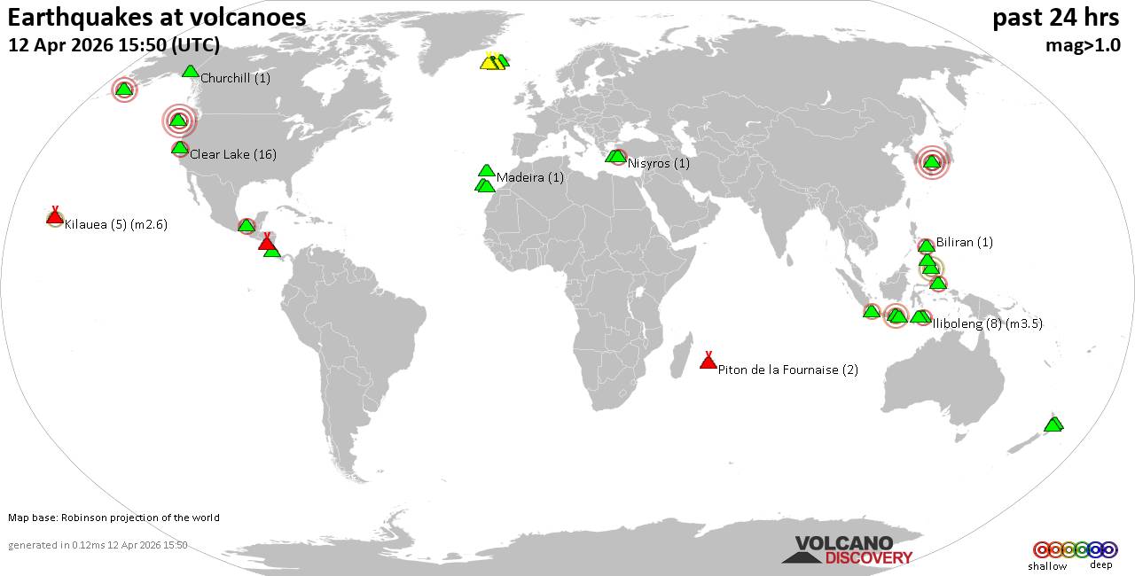 World map showing volcanoes with shallow (less than 50 km) earthquakes within 20 km radius during the past 24 hours on 12 Apr 2026 Number in brackets indicate nr of quakes. Quakes detected near: Baluran (2 quakes between mag 2.8-3.2), Bardarbunga (4 quakes between mag 1.1-1.6), Barva (4 quakes between mag 1.8-2.7), Biliran (1 quake mag 2.5), Brennisteinsfjöll (3 quakes between mag 0.2-1.1), Churchill (1 quake mag 1.0)
Clear Lake (17 quakes between mag 0.4-2.3), Cobb Segment (5 quakes between mag 2.9-3.7), El Chichón (2 quakes between mag 2.3-2.4), Etna (1 quake mag 1.1), Eyafjallajökull (1 quake mag 1.5), Gagak (1 quake mag 2.1), Grímsnes (14 quakes between mag 0.0-1.6), Hekla (1 quake mag 1.0), Iliboleng (8 quakes between mag 2.1-3.5), Jailolo (2 quakes between mag 2.1-2.2), Katla (10 quakes between mag 0.0-1.4), Kilauea (5 quakes between mag 1.7-2.6), Kolumbo (1 quake mag 1.2), La Palma (1 quake mag 1.8), Latukan (2 quakes between mag 1.6-2.2), Madeira (1 quake mag 1.4), Mammoth Mountain (1 quake mag 1.3), Maroa (5 quakes between mag 1.6-2.4), Masaya (6 quakes between mag 1.1-3.1), Nisyros (1 quake mag 2.0), Okataina (Tarawera) (1 quake mag 2.5), Piton de la Fournaise (3 quakes between mag 0.3-1.5), Sanbe (1 quake mag 4.0), Svartsengi (1 quake mag 1.0), Tenerife (11 quakes between mag 1.0-2.0), Tjörnes Fracture Zone (3 quakes between mag 0.6-1.4), Torfajökull (3 quakes between mag 0.9-1.0) (updated 11h50)
Note: Earthquakes within 20 km from and at depths less than 50 km under active volcanoes are reported. The list is not complete because many volcanoes are not monitored and/or seismic data in high resolution is not available publicly.
Volcanoes with recent earthquakes above magnitude 2 or more than 10 quakes are listed below:
Baluran volcano (East Java): 2 earthquakes up to magnitude 3.22 earthquakes occurred near (under) the volcano during 1 hour 22 minutes, the last being recorded quake 10 hours ago. Hypocenter depths ranged between 25.00 and 17.00 km. Earthquake details: 3.2 quake Kabupaten Situbondo, 19 km north of Wongsorejo, Indonesia, Apr 12, 2026 09:04 am (GMT +7) (6 km NE) 2.8 quake Kabupaten Situbondo, 17 km north of Wongsorejo, Indonesia, Apr 12, 2026 07:43 am (GMT +7) (1 km N) All earthquakes at BaluranBarva volcano (Costa Rica): 4 earthquakes up to magnitude 2.74 earthquakes occurred near (under) the volcano during 14 hours, the last being recorded quake 4 hours ago. Hypocenter depths ranged between 13.00 and 0.00 km. Earthquake details: 2.7 quake Provincia de Heredia, 27 km northeast of San Jose, Costa Rica, Apr 12, 2026 01:42 am (GMT -6) (14 km ENE) 2.4 quake Provincia de Heredia, 27 km northeast of San Jose, Costa Rica, Apr 11, 2026 11:42 am (Costa_Rica time) (13 km E) 1.8 quake Provincia de Heredia, 27 km north of San Jose, Provincia de San Jose, Costa Rica, Apr 12, 2026 01:43 am (Costa_Rica time) (12 km E) 1.8 quake 28 km northeast of San Jose, Provincia de San Jose, Costa Rica, Apr 11, 2026 12:18 pm (Costa_Rica time) (14 km E) All earthquakes at BarvaBiliran volcano (Central Philippines): magnitude 2.5 earthquakeA magnitude 2.5 earthquake occurred at the volcano 9 hours ago. The quake, which might be volcanic in origin, was located at a depth of 26.00 km depth at 8 km distance W from the volcano. Earthquake details: 2.5 quake 8.2 km southeast of Naval, Biliran, Eastern Visayas, Philippines, Apr 12, 2026 11:12 am (GMT +8) (8 km W) All earthquakes at BiliranClear Lake volcano (California): 17 earthquakes up to magnitude 2.3Possible earthquake swarm: 17 earthquakes occurred near (under) the volcano during 21 hours, the last being recorded quake 1 hour 12 minutes ago. Hypocenter depths ranged between 3.82 and 0.33 km. Earthquake details: (only 5 largest) 2.3 quake 12 mi southwest of Clearlake, Lake County, California, United States, Apr 12, 2026 02:25 am (GMT -7) (15 km S) 1.6 quake Sonoma County, 13 mi southwest of Clearlake, Lake County, California, United States, Apr 11, 2026 11:53 am (GMT -7) (19 km S) 1.3 quake 25 mi north of Santa Rosa, Sonoma County, California, United States, Apr 11, 2026 04:10 pm (GMT -7) (19 km S) 1.2 quake 27 mi north of Santa Rosa, Sonoma County, California, United States, Apr 11, 2026 07:01 am (GMT -7) (18 km SSW) 1.2 quake 27 mi north of Santa Rosa, Sonoma County, California, United States, Apr 11, 2026 11:28 pm (GMT -7) (17 km SSW) All earthquakes at Clear LakeCobb Segment volcano (Northern Pacific Ocean): 5 earthquakes up to magnitude 3.75 earthquakes occurred near (under) the volcano during 1 hour 17 minutes, the last being recorded quake 2 hours ago. Hypocenter depths ranged between 10.00 and 10.00 km. Earthquake details: 3.7 quake North Pacific Ocean, 364 km southwest of Tofino, Regional District of Alberni-Clayoquot, British Columbia, Canada, Apr 12, 2026 12:47 am (GMT -9) (6 km SSW) 3.0 quake Off the Coast of Washington Apr 11, 2026 11:59 pm (GMT -9) (19 km WSW) 3.0 quake Off the Coast of Washington Apr 11, 2026 11:30 pm (GMT -9) (4 km NE) 2.9 quake Off the Coast of Washington Apr 12, 2026 12:07 am (GMT -9) (16 km E) 2.9 quake Off the Coast of Washington Apr 11, 2026 11:49 pm (GMT -9) (11 km E) All earthquakes at Cobb SegmentEl Chichón volcano (Southern Mexico): 2 earthquakes up to magnitude 2.42 earthquakes occurred near (under) the volcano during 6 hours, the last being recorded quake 15 hours ago. Hypocenter depths ranged between 9.00 and 2.80 km. Earthquake details: 2.4 quake Estado de Chiapas, 37 km southwest of Teapa, Estado de Tabasco, Mexico, Apr 11, 2026 02:37 pm (GMT -6) (1 km NW) 2.3 quake Estado de Chiapas, 33 km southwest of Teapa, Estado de Tabasco, Mexico, Apr 11, 2026 08:17 am (GMT -6) (4 km NNE) All earthquakes at El ChichónGagak volcano (West Java): magnitude 2.1 earthquakeA magnitude 2.1 earthquake occurred at the volcano 8 hours ago. The quake, which might be volcanic in origin, was located at a depth of 23.00 km depth at 4 km distance NE from the volcano. Earthquake details: 2.1 quake Bogor Regency, 15 km northwest of Cicurug, Indonesia, Apr 12, 2026 10:47 am (GMT +7) (4 km NE) All earthquakes at GagakGrímsnes volcano (Iceland): 14 earthquakes up to magnitude 1.6Possible earthquake swarm: 14 earthquakes occurred near (under) the volcano during 1 hour 4 minutes, the last being recorded quake 28 minutes ago. Hypocenter depths ranged between 5.10 and 0.00 km. Earthquake details: (only 5 largest) 1.6 quake 6.6 km NW of Þjórsárbrú Apr 12, 2026 10:41 am (Universal Time) (9 km SE) 1.6 quake Iceland: 6.5 km NW of Þjórsárbrú Apr 12, 2026 10:45 am (Reykjavik time) (9 km SE) 1.4 quake Iceland: 5.4 km WNW of Þjórsárbrú Apr 12, 2026 10:35 am (Reykjavik time) (10 km SE) 1.3 quake Iceland: 7.0 km WNW of Þjórsárbrú Apr 12, 2026 10:17 am (Reykjavik time) (9 km SSE) 1.2 quake 6.7 km NW of Þjórsárbrú Apr 12, 2026 10:47 am (Universal Time) (9 km SE) All earthquakes at GrímsnesIliboleng volcano (Lesser Sunda Islands): 8 earthquakes up to magnitude 3.58 earthquakes occurred near (under) the volcano during 22 hours, the last being recorded quake 45 minutes ago. Hypocenter depths ranged between 7.00 and 3.00 km. Earthquake details: (only 5 largest) 3.5 quake Kabupaten Flores Timur, 33 km west of Lewoleba, Indonesia, Apr 12, 2026 03:53 pm (GMT +8) (15 km W) 2.9 quake Kabupaten Flores Timur, 32 km west of Lewoleba, Indonesia, Apr 11, 2026 08:42 pm (GMT +8) (17 km SW) 2.8 quake Kabupaten Flores Timur, 27 km west of Lewoleba, Indonesia, Apr 12, 2026 03:10 pm (GMT +8) (11 km WSW) 2.4 quake Kabupaten Flores Timur, 32 km west of Lewoleba, Indonesia, Apr 12, 2026 11:00 am (GMT +8) (17 km SW) 2.4 quake Savu Sea, 16 km south of Pulau Adonara Island, East Nusa Tenggara, Indonesia, Apr 12, 2026 05:10 am (GMT +8) (16 km SSW) All earthquakes at IlibolengJailolo volcano (Halmahera): 2 earthquakes up to magnitude 2.22 earthquakes occurred near (under) the volcano during 4 hours, the last being recorded quake 12 hours ago. Hypocenter depths ranged between 9.00 and 6.00 km. Earthquake details: 2.2 quake Kabupaten Halmahera Barat, 34 km north of Ternate, Indonesia, Apr 12, 2026 05:22 am (GMT +9) (9 km E) 2.1 quake Kabupaten Halmahera Barat, 40 km north of Ternate, Indonesia, Apr 12, 2026 09:00 am (GMT +9) (9 km NE) All earthquakes at JailoloKilauea volcano (Hawai'i (Big Island)): 5 earthquakes up to magnitude 2.65 earthquakes occurred near (under) the volcano during 5 hours, the last being recorded quake 14 hours ago. Hypocenter depths ranged between 29.17 and 5.90 km. Earthquake details: 2.6 quake 35 mi southwest of Hilo, Hawaii County, Hawaii, United States, Apr 11, 2026 11:49 am (GMT -10) (16 km SW) 2.6 quake 36 mi southwest of Hilo, Hawaii County, Hawaii, United States, Apr 11, 2026 11:49 am (GMT -10) (18 km SW) 1.7 quake 36 mi southwest of Hilo, Hawaii County, Hawaii, United States, Apr 11, 2026 08:35 am (GMT -10) (17 km SW) 1.7 quake 36 mi southwest of Hilo, Hawaii County, Hawaii, United States, Apr 11, 2026 08:03 am (GMT -10) (17 km SW) 1.7 quake 28 mi southwest of Hilo, Hawaii County, Hawaii, United States, Apr 11, 2026 06:43 am (GMT -10) (18 km WNW) All earthquakes at KilaueaLatukan volcano (Mindanao): 2 earthquakes up to magnitude 2.22 earthquakes occurred near (under) the volcano during 7 minutes, the last being recorded quake 18 hours ago. Hypocenter depths ranged between 8.00 and 8.00 km. Earthquake details: 2.2 quake 44 km north of Midsayap, Cotabato, Soccsksargen, Philippines, Apr 12, 2026 01:44 am (GMT +8) (8 km SSE) 1.6 quake 41 km north of Midsayap, Cotabato, Soccsksargen, Philippines, Apr 12, 2026 01:51 am (GMT +8) (11 km SSE) All earthquakes at LatukanMaroa volcano (New Zealand): 5 earthquakes up to magnitude 2.45 earthquakes occurred near (under) the volcano during 3 hours, the last being recorded quake 19 hours ago. Hypocenter depths ranged between 4.70 and 3.60 km. Earthquake details: 2.4 quake 18 km northeast of Taupo, Waikato, New Zealand, Apr 12, 2026 02:17 am (GMT +12) (16 km SE) 2.0 quake 19 km northeast of Taupo, Waikato, New Zealand, Apr 12, 2026 01:24 am (GMT +12) (15 km SE) 1.7 quake 19 km northeast of Taupo, Waikato, New Zealand, Apr 12, 2026 04:25 am (GMT +12) (17 km SE) 1.6 quake 18 km northeast of Taupo, Waikato, New Zealand, Apr 12, 2026 01:42 am (GMT +12) (16 km SE) 1.6 quake 18 km northeast of Taupo, Waikato, New Zealand, Apr 12, 2026 01:23 am (GMT +12) (17 km SE) All earthquakes at MaroaMasaya volcano (Nicaragua): 6 earthquakes up to magnitude 3.16 earthquakes occurred near (under) the volcano during 1 hour 5 minutes, the last being recorded quake 7 hours ago. Hypocenter depths ranged between 16.00 and 4.00 km. Earthquake details: (only 5 largest) 3.1 quake 2.6 km west of Masaya, Departamento de Masaya, Nicaragua, Apr 11, 2026 09:53 pm (GMT -6) (5 km ESE) 2.4 quake 10.6 km south of Masaya, Departamento de Masaya, Nicaragua, Apr 11, 2026 10:01 pm (GMT -6) (12 km SSE) 1.8 quake 3 km west of Masaya, Departamento de Masaya, Nicaragua, Apr 11, 2026 10:33 pm (GMT -6) (4 km E) 1.7 quake 4.5 km west of Masaya, Departamento de Masaya, Nicaragua, Apr 11, 2026 09:55 pm (GMT -6) (3 km SE) 1.4 quake 2.3 km west of Masaya, Departamento de Masaya, Nicaragua, Apr 11, 2026 10:02 pm (GMT -6) (5 km ESE) All earthquakes at MasayaOkataina (Tarawera) volcano (New Zealand): magnitude 2.5 earthquakeA magnitude 2.5 earthquake occurred at the volcano 9 hours ago. The quake, which might be volcanic in origin, was located at a depth of 5.00 km depth at 15 km distance ESE from the volcano. Earthquake details: 2.5 quake 36 km east of Rotorua, Bay of Plenty, New Zealand, Apr 12, 2026 02:38 pm (GMT +12) (15 km ESE) All earthquakes at Okataina (Tarawera)Sanbe volcano (Honshu): magnitude 4.0 earthquakeA magnitude 4.0 earthquake occurred at the volcano 19 hours ago. The quake, which might be volcanic in origin, was located at a depth of 10.00 km depth at 8 km distance ESE from the volcano. Earthquake details: 4.0 quake 30 km south of Izumo, Shimane, Japan, Apr 12, 2026 01:30 am (GMT +9) (8 km ESE) All earthquakes at SanbeTenerife volcano (Canary Islands): 11 earthquakes up to magnitude 2.0Possible earthquake swarm: 11 earthquakes occurred near (under) the volcano during 3 hours, the last being recorded quake 17 hours ago. Hypocenter depths ranged between 10.00 and 2.00 km. Earthquake details: (only 5 largest) 2.0 quake 8.4 km southeast of La Orotava, Santa Cruz de Tenerife, Canary Islands, Spain, Apr 11, 2026 07:55 pm (GMT +1) (18 km ENE) 1.6 quake 8.3 km southeast of La Orotava, Santa Cruz de Tenerife, Canary Islands, Spain, Apr 11, 2026 07:08 pm (GMT +1) (17 km ENE) 1.6 quake 7.9 km southeast of La Orotava, Santa Cruz de Tenerife, Canary Islands, Spain, Apr 11, 2026 06:41 pm (GMT +1) (17 km ENE) 1.6 quake 8.3 km southeast of La Orotava, Santa Cruz de Tenerife, Canary Islands, Spain, Apr 11, 2026 05:59 pm (GMT +1) (17 km ENE) 1.3 quake 7.6 km southeast of La Orotava, Santa Cruz de Tenerife, Canary Islands, Spain, Apr 11, 2026 07:57 pm (GMT +1) (19 km ENE) All earthquakes at Tenerifehttps://www.volcanodiscovery.com/earthquakes-volcanoes/news/299779/Volcano-earthquake-report-for-Sunday-12-Apr-2026.html
|
|


CMS The Best Conveyancing solicitors conveyancing quotes throughout the UK
For any webhosting enquiries please email webmaster@aus-city.com
|
|
Entire Thread
|
 Volcano earthquake report for Sunday, 12 Apr 2026
|
Webmaster
|
Sun 12 Apr 2026 11:50:AM
|
|
Forums60
Topics777,321
Posts812,122
Members2,960
| |
Most Online22,463
May 9th, 2026
|
|
|
|
|
Copyright 1996 - 2026 by David Cottle. Designed by David Bate Jr. All Rights Reserved.
By using this forum, the user agrees not to transfer any data or technical information received under this agreement to any other entity without the express approval of the AUS-CITY Forum Admins and/or authors of individual posts (Forum Admins and DoD/USSPACECOM for the analysis of satellite tracking data).
Two-line elements (TLE) and all other satellite data presented and distributed via this forum and AUS-CITY mailing lists are distributed with permission from DoD/USSTRATCOM.

|

|


 - Click image for larger picture.")


