|
|
|
0 members (),
1,730
guests, and
20
robots. |
|
Key:
Admin,
Global Mod,
Mod
|
|
S |
M |
T |
W |
T |
F |
S |
|
|
|
|
1
|
2
|
3
|
4
|
|
5
|
6
|
7
|
8
|
9
|
10
|
11
|
|
12
|
13
|
14
|
15
|
16
|
17
|
18
|
|
19
|
20
|
21
|
22
|
23
|
24
|
25
|
|
26
|
27
|
28
|
29
|
30
|
31
|
|
|
There are no members with birthdays on this day. |
|
|
|
|
|
|
|
|
by Webmaster - Sun 26 Jul 2026 08:45:PM
|
by Webmaster - Sun 26 Jul 2026 08:45:PM
|
by Webmaster - Sun 26 Jul 2026 08:45:PM
|
|
|
|
|
|
|
|
|
|
|

World Earthquake Report for Sunday, 26 July 2026
• Moderate mag. 4.5 earthquake - Estado de Veracruz-Llave, Mexico, on 2026-07...
• Volcano earthquake report for Sunday, 26 Jul 2026
• Moderate mag. 4.0 earthquake - Kabupaten Kepulauan Talaud, 148 km northeast...
• Light mag. 3.9 earthquake - North Pacific Ocean, 65 km south of Puerto San ...
• Strong mag. 5.4 earthquake - Northern Mid-Atlantic Ridge on Sunday, Jul 26,...
|

#808545
Wed 06 May 2026 04:55:PM
|
Joined: Feb 2001
Posts: 678,976
Launch Director
|
OP

Launch Director
Joined: Feb 2001
Posts: 678,976 |
Small magnitude 3.3 quake hits 5 miles northeast of Moreno Valley, California, United States in the morning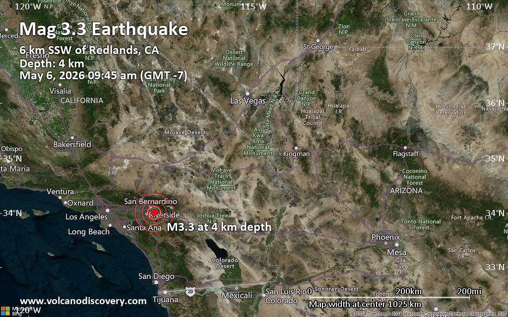 The United States Geological Survey reported a magnitude 3.3 quake in the United States near Moreno Valley, Riverside County, California, only 9 minutes ago. The earthquake hit in the morning on Wednesday, May 6th, 2026, at 9:45 am local time at a very shallow depth of 2.2 miles. The exact magnitude, epicenter, and depth of the quake might be revised within the next few hours or minutes as seismologists review data and refine their calculations, or as other agencies issue their report.
Our monitoring service identified a second report from The Incorporated Research Institutions for Seismology (IRIS) which listed the quake at magnitude 3.3 as well. A third agency, the European-Mediterranean Seismological Centre (EMSC), reported the same quake at magnitude 3.2.
Based on the preliminary seismic data, the quake should not have caused any significant damage, but was probably felt by many people as light vibration in the area of the epicenter.
Weak shaking might have been felt in Redlands (pop. 71,000) located 4 miles from the epicenter, Loma Linda (pop. 24,000) 4 miles away, Moreno Valley (pop. 204,200) 5 miles away, and Colton (pop. 54,600) 8 miles away.
Other towns or cities near the epicenter where the quake might have been felt as very weak shaking include Highland (pop. 54,900) located 8 miles from the epicenter, San Bernardino (pop. 216,100) 8 miles away, Riverside (pop. 317,300) 11 miles away, Rialto (pop. 103,100) 12 miles away, and Fontana (pop. 212,700) 14 miles away.
Earthquake data: Date & time: May 6, 2026 09:45 am (GMT -7) local time (6 May 2026 16:45 GMT)Magnitude: 3.3 Depth: 3.56 km Epicenter latitude / longitude: 34.01°N / 117.21°W  ( San Bernardino County, California, United States) Primary data source: USGShttps://www.volcanodiscovery.com/earthquake/news/301647/Small-magnitude-33-quake-hits-5-miles-northeast-of-Moreno-Valley-California-United-States-in-the-mor.html
|
|


CMS The Best Conveyancing solicitors conveyancing quotes throughout the UK
For any webhosting enquiries please email webmaster@aus-city.com
|
|
Entire Thread
|
 Small magnitude 3.3 quake hits 5 miles northeast of Moreno Valley, California, United States in the morning
|
Webmaster
|
Wed 06 May 2026 04:55:PM
|
|
Forums60
Topics792,808
Posts827,590
Members2,960
| |
Most Online102,106
Jul 10th, 2026
|
|
|
|
|
Copyright 1996 - 2026 by David Cottle. Designed by David Bate Jr. All Rights Reserved.
By using this forum, the user agrees not to transfer any data or technical information received under this agreement to any other entity without the express approval of the AUS-CITY Forum Admins and/or authors of individual posts (Forum Admins and DoD/USSPACECOM for the analysis of satellite tracking data).
Two-line elements (TLE) and all other satellite data presented and distributed via this forum and AUS-CITY mailing lists are distributed with permission from DoD/USSTRATCOM.

|

|


 - Click image for larger picture.")


