|
0 members (),
1,498
guests, and
27
robots. |
|
Key:
Admin,
Global Mod,
Mod
|
|
S |
M |
T |
W |
T |
F |
S |
|
|
|
|
|
1
|
2
|
3
|
|
4
|
5
|
6
|
7
|
8
|
9
|
10
|
|
11
|
12
|
13
|
14
|
15
|
16
|
17
|
|
18
|
19
|
20
|
21
|
22
|
23
|
24
|
|
25
|
26
|
27
|
28
|
29
|
30
|
31
|
|
There are no members with birthdays on this day. |
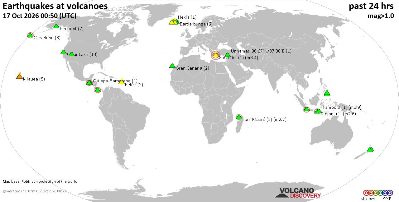
Volcano earthquake report for Saturday, 17 October 2026
• M 7.7 - 12 km WSW of Pitaloza Arriba, Panama
• M 4.6 - 194 km SSE of Vilyuchinsk, Russia
• M 0.0 - 19 km E of Finley Point, Montana
• M 3.6 - 2 km NW of Knik, Alaska
• M 0.9 - 12 km ESE of Lincoln, Montana
|

#812426
Wed 20 May 2026 12:33:PM
|
Joined: Feb 2001
Posts: 678,977
Launch Director
|
|
Launch Director
Joined: Feb 2001
Posts: 678,977 |
SPC MD 800MD 0800 CONCERNING SEVERE POTENTIAL...WATCH UNLIKELY FOR PORTIONS OF THE OHIO VALLEY 
Mesoscale Discussion 0800
NWS Storm Prediction Center Norman OK
0650 AM CDT Wed May 20 2026

Areas affected...portions of the Ohio Valley

Concerning...Severe potential...Watch unlikely

Valid 201150Z - 201345Z

Probability of Watch Issuance...5 percent

SUMMARY...Thunderstorms will continue moving east-northeast this
morning, with additional thunderstorms likely to develop. The
overall environment should limit hail potential this morning, but
may become favorable for isolated damaging winds. A watch is
currently not expected.

DISCUSSION...Showers and thunderstorms are ongoing this morning
across portions of the Ohio Valley, along and south of a surface
cold front. This region is beneath modest deep-layer ascent
associated with an anticyclonically curved 140-knot upper-level jet
north of the Great Lakes per objective analyses. These showers and
thunderstorms are expected to continue moving northeast, embedded
within broad southwest flow.

The overall thermodynamic environment this morning is rather poor,
with objectively analyzed MUCAPE values generally less than 250
J/kg, and the kinematic fields are not much better, with
effective-layer shear generally less than 30 knots. However, the
environment is very moist, with objectively analyzed PW values
ranging from 1.5 to 1.7 inches this morning.

Thunderstorm intensity should gradually increase this morning with
diurnal heating. Midlevel lapse rates are generally poor across the
region which should limit any hail potential, but as low-level lapse
rates steepen with daytime heating an isolated damaging wind gust
cannot be ruled out.

Although the potential for isolated damaging wind gusts will
increase later this morning and afternoon along and ahead of these
developing storms, the potential should remain very isolated for the
next couple of hours. Thus, a watch is not expected in the near
term.

..Marsh/Gleason.. 05/20/2026

...Please see www.spc.noaa.gov for graphic product...

ATTN...WFO...RNK...PBZ...RLX...CLE...JKL...ILN...LMK...

LAT...LON   40088338 40998209 40678059 40147998 39127977 38148001
            37438156 37128289 37328424 37508496 38878467 40088338

MOST PROBABLE PEAK WIND GUST...55-70 MPH
MOST PROBABLE PEAK HAIL SIZE...UP TO 1.25 IN
Read morehttps://www.spc.noaa.gov/products/md/md0800.html
|
|



CMS The Best Conveyancing solicitors conveyancing quotes throughout the UK
For any webhosting enquiries please email webmaster@aus-city.com
|
|
Entire Thread
|
 SPC MD 800
|
Webmaster
|
Wed 20 May 2026 12:33:PM
|
|
Forums60
Topics880,233
Posts915,030
Members2,960
| |
Most Online102,106
Jul 10th, 2026
|
|
|









































