|
|
|
1 members (Alisa),
1,643
guests, and
254
robots. |
|
Key:
Admin,
Global Mod,
Mod
|
|
S |
M |
T |
W |
T |
F |
S |
|
|
|
|
1
|
2
|
3
|
4
|
|
5
|
6
|
7
|
8
|
9
|
10
|
11
|
|
12
|
13
|
14
|
15
|
16
|
17
|
18
|
|
19
|
20
|
21
|
22
|
23
|
24
|
25
|
|
26
|
27
|
28
|
29
|
30
|
31
|
|
|
There are no members with birthdays on this day. |
|
|
|
|
|
|
|
|
|
|
|
|
Mini-Heap
by Alisa - Wed 22 Jul 2026 01:04:PM
|
|
|
|
|
|
|
|
|
|
|

Volcano earthquake report for Friday, 10 Jul 2026
• Moderate mag. 4.2 earthquake - 133 km northwest of Ternate, Kota Ternate, N...
• World Earthquake Report for Friday, 10 July 2026
• Moderate mag. 4.6 earthquake - 17 km southwest of Comalapa, Estado de Chiap...
• Moderate mag. 4.1 earthquake - Olyutorskiy Rayon, 47 km northwest of Tilich...
• Moderate mag. 4.0 earthquake - Hawke's Bay, New Zealand, on Saturday, Jul 1...
|

#814521
Mon 01 Jun 2026 03:50:AM
|
Joined: Feb 2001
Posts: 678,976
Launch Director
|
OP

Launch Director
Joined: Feb 2001
Posts: 678,976 |
Volcano earthquake report for Monday, 1 Jun 2026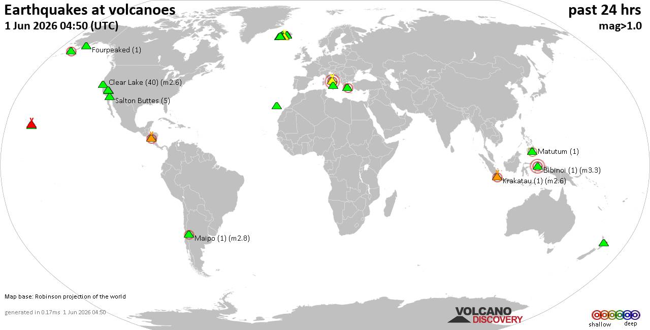 World map showing volcanoes with shallow (less than 50 km) earthquakes within 20 km radius during the past 24 hours on 1 Jun 2026 Number in brackets indicate nr of quakes. Quakes detected near: Bardarbunga (12 quakes between mag 0.0-1.9), Bibinoi (1 quake mag 3.3), Brennisteinsfjöll (10 quakes between mag 0.0-1.2), Campi Flegrei (Phlegrean Fields) (20 quakes between mag 0.1-3.0), Clear Lake (40 quakes between mag 0.3-2.6), Coso (2 quakes between mag 1.0-1.4)
Eldey (7 quakes between mag 0.6-1.7), Fourpeaked (1 quake mag 1.1), Golden Trout Creek (1 quake mag 1.0), Grímsnes (2 quakes between mag 0.6-1.4), Hekla (2 quakes between mag 0.2-1.5), Hengill (27 quakes between mag 0.0-1.3), Hrómundartindur (161 quakes between mag 0.0-2.9), Katla (11 quakes between mag 0.0-2.4), Kilauea (2 quakes between mag 1.7-1.8), Krakatau (1 quake mag 2.6), Krísuvík (5 quakes between mag 0.2-1.4), La Palma (1 quake mag 1.7), Lipari (1 quake mag 1.8), Loihi (1 quake mag 2.2), Loki-Fögrufjöll volcano (1 quake mag 1.0), Maipo (1 quake mag 2.8), Matutum (1 quake mag 2.4), Methana (1 quake mag 2.1), Poco Leok (1 quake mag 2.0), Prestahnukur (20 quakes between mag 0.7-2.0), Reporoa (1 quake mag 1.7), Salton Buttes (5 quakes between mag 1.2-1.6), San Cristobal (1 quake mag 2.8), Santo Tomas (1 quake mag 3.7), Stepovak Bay 4 (1 quake mag 2.0), Vatnafjöll (2 quakes between mag 0.5-1.1) (updated 03h50)
Note: Earthquakes within 20 km from and at depths less than 50 km under active volcanoes are reported. The list is not complete because many volcanoes are not monitored and/or seismic data in high resolution is not available publicly.
Volcanoes with recent earthquakes above magnitude 2 or more than 10 quakes are listed below:
Bardarbunga volcano (Iceland): 12 earthquakes up to magnitude 1.9Possible earthquake swarm: 12 earthquakes occurred near (under) the volcano during 17 hours, the last being recorded quake 3 hours ago. Hypocenter depths ranged between 12.80 and 0.00 km. Earthquake details: (only 5 largest) 1.9 quake 6.7 km ENE of Bárðarbunga May 31, 2026 07:01 am (Universal Time) (8 km ENE) 1.5 quake 6.4 km ENE of Bárðarbunga May 31, 2026 10:00 am (Universal Time) (7 km ENE) 1.2 quake 3.8 km SW of Bárðarbunga May 31, 2026 12:31 pm (Universal Time) (2 km SW) 1.1 quake Iceland: 4.6 km SE of Bárðarbunga Jun 1, 2026 12:26 am (Reykjavik time) (4 km ESE) 0.7 quake Iceland: 7.4 km E of Bárðarbunga May 31, 2026 10:27 am (Reykjavik time) (8 km ENE) All earthquakes at BardarbungaBibinoi volcano (Halmahera): magnitude 3.3 earthquakeA magnitude 3.3 earthquake occurred at the volcano 15 hours ago. The quake, which might be volcanic in origin, was located at a depth of 5.00 km depth at 19 km distance WNW from the volcano. Earthquake details: 3.3 quake 13 km southeast of Labuha, Kabupaten Halmahera Selatan, North Maluku, Indonesia, May 31, 2026 09:29 pm (GMT +9) (19 km WNW) All earthquakes at BibinoiCampi Flegrei (Phlegrean Fields) volcano (Italy): 20 earthquakes up to magnitude 3.0Possible earthquake swarm: 20 earthquakes occurred near (under) the volcano during 17 hours, the last being recorded quake 1 hour 55 minutes ago. Hypocenter depths ranged between 10.00 and 0.54 km. Earthquake details: (only 5 largest) Reported seismic-like event (likely no quake): 3.9 km north of Naples, Napoli, Campania, Italy, Jun 1, 2026 01:34 am (GMT +2) (12 km ENE) 1.9 quake 12 km west of Naples, Napoli, Campania, Italy, May 31, 2026 06:47 pm (GMT +2) (1 km WNW) 0.8 quake 4.4 km west of Fuorigrotta, Napoli, Campania, Italy, May 31, 2026 08:10 pm (GMT +2) (1 km ESE) 0.7 quake 2.3 km northwest of Bagnoli, Napoli, Campania, Italy, Jun 1, 2026 03:54 am (GMT +2) (1 km ESE) 0.6 quake Tyrrhenian Sea, 19 km northeast of Isola d'Ischia Island, Italy, May 31, 2026 04:54 pm (GMT +2) (4 km WSW) All earthquakes at Campi Flegrei (Phlegrean Fields)Clear Lake volcano (California): 40 earthquakes up to magnitude 2.6Possible earthquake swarm: 40 earthquakes occurred near (under) the volcano during 21 hours, the last being recorded quake 2 hours ago. Hypocenter depths ranged between 3.79 and 0.96 km. Earthquake details: (only 5 largest) 2.6 quake 27 mi north of Santa Rosa, Sonoma County, California, United States, May 31, 2026 01:33 pm (GMT -7) (18 km SSW) 2.1 quake Sonoma County, 14 mi southwest of Clearlake, Lake County, California, United States, May 31, 2026 06:41 am (GMT -7) (17 km S) 1.9 quake Sonoma County, 14 mi southwest of Clearlake, Lake County, California, United States, May 31, 2026 01:59 pm (GMT -7) (17 km S) 1.7 quake Sonoma County, 14 mi southwest of Clearlake, Lake County, California, United States, May 31, 2026 01:00 am (GMT -7) (17 km SSW) 1.6 quake 12 mi southwest of Clearlake, Lake County, California, United States, May 31, 2026 11:10 am (GMT -7) (15 km S) All earthquakes at Clear LakeHengill volcano (Iceland): 27 earthquakes up to magnitude 1.3Possible earthquake swarm: 27 earthquakes occurred near (under) the volcano during 17 hours, the last being recorded quake 4 hours ago. Hypocenter depths ranged between 20.90 and 0.00 km. Earthquake details: (only 5 largest) 1.3 quake 4.1 km SW of Eiturhóll May 31, 2026 07:12 pm (Universal Time) (11 km SW) 1.0 quake Iceland: 4.1 km WSW of Eiturhóll May 31, 2026 06:03 pm (Reykjavik time) (11 km SW) 0.9 quake Iceland: 3.6 km NNE of Eiturhóll May 31, 2026 06:31 pm (Reykjavik time) (4 km SW) 0.8 quake Iceland: 2.2 km NNW of Litla_Kaffistofan May 31, 2026 07:01 am (Reykjavik time) (15 km SW) 0.8 quake Iceland: 3.3 km SW of Eiturhóll May 31, 2026 07:58 pm (Reykjavik time) (10 km SW) All earthquakes at HengillHrómundartindur volcano (Iceland): 161 earthquakes up to magnitude 2.9Possible earthquake swarm: 161 earthquakes occurred near (under) the volcano during 21 hours, the last being recorded quake 20 minutes ago. Hypocenter depths ranged between 9.30 and 0.00 km. Earthquake details: (only 5 largest) 2.9 quake South, 23 km east of Reykjavik, Capital Region, Iceland, May 31, 2026 05:01 pm (Reykjavik time) (12 km W) 2.9 quake South, 22 km east of Reykjavik, Capital Region, Iceland, May 31, 2026 06:28 pm (Reykjavik time) (13 km W) 2.8 quake South, 22 km east of Reykjavik, Capital Region, Iceland, May 31, 2026 06:55 am (Reykjavik time) (13 km W) 2.6 quake 1.2 km ENE of Litla_Kaffistofan May 31, 2026 04:26 pm (Universal Time) (13 km W) 2.5 quake 2.1 km NE of Litla_Kaffistofan May 31, 2026 11:08 pm (Universal Time) (13 km W) All earthquakes at HrómundartindurKatla volcano (Iceland): 11 earthquakes up to magnitude 2.4Possible earthquake swarm: 11 earthquakes occurred near (under) the volcano during 17 hours, the last being recorded quake 4 hours ago. Hypocenter depths ranged between 6.00 and 0.00 km. Earthquake details: (only 5 largest) 2.4 quake Iceland: 7.6 km NNW of Goðabunga May 31, 2026 06:06 pm (Reykjavik time) (14 km NW) 2.0 quake Iceland: 7.6 km SSW of Hábunga May 31, 2026 09:17 am (Reykjavik time) (14 km SSW) 1.9 quake Iceland: 4.9 km NW of Hábunga May 31, 2026 09:17 am (Reykjavik time) (6 km WSW) 1.4 quake 4.8 km NNW of Hábunga May 31, 2026 09:19 am (Universal Time) (5 km WSW) 1.1 quake Iceland: 2.7 km NNW of Hábunga May 31, 2026 11:56 pm (Reykjavik time) (5 km SW) All earthquakes at KatlaKrakatau volcano (Sunda Strait): magnitude 2.6 earthquakeA magnitude 2.6 earthquake occurred at the volcano 8 hours ago. The quake, which might be volcanic in origin, was located at a depth of 10.00 km depth at 1 km distance NNW from the volcano. Earthquake details: 2.6 quake Indian Ocean, 18 km southwest of Pulau Sebesi Island, Lampung, Indonesia, Jun 1, 2026 03:14 am (GMT +7) (1 km NNW) All earthquakes at KrakatauLoihi volcano (Hawai'i (Big Island)): magnitude 2.2 earthquakeA magnitude 2.2 earthquake occurred at the volcano 20 hours ago. The quake, which might be volcanic in origin, was located at a depth of 29.95 km depth at 17 km distance NW from the volcano. Earthquake details: 2.2 quake North Pacific Ocean, 13 mi southeast of Pāhala, Hawaii County, Hawaii, United States, May 30, 2026 09:27 pm (GMT -10) (17 km NW) All earthquakes at LoihiMaipo volcano (Central Chile and Argentina): magnitude 2.8 earthquakeA magnitude 2.8 earthquake occurred at the volcano 13 hours ago. The quake, which might be volcanic in origin, was located at a depth of 15.60 km depth at 9 km distance SSW from the volcano. Earthquake details: 2.8 quake 96 km southeast of Puente Alto, Cordillera, Santiago Metropolitan, Chile, May 31, 2026 10:35 am (GMT -4) (9 km SSW) All earthquakes at MaipoMatutum volcano (Mindanao): magnitude 2.4 earthquakeA magnitude 2.4 earthquake occurred at the volcano 17 hours ago. The quake, which might be volcanic in origin, was located at a depth of 32.00 km depth at 2 km distance WNW from the volcano. Earthquake details: 2.4 quake 12 km northeast of Tupi, Province of South Cotabato, Soccsksargen, Philippines, May 31, 2026 06:22 pm (GMT +8) (2 km WNW) All earthquakes at MatutumMethana volcano (Greece): magnitude 2.1 earthquakeA magnitude 2.1 earthquake occurred at the volcano 23 hours ago. The quake, which might be volcanic in origin, was located at a depth of 2.00 km depth at 9 km distance SE from the volcano. Earthquake details: 2.1 quake Aegean Sea, 7.1 km northwest of Nisos Poros Island, Greece, May 31, 2026 08:18 am (GMT +3) (9 km SE) All earthquakes at MethanaPrestahnukur volcano (Iceland): 20 earthquakes up to magnitude 2.0Possible earthquake swarm: 20 earthquakes occurred near (under) the volcano during 13 hours, the last being recorded quake 9 hours ago. Hypocenter depths ranged between 14.10 and 0.00 km. Earthquake details: (only 5 largest) 2.0 quake Iceland: 14.6 km SSE of Húsafell May 31, 2026 05:23 pm (Reykjavik time) (10 km WSW) 1.8 quake 14.3 km N of Skjaldbreið May 31, 2026 05:46 am (Universal Time) (12 km SW) 1.8 quake 14.6 km SSE of Húsafell May 31, 2026 01:51 pm (Universal Time) (10 km WSW) 1.8 quake 14.6 km SSE of Húsafell May 31, 2026 07:29 am (Universal Time) (10 km WSW) 1.7 quake 14.7 km SSE of Húsafell May 31, 2026 05:39 am (Universal Time) (11 km WSW) All earthquakes at PrestahnukurSan Cristobal volcano (Nicaragua): magnitude 2.8 earthquakeA magnitude 2.8 earthquake occurred at the volcano 23 hours ago. The quake, which might be volcanic in origin, was located at a depth of 4.00 km depth at 5 km distance E from the volcano. Earthquake details: 2.8 quake 20 km northeast of Chinandega, Departamento de Chinandega, Nicaragua, May 30, 2026 11:12 pm (GMT -6) (5 km E) All earthquakes at San CristobalSanto Tomas volcano (Luzon Island): magnitude 3.7 earthquakeA magnitude 3.7 earthquake occurred at the volcano 24 hours ago. The quake, which might be volcanic in origin, was located at a depth of 10.00 km depth at 12 km distance SE from the volcano. Earthquake details: 3.7 quake 19 km south of Baguio, Philippines, May 31, 2026 11:58 am (GMT +8) (12 km SE) All earthquakes at Santo Tomashttps://www.volcanodiscovery.com/earthquakes-volcanoes/news/303849/Volcano-earthquake-report-for-Monday-1-Jun-2026.html
|
|


CMS The Best Conveyancing solicitors conveyancing quotes throughout the UK
For any webhosting enquiries please email webmaster@aus-city.com
|
|
Entire Thread
|
 Volcano earthquake report for Monday, 1 Jun 2026
|
Webmaster
|
Mon 01 Jun 2026 03:50:AM
|
|
Forums60
Topics790,237
Posts825,017
Members2,960
| |
Most Online102,106
Jul 10th, 2026
|
|
|
|
|
Copyright 1996 - 2026 by David Cottle. Designed by David Bate Jr. All Rights Reserved.
By using this forum, the user agrees not to transfer any data or technical information received under this agreement to any other entity without the express approval of the AUS-CITY Forum Admins and/or authors of individual posts (Forum Admins and DoD/USSPACECOM for the analysis of satellite tracking data).
Two-line elements (TLE) and all other satellite data presented and distributed via this forum and AUS-CITY mailing lists are distributed with permission from DoD/USSTRATCOM.

|

|


 - Click image for larger picture.")


