|
0 members (),
1,471
guests, and
52
robots. |
|
Key:
Admin,
Global Mod,
Mod
|
|
S |
M |
T |
W |
T |
F |
S |
|
|
|
|
|
|
|
1
|
|
2
|
3
|
4
|
5
|
6
|
7
|
8
|
|
9
|
10
|
11
|
12
|
13
|
14
|
15
|
|
16
|
17
|
18
|
19
|
20
|
21
|
22
|
|
23
|
24
|
25
|
26
|
27
|
28
|
29
|
|
30
|
31
|
|
|
|
|
|
|
There are no members with birthdays on this day. |
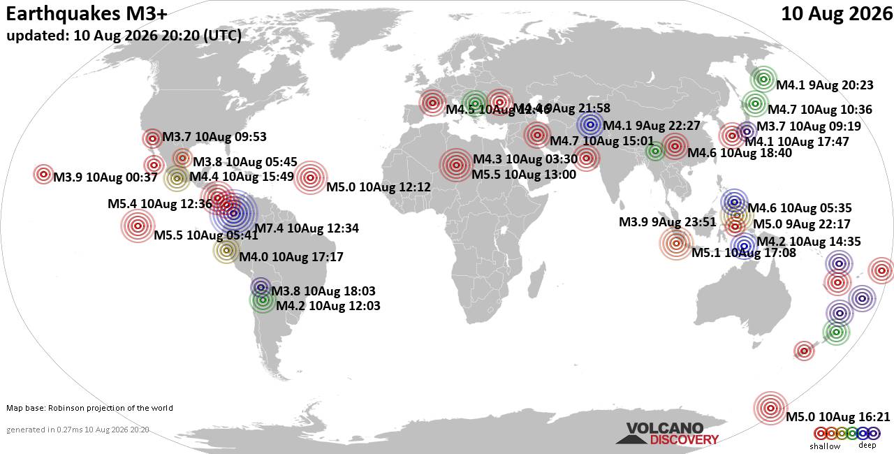
World Earthquake Report for Monday, 10 August 2026
• Volcano earthquake report for Monday, 10 Aug 2026
• Moderate mag. 4.0 earthquake - Zangilan Rayon, 58 km southwest of Ganja, Ga...
• Moderate mag. 4.6 earthquake - 31 km northeast of Xunchang, Sichuan, China,...
• Moderate mag. 4.2 earthquake - New Zealand on Tuesday, Aug 11, 2026, at 06:...
• World Earthquake Report for August 2026
|

#832688
Mon 10 Aug 2026 10:03:PM
|
Joined: Feb 2001
Posts: 678,976
Launch Director
|
OP

Launch Director
Joined: Feb 2001
Posts: 678,976 |
SPC Day 3-8 Fire Weather OutlookSPC Day 3-8 Fire Weather Outlook 
Day 3-8 Fire Weather Outlook
NWS Storm Prediction Center Norman OK
0458 PM CDT Mon Aug 10 2026

Valid 121200Z - 181200Z

...Synopsis...
As weak troughing builds across the western CONUS, high pressure
over the Four Corners will gradually translate eastward and settle
in the Southeast this weekend. As a result, hot, dry, and breezy
conditions will promote fire concerns across portions of the
southern Plains, and contribute to the drying of fuels into the
Lower Mississippi Valley. As monsoonal moisture continues to advect
northward, daily chances for thunderstorms are expected throughout
in the Desert Southwest, Great Basin, and Colorado Rockies. Mid to
late week, weak troughing over the West and a shortwave trough
approaching the Pacific Northwest should encourage thunderstorms and
wetting rain potential across much of the Rocky Mountain chain into
the High Plains.

...Days 3-4/Wednesday-Thursday...
...Northeastern Washington, Idaho Panhandle, and northwestern
Montana...
A shortwave trough will impinge upon the Pacific Northwest and
northern Rockies with an accompanying plume of moisture. Ensemble
guidance depicts sufficient instability across the region amid
stronger southwesterly flow aloft, promoting greater thunderstorm
potential. Given a prolonged dry airmass and very receptive fuels,
lightning ignitions are possible where favorable rainfall
accumulations are unlikely. Recent guidance indicates higher
probabilities of accumulating rainfall (0.5" or greater) in central
to eastern Montana. As such, 10% Dry Thunderstorm probabilities have
been confined to where less precipitation efficiency is expected,
and forecast ERCs remain at the 80-95th percentiles. While much
desired rainfall is forecast across portions of the northern Rockies
through the weekend, it is worth noting the exceptionally dry
fuelscape will be sensitive to lightning ignitions, even in areas
not outlined by dry thunderstorm probabilities.

...Northern California...
Troughing should settle over the western CONUS on Day 3/Wednesday as
the Four Corners high shifts eastward. Monsoonal moisture will
advect northward, combining with daytime instability to generate
5-10% probabilities of isolated afternoon thunderstorms. Some
potential exists for nocturnal convection west of the Sierra Crest
on Day 3/Wednesday night into Day 4/Thursday morning; however,
varying model guidance precludes probabilities at this time. On Day
4/Thursday, ensembles indicate more sufficient instability and
higher cloud bases in the northern California higher
terrain/adjacent foothills, enhancing concerns for lightning-induced
ignitions within the receptive fuelscape. As such, 10% Dry
Thunderstorm probabilities have been maintained.

...Southern High Plains...
High pressure will center over the Central U.S. on Day 4/Wednesday,
and will continue to slide eastward through the forecast period.
Hot, dry, and breezy conditions will persist across portions of
western Oklahoma, the TX/OK Panhandles, and southwestern Kansas
where fuels are growing increasingly receptive. 40% Critical
probabilities remain on Days 3-4/Wednesday-Thursday, and were
introduced on Day 5/Friday.

..Elizalde-Garcia.. 08/10/2026

...Please see www.spc.noaa.gov/fire for graphic product...
Read morehttps://www.spc.noaa.gov/products/exper/fire_wx/
|
|



CMS The Best Conveyancing solicitors conveyancing quotes throughout the UK
For any webhosting enquiries please email webmaster@aus-city.com
|
|
Entire Thread
|
 SPC Day 3-8 Fire Weather Outlook
|
Webmaster
|
Mon 10 Aug 2026 10:03:PM
|
|
Forums60
Topics795,967
Posts830,757
Members2,960
| |
Most Online102,106
Jul 10th, 2026
|
|
|





































