|
0 members (),
1,435
guests, and
23
robots. |
|
Key:
Admin,
Global Mod,
Mod
|
|
S |
M |
T |
W |
T |
F |
S |
|
|
|
|
|
1
|
2
|
3
|
|
4
|
5
|
6
|
7
|
8
|
9
|
10
|
|
11
|
12
|
13
|
14
|
15
|
16
|
17
|
|
18
|
19
|
20
|
21
|
22
|
23
|
24
|
|
25
|
26
|
27
|
28
|
29
|
30
|
31
|
|
There are no members with birthdays on this day. |
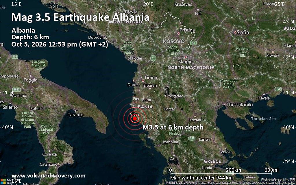
Magnitude 3.5 earthquake strikes near Vlore, Bashkia Vlorë, Qarku i Vlores, Albania
• M 2.1 - 2 km S of Forest Park, Georgia
• M 5.0 - Mariana Islands region
• M 1.2 - 10 km WSW of Shamrock, Oklahoma
• M 3.5 - 137 km NNE of Vieques, Puerto Rico
• M 2.1 - 69 km NE of Chignik, Alaska
• M 5.0 - 187 km ENE of Saipan, Northern Mariana Islands
|

#850066
Thu 27 Aug 2026 05:58:AM
|
Joined: Feb 2001
Posts: 678,977
Launch Director
|
|
Launch Director
Joined: Feb 2001
Posts: 678,977 |
SPC Aug 27, 2026 0600 UTC Day 1 Convective OutlookSPC 1200Z Day 1 Outlook 
Day 1 Convective Outlook
NWS Storm Prediction Center Norman OK
1255 AM CDT Thu Aug 27 2026

Valid 271200Z - 281200Z

...THERE IS A SLIGHT RISK OF SEVERE THUNDERSTORMS ACROSS PARTS OF
THE MID-ATLANTIC AND NORTHEAST...AND ALSO ACROSS PARTS OF
WESTERN/CENTRAL NE INTO NORTHWEST KS...

...SUMMARY...
Scattered strong to severe thunderstorms are possible across parts
of the Northeast today. Damaging wind, hail and a tornado or two may
accompany these storms. Large to very large hail and severe gusts
are also possible across parts of western Nebraska and northwest
Kansas.

...Mid-Atlantic/Northeast into parts of the central/southern
Appalachians...
An upper trough will remain in place over much of the eastern CONUS
today. Moderate destabilization will be possible along/ahead of a
weak surface trough/front extending from central NY/PA into the
central/southern Appalachians. Scattered thunderstorm development is
expected by mid/late afternoon, with sufficient deep-layer
flow/shear for some storm organization (especially from the northern
Mid-Atlantic into the Northeast). The strongest cells/clusters will
be capable of producing scattered damaging winds and at least
isolated hail. Modestly enlarged low-level hodographs may also
support some brief-tornado potential. Some severe threat may persist
into the evening before storms weaken and/or move offshore.

Father south, deep-layer flow/shear will be weaker into parts of the
central/southern Appalachians, but scattered storm development
within a relatively warm and well-mixed environment will support
potential for localized strong/damaging gusts.

...Central Plains...
Moderate to locally strong destabilization is expected across parts
of the central High Plains this afternoon, beneath modest
northwesterly mid/upper-level flow. While large-scale ascent will
generally remain rather modest, a subtle midlevel vorticity maximum
may aid in isolated to widely scattered storm development from far
southwest SD into western/central NE. Deep-layer shear will be
sufficient for supercells, with steep lapse rates and relatively
elongated hodographs supporting potential for large to very large
hail, in addition to a threat for localized severe gusts. 00Z CAM
guidance shows some uptick in storm coverage within this favorable
environment, and a 15% hail area has been added for parts of
west-central NE into northwest KS. Some guidance (notably the 00Z
HRRR) also shows upscale growth and an attendant swath of
severe-wind potential, though this scenario remains more uncertain.
Greater wind probabilities may eventually be needed if confidence
increases in the MCS scenario.

Surrounding the Level-2/Slight Risk, a more isolated threat of
severe hail and wind may accompany the strongest cells from parts of
the Raton Mesa and CO Front Range vicinity into eastern WY.

...Western/central Montana...
Despite rather limited low-level moisture, widely scattered storm
development is expected this afternoon across parts of
western/central MT, aided by strong heating and the influence of a
midlevel shortwave trough and jet maximum that are forecast to crest
the amplified upper ridge that is covering much of the interior
West. Steep lapse rates will support potential for localized
downbursts and strong to severe outflow gusts as storms spread
east-northeastward across MT.

...Northeast NV/northwest UT/southeast ID...
High-based storm development is also expected from parts of
northeast NV into northwest UT and southeast ID. While deep-layer
flow and storm organization will likely be somewhat weaker compared
to areas farther north, steep lapse rates and large DCAPE will
support potential for strong to severe outflow gusts from this
afternoon into the early evening.

...South-central TX into the LA Gulf Coast region...
Uncertainty remains regarding how far south an ongoing storm cluster
and its attendant outflow will move across parts of LA/MS early this
morning. If this cluster persists to the beginning of the forecast
period (as forecast by the 00Z HRRR), then a localized wind-damage
threat will be possible near the immediate LA/MS Gulf Coast before
storms move offshore. If the cluster weakens and more substantial
recovery and diurnal destabilization occurs later today (as forecast
by more recent HRRR runs and some other HREF members), then storm
redevelopment will be possible by afternoon, potentially aided by a
remnant MCV. This scenario could also result in a localized
wind-damage threat.

Farther west, scattered storm development is forecast across
south-central TX this afternoon, near a weak southward-moving cold
front. Deep-layer shear will likely remain quite weak, but moderate
buoyancy, large PW, and steep low-level lapse rates will support
potential for localized downbursts. Despite the weak shear, the
northerly flow regime may result in one or more outflow-driven
clusters that will move southward into the early evening before
weakening.

..Dean/Weinman.. 08/27/2026
Read morehttps://www.spc.noaa.gov/products/outlook/day1otlk_1200.html
|
|



CMS The Best Conveyancing solicitors conveyancing quotes throughout the UK
For any webhosting enquiries please email webmaster@aus-city.com
|
|
Entire Thread
|
 SPC Aug 27, 2026 0600 UTC Day 1 Convective Outlook
|
Webmaster
|
Thu 27 Aug 2026 05:58:AM
|
|
Forums60
Topics857,689
Posts892,484
Members2,960
| |
Most Online102,106
Jul 10th, 2026
|
|
|









































