|
|
|
0 members (),
1,957
guests, and
28
robots. |
|
Key:
Admin,
Global Mod,
Mod
|
|
S |
M |
T |
W |
T |
F |
S |
|
|
|
1
|
2
|
3
|
4
|
5
|
|
6
|
7
|
8
|
9
|
10
|
11
|
12
|
|
13
|
14
|
15
|
16
|
17
|
18
|
19
|
|
20
|
21
|
22
|
23
|
24
|
25
|
26
|
|
27
|
28
|
29
|
30
|
|
|
|
|
There are no members with birthdays on this day. |
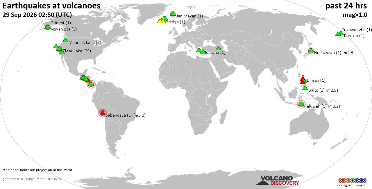
Volcano earthquake report for Tuesday, 29 September 2026
• M 1.0 - 7 km NW of The Geysers, CA
• M 1.8 - 57 km S of Whites City, New Mexico
• M 1.8 - 57 km S of Whites City, New Mexico
• M 2.2 - 8 km W of Cotati, CA
• M 3.5 - 184 km SE of Perryville, Alaska
|
|
|
Joined: Feb 2001
Posts: 678,977
Launch Director
|
|
Launch Director
Joined: Feb 2001
Posts: 678,977 |
SPC Sep 29, 2026 1930 UTC Day 3 Severe Thunderstorm OutlookSPC 1930Z Day 3 Outlook 
Day 3 Convective Outlook
NWS Storm Prediction Center Norman OK
0229 PM CDT Tue Sep 29 2026

Valid 011200Z - 021200Z

...THERE IS A MARGINAL RISK OF SEVERE THUNDERSTORMS ACROSS PARTS OF
THE SOUTHERN PLAINS...

...SUMMARY...
Widely scattered severe thunderstorms are possible Thursday
afternoon and evening across parts of the southern Plains.

...Synopsis...

An upper low over the southern High Plains Thursday morning is
expected to transition to a weakening trough extending from the
mid/lower MO Valley into the southern Plains by Thursday night.
During that break-down process, a series of vorticity maxima and an
associated belt of 40-50 kt mid-level flow will spread from the
southern Plains into the OH Valley. At the surface, an area of low
pressure will likewise weaken over south-central KS or north-central
OK ahead of a cold front settling south through the central Plains
and upper Midwest. The cold front will gradually overtake a
north-south-oriented Pacific front, which is forecast to stall over
the southern Plains.


...Southern Plains...

Spread exists across 12Z model guidance in the track of the upper
low, which will transition to an open wave on Thursday. The ECMWF in
particular has trended farther south with the primary vorticity lobe
emerging from the opening mid-level wave across OK. That scenario
leads to stronger forcing for ascent and vertical shear centered
over the Red River Valley, compared to prior model runs. However,
the potential for early-day storms leads to uncertainty in the
degree of air mass destabilization by afternoon within that region.
Confidence in more robust air mass destabilization increases with
southward extent, especially from portions of central TX into the
lower Rio Grande Valley, where vertical shear will be weaker. Given
these considerations, the Marginal-Risk probabilities have been
broadened over the Red River Valley to account for the conditional
risk for organized severe weather Thursday afternoon and evening. A
slight expansion of the Marginal-Risk probabilities was made over
the lower Rio Grande Valley to accommodate the potential for a
southeast-moving cluster of storms capable of sporadic damaging
winds Thursday afternoon and evening.


...Ozark Plateau into the OH Valley...

Both vertical shear and forcing for ascent are expected to increase
through the day, as highlighted in the synopsis. Considerable shower
and thunderstorm activity is anticipated along and ahead of the
front, which is expected to limit the degree of air mass
destabilization. However, where pockets of stronger heating can
occur, a strong to severe storm or two appears possible with the
primary hazard being damaging wind gusts. Confidence in where any
greater destabilization might occur currently remains too low to
include a Marginal-Risk probability contour.


...Central Kansas into northern Oklahoma...

As mentioned above, there is model variability in the track of the
mid-level wave and, by extension, the location of the surface low.
Nonetheless, a strong storm or two could develop Thursday afternoon
in the vicinity of the surface triple point, given sufficient air
mass destabilization.

..Mead.. 09/29/2026
Read morehttps://www.spc.noaa.gov/products/outlook/day3otlk_1930.html
|
|



CMS The Best Conveyancing solicitors conveyancing quotes throughout the UK
For any webhosting enquiries please email webmaster@aus-city.com
|
|
Entire Thread
|

 SPC Sep 29, 2026 1930 UTC Day 3 Severe Thunderstorm Outlook
|
Webmaster
|
3 hours ago
|
|
Forums60
Topics847,837
Posts882,632
Members2,960
| |
Most Online102,106
Jul 10th, 2026
|
|
|
|
|

|









































