|
1 members (Webmaster),
1,700
guests, and
25
robots. |
|
Key:
Admin,
Global Mod,
Mod
|
|
S |
M |
T |
W |
T |
F |
S |
|
1
|
2
|
3
|
4
|
5
|
6
|
7
|
|
8
|
9
|
10
|
11
|
12
|
13
|
14
|
|
15
|
16
|
17
|
18
|
19
|
20
|
21
|
|
22
|
23
|
24
|
25
|
26
|
27
|
28
|
|
29
|
30
|
|
|
|
|
|
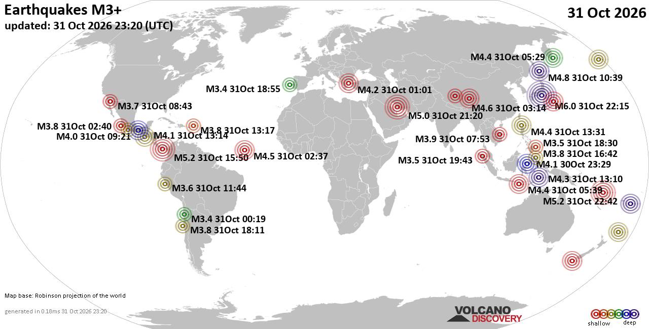
World Earthquake Report for Saturday, 31 October 2026
• M 2.4 - 6 km SW of Volcano, Hawaii
• M 3.1 - 10 km WSW of Hope, Alaska
• M 2.4 - 6 km SW of Volcano, Hawaii
• M 0.2 - 10 km N of Borrego Springs, CA
• M -0.7 - 61 km ENE of Pedro Bay, Alaska
• M 0.6 - 19 km NNE of Ridgecrest, CA
|

#889383
Fri 02 Oct 2026 02:37:AM
|
Joined: Feb 2001
Posts: 678,977
Launch Director
|
|
Launch Director
Joined: Feb 2001
Posts: 678,977 |
Issued at 500 PM HST Thu Oct 01 2026 000
WTPA42 PHFO 020237
TCDCP2
Tropical Storm Nolo Discussion Number 46
NWS Central Pacific Hurricane Center Honolulu HI EP152026
Issued by NWS National Hurricane Center Miami FL
500 PM HST Thu Oct 01 2026
Nolo continues to gradually become better organized. While
the storm's structure is still lacking across the southern
semicircle with drier air prevailing, deep convection is
re-igniting close to the center of circulation, displaced slightly
to the northwest. The latest subjective Dvorak intensity estimates
from JTWC and HFO rated Nolo at 45 and 55 kt, respectively, while
UW-CIMSS objective estimates show a wide spread of 29 to 50 kt.
With ASCAT data from around 2100 UTC showing max winds around 46
kt, and no significant changes occuring with Nolo's structure, the
initial intensity was held steady at 50 kt.
The initial motion was set at 310/10 kt. Nolo has nearly doubled in
speed over the last six hours. This is likely due high pressure
downstream of the system moving to Nolo's north, allowing the
cyclone to be picked up by stronger, subtropical steering flow.
Track guidance exhibits a fair amount of agreement on Nolo shifting
closer to due west over the next 24 to 48 hours, before turning back
to the west-northwest over the weekend while gaining forward speed.
Little was changed with the latest NHC track forecast compared to
the previous forecast.
Nolo is expected to enter a favorable environment defined by
warming SSTs and decreasing vertical wind shear. This will allow
for gradual restrengthening through much of the forecast period,
and Nolo may become a major hurricane as it approaches the
International Dateline. The latest NHC intensity forecast does
adjust Nolo's rate of strengthening heading into the weekend down
slightly, mostly as an effort to keep it more in line with the
guidance median, however Nolo's peak strength was raised slightly
to bring it more into agreement with HCCA guidance.
FORECAST POSITIONS AND MAX WINDS
INIT 02/0300Z 23.2N 166.3W 50 KT 60 MPH
12H 02/1200Z 23.4N 166.8W 55 KT 65 MPH
24H 03/0000Z 23.5N 168.3W 60 KT 70 MPH
36H 03/1200Z 23.5N 170.5W 65 KT 75 MPH
48H 04/0000Z 23.6N 173.7W 80 KT 90 MPH
60H 04/1200Z 24.1N 177.2W 95 KT 110 MPH
72H 05/0000Z 24.8N 179.6E 100 KT 115 MPH
96H 06/0000Z 26.3N 173.1E 105 KT 120 MPH
120H 07/0000Z 27.3N 165.5E 95 KT 110 MPH
$$
Forecaster Evans/Gibbs Source: Tropical Storm Nolo Forecast Discussion Number 46
|
|



CMS The Best Conveyancing solicitors conveyancing quotes throughout the UK
For any webhosting enquiries please email webmaster@aus-city.com
|
|
Entire Thread
|
 Tropical Storm Nolo Forecast Discussion Number 46 |
Webmaster
|
Fri 02 Oct 2026 02:37:AM
|
|
Forums60
Topics904,556
Posts939,353
Members2,960
| |
Most Online102,106
Jul 10th, 2026
|
|
|









































