|
|
|
0 members (),
1,387
guests, and
28
robots. |
|
Key:
Admin,
Global Mod,
Mod
|
|
S |
M |
T |
W |
T |
F |
S |
|
|
|
|
|
1
|
2
|
3
|
|
4
|
5
|
6
|
7
|
8
|
9
|
10
|
|
11
|
12
|
13
|
14
|
15
|
16
|
17
|
|
18
|
19
|
20
|
21
|
22
|
23
|
24
|
|
25
|
26
|
27
|
28
|
29
|
30
|
31
|
|
There are no members with birthdays on this day. |
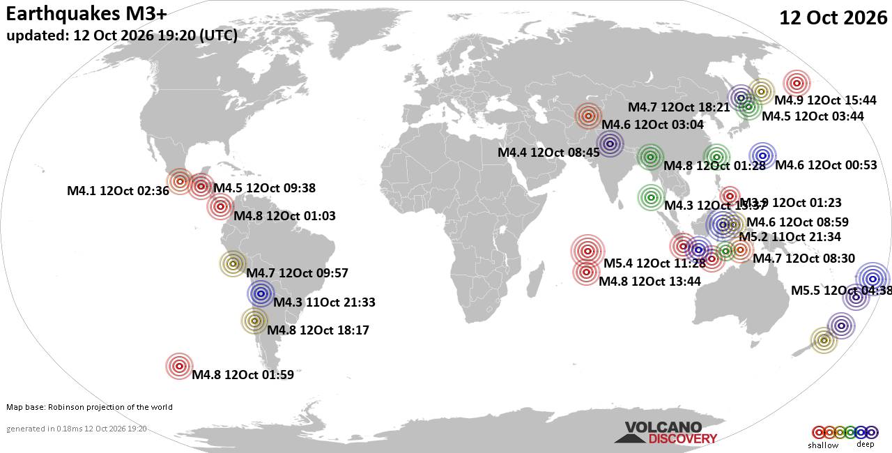
World Earthquake Report for Monday, 12 October 2026
• M 0.9 - 15 km NE of Milford, Utah
• M 1.6 - 9 km E of Ninilchik, Alaska
• M -0.7 - 69 km WNW of Tyonek, Alaska
• M 2.3 - 49 km SSE of Denali National Park, Alaska
• M 1.3 - 16 km NE of Milford, Utah
• M 2.5 - 20 km E of Markleeville, CA
|
|
|
Joined: Feb 2001
Posts: 678,977
Launch Director
|
|
Launch Director
Joined: Feb 2001
Posts: 678,977 |
SPC Oct 12, 2026 1930 UTC Day 3 Severe Thunderstorm OutlookSPC 1930Z Day 3 Outlook 
Day 3 Convective Outlook
NWS Storm Prediction Center Norman OK
0204 PM CDT Mon Oct 12 2026

Valid 141200Z - 151200Z

...THERE IS A MARGINAL RISK OF SEVERE THUNDERSTORMS ACROSS PARTS OF
THE SOUTHERN PLAINS AND OZARKS...

...SUMMARY...
Isolated severe thunderstorms are possible across portions of the
southern Plains into the Ozark Plateau Wednesday afternoon and
evening.

...Southern Plains to the Ozark Plateau...

Enhanced southwesterly deep-layer flow will persist across the
region as an upper low develops east/northeast from the Southwest to
the central High Plains on Wednesday. Surface high pressure is
forecast to build eastward from the northern Plains to the Great
Lakes as a surface cold front sags southward from the Ohio Valley
into the southern Plains. Ahead of this boundary, rich boundary
layer moisture will be in place, characterized by surface dewpoint
in the mid 60s to mid 70s F. Showers and thunderstorms will likely
be ongoing Wednesday morning in the vicinity of the surface front,
and some downstream cloudiness will likely limit stronger heating
across portions of the warm sector. Nevertheless, pockets of
moderate instability are expected to develop from west TX toward the
Ozark Plateau. As vertical shear and large-scale ascent increase
during the afternoon, isolated strong to severe storms may develop
within these pockets of stronger heating and destabilization as the
surface front sags southward.

...Ohio Valley...

A moist airmass will be in place ahead of a southward-sagging cold
front. Stronger vertical shear and any appreciable large-scale
forcing will remain displaced from the warm sector across the Lower
OH Valley. Modest destabilization will support widely scattered
thunderstorm develop from the Mid-South into southern OH and parts
of KY through early evening. However, severe potential is more
uncertain, compared to portions of the Plains/Ozarks, with northeast
extent along the surface boundary given poor lapse rates, weaker
vertical shear and nebulous large-scale ascent.

..Leitman.. 10/12/2026
Read morehttps://www.spc.noaa.gov/products/outlook/day3otlk_1930.html
|
|



CMS The Best Conveyancing solicitors conveyancing quotes throughout the UK
For any webhosting enquiries please email webmaster@aus-city.com
|
|
Entire Thread
|

 SPC Oct 12, 2026 1930 UTC Day 3 Severe Thunderstorm Outlook
|
Webmaster
|
4 hours ago
|
|
Forums60
Topics871,370
Posts906,166
Members2,960
| |
Most Online102,106
Jul 10th, 2026
|
|
|
|
|

|









































