|
0 members (),
3,195
guests, and
16
robots. |
|
Key:
Admin,
Global Mod,
Mod
|
|
S |
M |
T |
W |
T |
F |
S |
|
1
|
2
|
3
|
4
|
5
|
6
|
7
|
|
8
|
9
|
10
|
11
|
12
|
13
|
14
|
|
15
|
16
|
17
|
18
|
19
|
20
|
21
|
|
22
|
23
|
24
|
25
|
26
|
27
|
28
|
|
29
|
30
|
|
|
|
|
|
|
There are no members with birthdays on this day. |
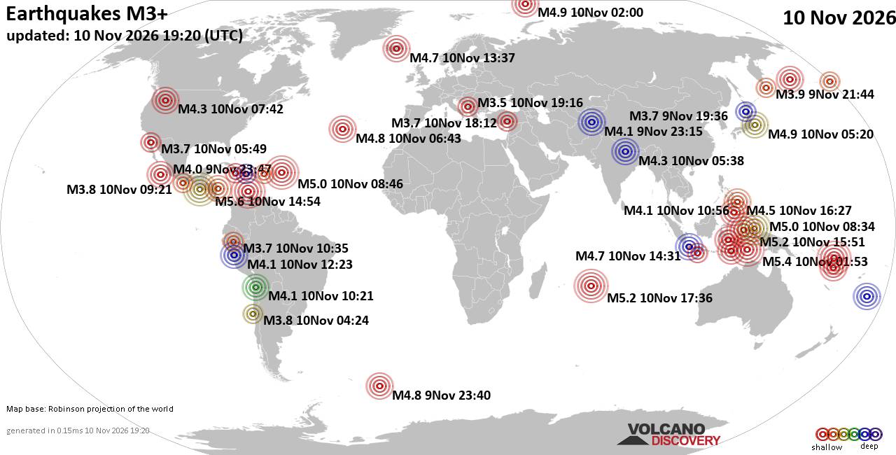
World Earthquake Report for Tuesday, 10 November 2026
• M 0.7 - 3 km SW of San Juan Bautista, CA
• Moderate mag. 4.1 earthquake - Philippine Sea, 52 km east of Siargao Island...
• M 1.3 - 15 km NNE of Milford, Utah
• M 2.0 - 37 km W of Petrolia, CA
• M 0.5 - 6 km SSW of Warner Springs, CA
• M 4.3 - 18 km SE of Joseph, Oregon
|

#915508
Fri 16 Oct 2026 02:56:PM
|
Joined: Feb 2001
Posts: 800,656
Launch Director
|
|
Launch Director
Joined: Feb 2001
Posts: 800,656 |
Issued at 900 AM CST Fri Oct 16 2026 000
WTPZ41 KNHC 161456
TCDEP1
Hurricane Trudy Discussion Number 13
NWS National Hurricane Center Miami FL EP212026
900 AM CST Fri Oct 16 2026
Satellite imagery shows that Trudy's intensification has again
paused, with the eye becoming less distinct and the convective cloud
tops in the eyewall becoming warmer. An earlier GPM microwave
overpass suggested that the eyewall has opened up on the south side,
possibly due to a tongue of dry air wrapping into that part of the
hurricane. The various satellite intensity estimates have changed
little since the last advisory, so the initial intensity is held at
105 kt. An Air Force Reserve Hurricane Hunter aircraft is scheduled
to investigate Trudy later today.
The initial motion is a somewhat erratic 335/4 kt, as Trudy has
followed its previous westward jog with a northward jog. A gradual
turn toward the northwest is likely during the next 24 hours as a
weak low-level to mid-level ridge builds over eastern Mexico. This
motion should continue through about 72 hours, with the center
passing near or over the coast of west-central Mexico at about the
48 hour point. After that time, a weakening Trudy should be steered
more by low-level flow. However, the guidance has some spread as to
which direction that should be. Some of the guidance shows a
west-northwest or west motion, while some models steer the cyclone
more northward due to the influence of a large deep-layer trough
over the northeastern Pacific. This part of the forecast track
splits the difference by showing a slow west-northwestward motion.
Overall, the new forecast track is similar to the previous track
through 60 hours, and then is a little to the north of the previous
track.
While the environment that Trudy is in seems to be conducive for
strengthening, the intensification has sputtered twice during the
past day or so. And in an interesting twist, the regional hurricane
models do not forecast any additional strengthening before the
hurricane reaches a less favorable environment. Other intensity
guidance suggest some intensification could still occur, and based
on a blend of this and the previous forecast the new intensity
forecast shows some strengthening during the next 24 hours. Trudy is
still expected to be a major hurricane as it approaches the coast of
Mexico. Later in the forecast period, Trudy is expected have land
interaction, move into a drier air mass, and encounter increasing
southwesterly shear. These factors should cause steady to rapid
weakening, and the new forecast follows the previous forecast in
showing the system as a post-tropical low by 120 h.
KEY MESSAGES:
1. Trudy is forecast to be a major hurricane when it approaches the
coast of southwestern and west-central Mexico this weekend, bringing
an increasing risk of storm surge, damaging winds, and flooding
rain. Hurricane Warnings and Watches, as well as Tropical Storm
Warnings and Watches, are currently in effect for portions of the
coast, and additional watches and warnings will likely be required
later today or tonight.
2. Heavy rainfall associated with Trudy will impact the southwest
Mexican coast between Guerrero and Jalisco through the weekend. This
rainfall may produce life-threatening flooding and mudslides by the
weekend along and near the southwest Mexican coast in Michoacán,
Colima, and Jalisco, especially in areas along steep terrain.
3. Large swells are affecting portions of the coast of southwestern
Mexico and will spread northward through the weekend, causing
life-threatening surf and rip current conditions.
FORECAST POSITIONS AND MAX WINDS
INIT 16/1500Z 14.6N 102.5W 105 KT 120 MPH
12H 17/0000Z 15.3N 102.9W 115 KT 130 MPH
24H 17/1200Z 16.6N 103.8W 120 KT 140 MPH
36H 18/0000Z 18.1N 104.8W 115 KT 130 MPH
48H 18/1200Z 19.6N 105.8W 100 KT 115 MPH
60H 19/0000Z 20.7N 106.4W 85 KT 100 MPH
72H 19/1200Z 21.2N 107.1W 65 KT 75 MPH
96H 20/1200Z 21.7N 108.1W 45 KT 50 MPH
120H 21/1200Z 22.2N 109.1W 30 KT 35 MPH...POST-TROP/REMNT LOW
$$
Forecaster Beven Source: Hurricane Trudy Forecast Discussion Number 13
|
|



CMS The Best Conveyancing solicitors conveyancing quotes throughout the UK
For any webhosting enquiries please email webmaster@aus-city.com
|
|
Entire Thread
|
 Hurricane Trudy Forecast Discussion Number 13 |
Webmaster
|
Fri 16 Oct 2026 02:56:PM
|
|
Forums60
Topics920,725
Posts955,522
Members2,960
| |
Most Online102,106
Jul 10th, 2026
|
|
|









































