|
|
|
0 members (),
1,731
guests, and
26
robots. |
|
Key:
Admin,
Global Mod,
Mod
|
|
S |
M |
T |
W |
T |
F |
S |
|
|
|
|
|
1
|
2
|
3
|
|
4
|
5
|
6
|
7
|
8
|
9
|
10
|
|
11
|
12
|
13
|
14
|
15
|
16
|
17
|
|
18
|
19
|
20
|
21
|
22
|
23
|
24
|
|
25
|
26
|
27
|
28
|
29
|
30
|
31
|
|
There are no members with birthdays on this day. |
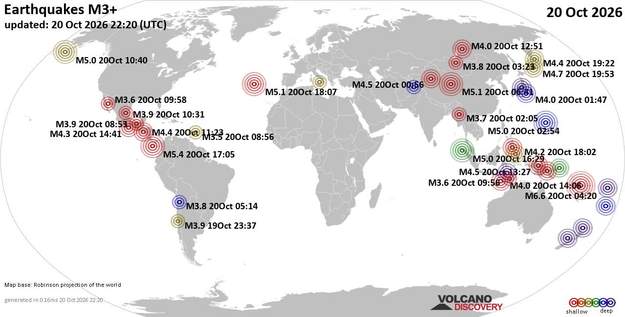
World Earthquake Report for Tuesday, 20 October 2026
• M 2.1 - 5 km SSW of Pāhala, Hawaii
• M 1.5 - 15 km NNE of Milford, Utah
• M 0.9 - 6 km WNW of Cobb, CA
• M 4.4 - 52 km S of Champerico, Guatemala
• M 1.9 - 8 km N of Redwood Valley, CA
|
|
|
Joined: Feb 2001
Posts: 678,977
Launch Director
|
|
Launch Director
Joined: Feb 2001
Posts: 678,977 |
SPC Oct 20, 2026 2000 UTC Day 1 Convective OutlookSPC 2000Z Day 1 Outlook 
Day 1 Convective Outlook
NWS Storm Prediction Center Norman OK
0255 PM CDT Tue Oct 20 2026

Valid 202000Z - 211200Z

...NO SEVERE THUNDERSTORM AREAS FORECAST...

...SUMMARY...
Organized severe thunderstorms are not expected through tonight.

...20z Update...
Isolated thunderstorm development is ongoing across portions of
southeastern AZ and southwestern NM where latest objective analysis
suggests MLCAPE has increased to around 500 J/kg amid diurnal
heating and mid-50s F surface dewpoints. While transient storm
organization and a low-probability risk for marginally severe hail
and/or locally strong gusts remain possible, the existing outlook
has been maintained owing to the expectation for any severe risk to
remain limited in magnitude and coverage. See the discussion below
for additional information.

..Chalmers.. 10/20/2026

.PREV DISCUSSION... /ISSUED 1125 AM CDT Tue Oct 20 2026/

...Southwest...
Beneath a belt of 30-40-kt southwesterly flow aloft, isolated to
widely scattered thunderstorm development is expected along the
higher terrain across parts of southeastern AZ into western NM this
afternoon. Diurnal heating amid middle/upper 50s dewpoints will
yield weak surface-based buoyancy, which combined with around 35 kt
of effective shear, may promote transient storm organization. While
an isolated instance of marginally severe hail (around 1 inch in
diameter) and/or locally strong gusts cannot be ruled out, the
overall severe threat is expected to remain isolated/limited today.

An increase in thunderstorm coverage is expected late in the period
across central/northern AZ as forcing for ascent strengthens within
the exit region of a robust midlevel jet. While deep-layer shear
will be increasing, most of this activity should remain elevated
amid weak buoyancy -- limiting the overall severe risk.
Read morehttps://www.spc.noaa.gov/products/outlook/day1otlk_2000.html
|
|



CMS The Best Conveyancing solicitors conveyancing quotes throughout the UK
For any webhosting enquiries please email webmaster@aus-city.com
|
|
Entire Thread
|

 SPC Oct 20, 2026 2000 UTC Day 1 Convective Outlook |
Webmaster
|
3 hours ago
|
|
Forums60
Topics885,562
Posts920,359
Members2,960
| |
Most Online102,106
Jul 10th, 2026
|
|
|
|
|

|









































