|
|
|
0 members (),
1,505
guests, and
26
robots. |
|
Key:
Admin,
Global Mod,
Mod
|
|
S |
M |
T |
W |
T |
F |
S |
|
1
|
2
|
3
|
4
|
5
|
6
|
7
|
|
8
|
9
|
10
|
11
|
12
|
13
|
14
|
|
15
|
16
|
17
|
18
|
19
|
20
|
21
|
|
22
|
23
|
24
|
25
|
26
|
27
|
28
|
|
29
|
30
|
|
|
|
|
|
|
There are no members with birthdays on this day. |
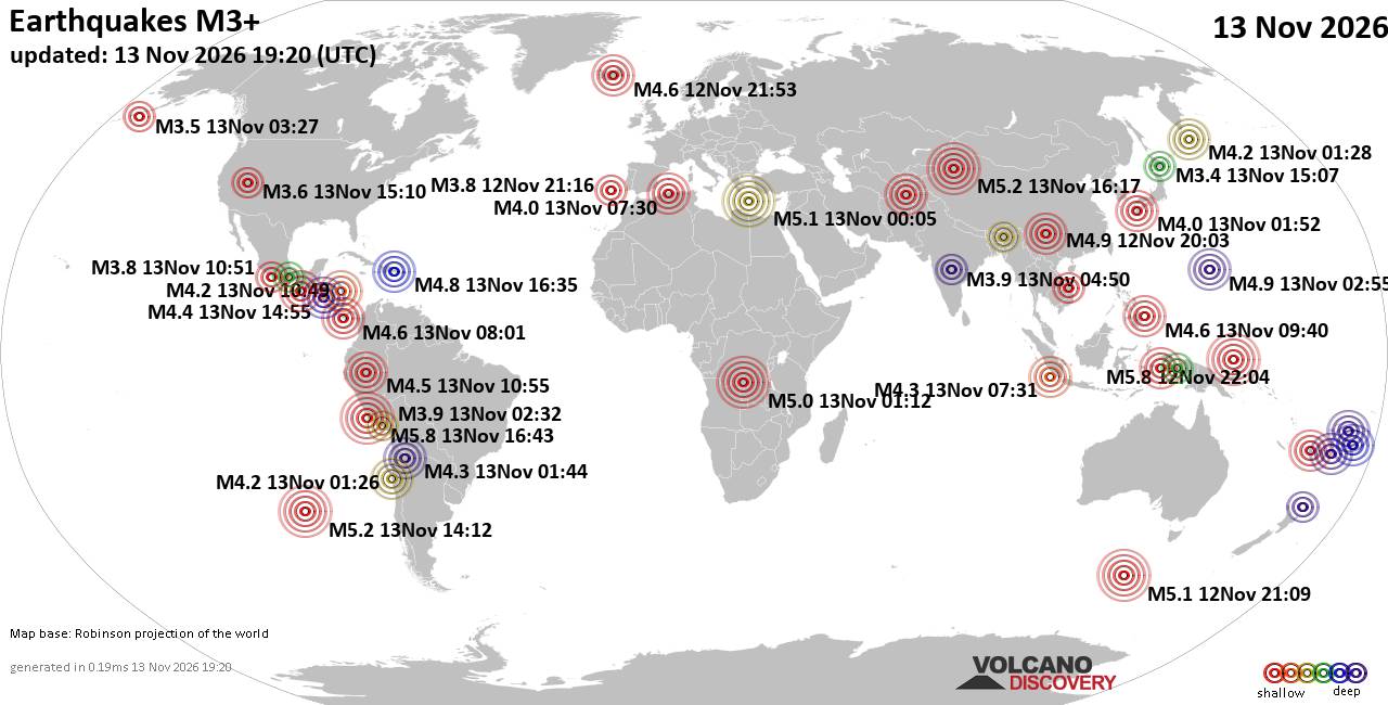
World Earthquake Report for Friday, 13 November 2026
• M 0.5 Other Event - 62 km ENE of Pedro Bay, Alaska
• M 0.5 Other Event - 64 km ENE of Pedro Bay, Alaska
• M 0.4 Other Event - 65 km ENE of Pedro Bay, Alaska
• M 4.5 - Mid-Indian Ridge
• M 0.4 Other Event - 63 km ENE of Pedro Bay, Alaska
• M 1.6 - 89 km NNW of Rachel, Nevada
|

#928176
Sat 24 Oct 2026 01:05:AM
|
Joined: Feb 2001
Posts: 800,656
Launch Director
|
|
Launch Director
Joined: Feb 2001
Posts: 800,656 |
SPC Oct 24, 2026 0100 UTC Day 1 Convective OutlookSPC 0100Z Day 1 Outlook 
Day 1 Convective Outlook
NWS Storm Prediction Center Norman OK
0802 PM CDT Fri Oct 23 2026

Valid 240100Z - 241200Z

...THERE IS A MARGINAL RISK OF SEVERE THUNDERSTORMS OVER PORTIONS OF
NEW MEXICO...SOUTHERN COLORADO AND FAR WEST TEXAS...

...SUMMARY...
Isolated severe thunderstorms with large hail, severe gusts, and
perhaps a tornado remain possible across portions of New Mexico,
southern Colorado, and Far West Texas this evening.

...New Mexico and Far West Texas...
Evening satellite imagery showed a broad upper trough over the Great
Basin and western US with a basal shortwave feature approaching the
Desert Southwest from northern Baja. Modest low-level moisture has
been advected northward ahead of these features supporting
destabilization over much of NM and Far West TX. This has resulted
in scattered thunderstorms from northern Mexico to southern CO this
afternoon and evening. Enhanced southerly mid-level flow of 40-50
kts has aided in organizing the storms into a mix of into supercells
and clusters with hail and severe gusts as the primary risk.

While sufficient for severe storms, the general environment is
expected to become less conducive through the remainder of this
evening with gradually decreasing buoyancy and favorable deep-layer
shear for organized storms. The onset of nocturnal cooling and
storms moving into a drier/more deeply mixed air mass farther east
across NM and Far West TX suggest the severe threat for severe gusts
and hail will become increasingly more isolated and focused tonight.

..Lyons.. 10/24/2026
Read morehttps://www.spc.noaa.gov/products/outlook/day1otlk_0100.html
|
|



CMS The Best Conveyancing solicitors conveyancing quotes throughout the UK
For any webhosting enquiries please email webmaster@aus-city.com
|
|
Entire Thread
|
 SPC Oct 24, 2026 0100 UTC Day 1 Convective Outlook |
Webmaster
|
Sat 24 Oct 2026 01:05:AM
|
|
Forums60
Topics926,339
Posts961,136
Members2,960
| |
Most Online102,106
Jul 10th, 2026
|
|
|
|
|

|









































