|
0 members (),
994
guests, and
23
robots. |
|
Key:
Admin,
Global Mod,
Mod
|
|
S |
M |
T |
W |
T |
F |
S |
|
|
|
|
|
1
|
2
|
3
|
|
4
|
5
|
6
|
7
|
8
|
9
|
10
|
|
11
|
12
|
13
|
14
|
15
|
16
|
17
|
|
18
|
19
|
20
|
21
|
22
|
23
|
24
|
|
25
|
26
|
27
|
28
|
29
|
30
|
31
|
|
There are no members with birthdays on this day. |
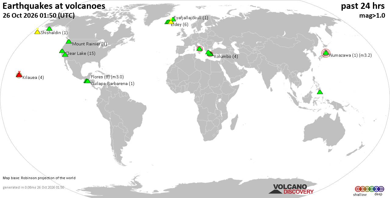
Volcano earthquake report for Monday, 26 October 2026
• M 4.6 - 193 km SE of Attu Station, Alaska
• M 1.3 - 62 km SW of Dugway, Utah
• M 0.7 - 1 km ENE of Calimesa, CA
• M 0.5 - 23 km ENE of Ashford, Washington
• M 1.7 - 14 km SSE of Fern Forest, Hawaii
• M 1.2 - 7 km ESE of Cloverdale, CA
|

#928380
Sat 24 Oct 2026 03:38:AM
|
Joined: Feb 2001
Posts: 678,977
Launch Director
|
|
Launch Director
Joined: Feb 2001
Posts: 678,977 |
Issued at 900 PM CST Fri Oct 23 2026 000
WTPZ42 KNHC 240338
TCDEP2
Hurricane Vance Discussion Number 11
NWS National Hurricane Center Miami FL EP222026
900 PM CST Fri Oct 23 2026
Correction: Updated to emphasize that Vance briefly reached major
hurricane intensity earlier this evening before weakening to
Category 2 strength.
Satellite imagery indicates that Vance became better organized
earlier this evening, with cloud-top temperatures cooling and deep
convection expanding around a warming eye. However, the eye has
become less distinct during the past hour or two, with some warming
of the cloud tops in the eyewall, possibly due to moderate southerly
vertical wind shear. The subjective Dvorak intensity estimate from
TAFB was T5.5/102 kt, although recent objective intensity estimates
have trended downward toward 95 kt. Vance briefly reached major
hurricane intensity earlier this evening before the recent
deterioration in its satellite presentation. Given the recent
degradation in satellite presentation and the latest objective
estimates, the initial intensity is set at 95 kt.
Vance is moving north-northwestward, or 345/6 kt. This general
motion is expected to continue during the next couple of days as a
broad mid- to upper-level trough evolves over the western portion of
the United States, weakening the subtropical ridge over Mexico.
Although the track guidance remains in relatively good agreement
through 24 to 36 h, forecast confidence decreases thereafter as the
trough shifts eastward and Vance enters a region of weaker steering
currents. Significant cross-track spread persists among the guidance
solutions, partly due to differences in how well Vance maintains its
vertical structure as increasing shear affects the cyclone. A
weaker, more vertically tilted system could be steered farther
westward, while a stronger, vertically coupled hurricane would be
more likely to continue northward toward the southwestern or
west-central coast of Mexico. Given these persistent differences,
the NHC track forecast remains largely unchanged from the previous,
lying close to the HCCA and GDMI aids.
Vance may have reached its peak intensity earlier this evening after
rapidly intensifying from 60 to 100 kt over the preceding 24 h.
Although some additional strengthening is possible in the short
term, recent satellite trends suggest that the hurricane may be
beginning to feel the effects of a less favorable environment.
Cooler sea surface temperatures associated with the wakes of recent
tropical cyclones have reduced the ocean heat content along portions
of Vance's forecast track. These cooler waters, combined with
increasing vertical wind shear, should contribute to a weakening
trend during the next day or two. However, the magnitude of
weakening remains uncertain and will depend partly on how long Vance
remains over the cooler waters. The aforementioned differences in
the track guidance have also contributed to considerable spread
among the intensity solutions, with the possibility of more
substantial weakening than currently forecast. Vance could move
beyond the cooler waters after 48 h, allowing for some
restrengthening. Thereafter, increasing vertical wind shear,
decreasing mid-level moisture, and possible land interaction should
lead to another weakening trend late in the forecast period. The NHC
intensity forecast remains similar to the previous prediction and
lies near the upper end of the guidance envelope through much of the
forecast period.
FORECAST POSITIONS AND MAX WINDS
INIT 24/0300Z 12.0N 102.6W 95 KT 110 MPH
12H 24/1200Z 12.8N 102.8W 105 KT 120 MPH
24H 25/0000Z 13.8N 103.1W 100 KT 115 MPH
36H 25/1200Z 14.8N 103.4W 90 KT 105 MPH
48H 26/0000Z 15.8N 103.8W 85 KT 100 MPH
60H 26/1200Z 16.3N 104.0W 90 KT 105 MPH
72H 27/0000Z 16.8N 104.2W 95 KT 110 MPH
96H 28/0000Z 17.6N 104.3W 85 KT 100 MPH
120H 29/0000Z 18.4N 104.4W 70 KT 80 MPH
$$
Forecaster Pierce/Gibbs Source: Hurricane Vance Forecast Discussion Number 11
|
|



CMS The Best Conveyancing solicitors conveyancing quotes throughout the UK
For any webhosting enquiries please email webmaster@aus-city.com
|
|
Entire Thread
|
 Hurricane Vance Forecast Discussion Number 11 |
Webmaster
|
Sat 24 Oct 2026 03:38:AM
|
|
Forums60
Topics895,174
Posts929,971
Members2,960
| |
Most Online102,106
Jul 10th, 2026
|
|
|









































