|
|
|
0 members (),
2,416
guests, and
26
robots. |
|
Key:
Admin,
Global Mod,
Mod
|
|
S |
M |
T |
W |
T |
F |
S |
|
1
|
2
|
3
|
4
|
5
|
6
|
7
|
|
8
|
9
|
10
|
11
|
12
|
13
|
14
|
|
15
|
16
|
17
|
18
|
19
|
20
|
21
|
|
22
|
23
|
24
|
25
|
26
|
27
|
28
|
|
29
|
30
|
|
|
|
|
|
|
There are no members with birthdays on this day. |
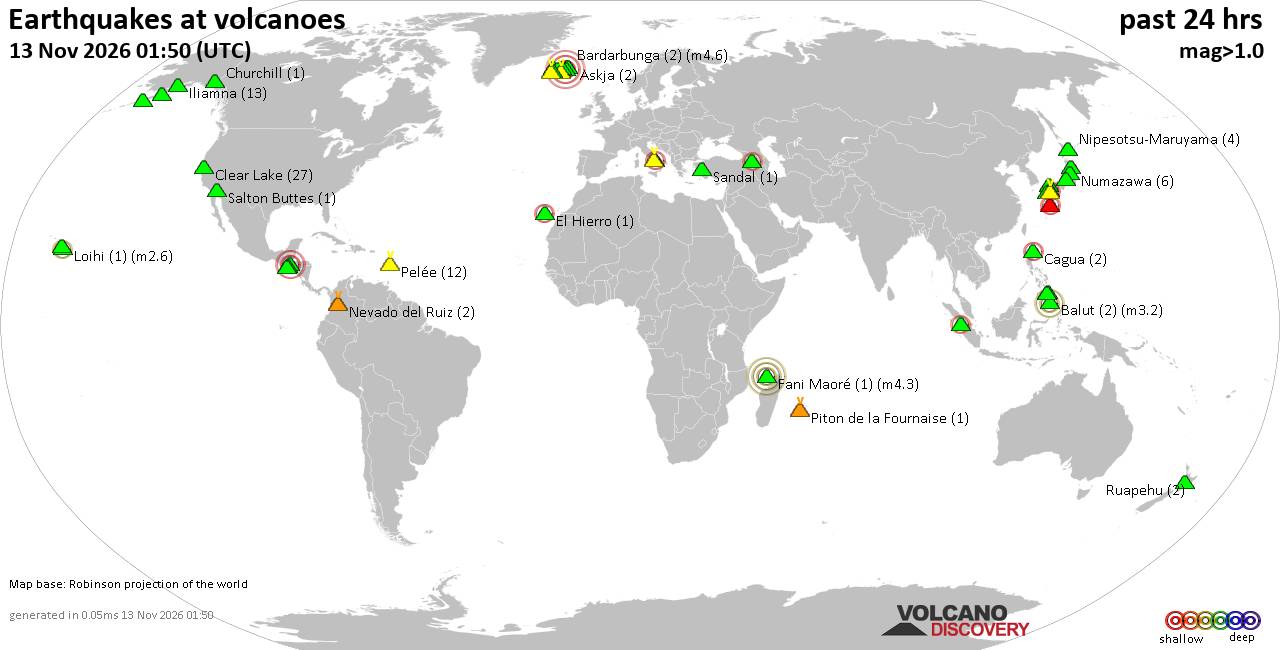
Volcano earthquake report for Friday, 13 November 2026
• M 3.4 - 54 km N of Kobuk, Alaska
• Moderate mag. 4.9 earthquake - Northern Mariana Islands: Mariana Islands on...
• M 1.6 - 28 km WSW of Salamatof, Alaska
• M -0.7 - 66 km ENE of Pedro Bay, Alaska
• M 0.6 - 89 km SE of Kokhanok, Alaska
• M 0.7 - 90 km SE of Kokhanok, Alaska
|

#929609
Sun 25 Oct 2026 02:50:AM
|
Joined: Feb 2001
Posts: 800,656
Launch Director
|
|
Launch Director
Joined: Feb 2001
Posts: 800,656 |
Volcano earthquake report for Sunday, 25 October 2026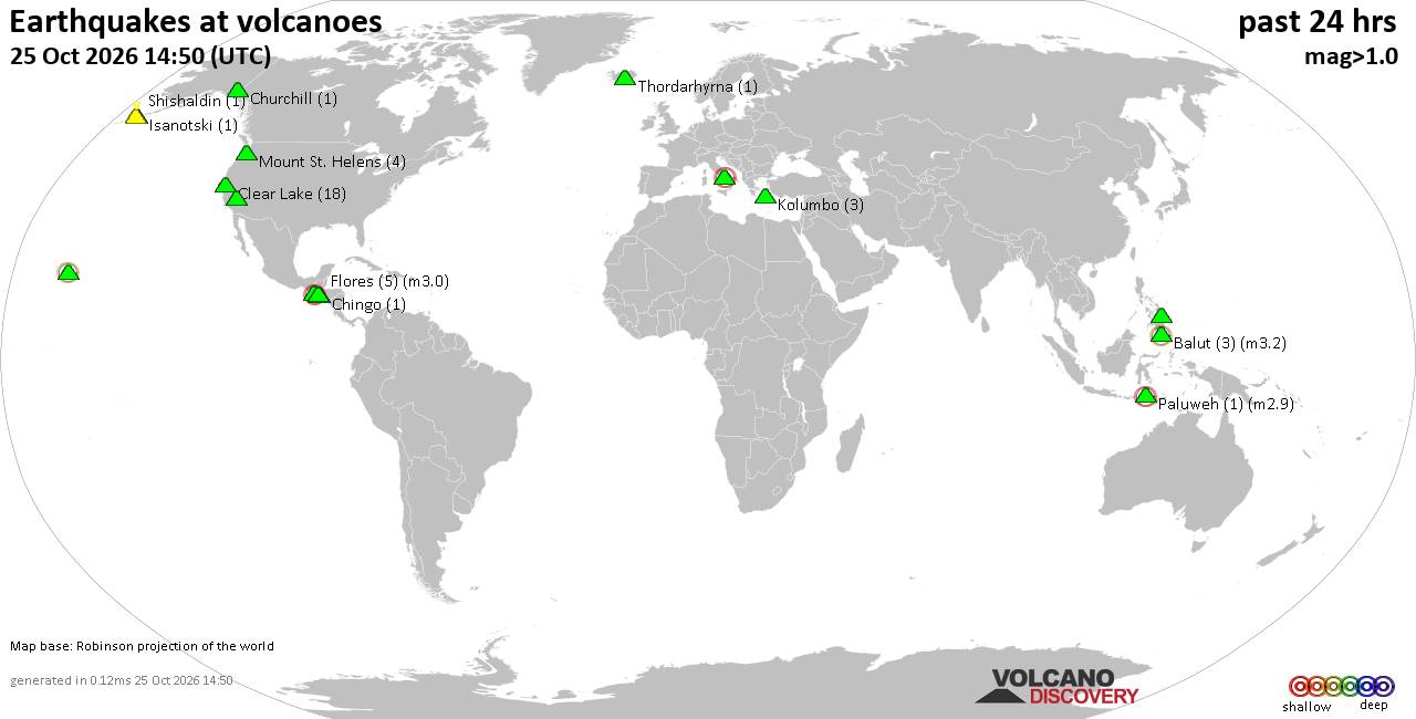 World map showing volcanoes with shallow (less than 50 km) earthquakes within 20 km radius during the past 24 hours on 25 Oct 2026 Number in brackets indicate nr of quakes. Quakes detected near: Agua (2 quakes between mag 1.4-1.8), Apaneca Range (1 quake mag 1.5), Arenal (1 quake mag 2.0), Balintang (1 quake mag 4.7), Balut (2 quakes between mag 1.8-3.2), Barva (3 quakes between mag 1.0-1.8)
Churchill (1 quake mag 1.1), Clear Lake (15 quakes between mag 0.2-2.5), Coso (3 quakes between mag 0.8-1.9), Fani Maoré (1 quake mag 2.6), Flores (5 quakes between mag 1.3-2.1), Fuego (1 quake mag 2.7), Katla (4 quakes between mag 0.4-1.9), Kilauea (1 quake mag 1.9), Loihi (1 quake mag 1.9), Marapi (1 quake mag 2.0), Maunaloa (1 quake mag 2.2), Mount St. Helens (2 quakes between mag 1.3-1.4), Paco (1 quake mag 1.8), Paluweh (1 quake mag 2.9), Pelée (4 quakes between mag 0.4-1.2), Piton de la Fournaise (7 quakes between mag 0.2-2.1), Snæfell (1 quake mag 1.0), Sousaki (1 quake mag 1.3), Spurr (2 quakes between mag 1.1-1.1), Taupo (1 quake mag 1.6), Theistareykjarbunga (2 quakes between mag 0.1-1.7), Thordarhyrna (1 quake mag 1.1) (updated 02h50)\n\nNote: Earthquakes within 20 km from and at depths less than 50 km under active volcanoes are reported. The list is not complete because many volcanoes are not monitored and/or seismic data in high resolution is not available publicly.\n
Volcanoes with recent earthquakes above magnitude 2 or more than 10 quakes are listed below:
Balintang volcano (Luzon Island): magnitude 4.7 earthquakeA magnitude 4.7 earthquake occurred at the volcano 15 hours ago. The quake, which might be volcanic in origin, was located at a depth of 10.00 km depth at 18 km distance SSW from the volcano. Earthquake details: 4.7 quake South China Sea, 84 km northeast of Calayan Island, Philippines, Oct 24, 2026 07:48 pm (Manila time) (18 km SSW) All earthquakes at BalintangBalintang is a largely submerged volcano north of Luzon whose summit forms seven small rocky islands. Its last known eruption occurred sometime between about 2 million and 11,700 years ago. Balut volcano (Mindanao): 2 earthquakes up to magnitude 3.22 earthquakes occurred near (under) the volcano during 53 minutes, the last being recorded quake 3 hours ago. Hypocenter depths ranged between 31.00 and 10.00 km. Earthquake details: 3.2 quake Celebes Sea, 9.3 km south of Sarangani Island, Philippines, Oct 25, 2026 07:23 am (GMT +8) (10 km ESE) 1.8 quake Celebes Sea, 26 km west of Sarangani Island, Philippines, Oct 25, 2026 08:17 am (GMT +8) (14 km WSW) All earthquakes at BalutBalut is an 840 m island stratovolcano south of Mindanao whose last known eruption occurred between about 2 million and 11,700 years ago. Hot springs and thermally altered ground occur on its western and southwestern flanks. Clear Lake volcano (California): 15 earthquakes up to magnitude 2.5Possible earthquake swarm: 15 earthquakes occurred near (under) the volcano during 23 hours, the last being recorded quake 35 minutes ago. Hypocenter depths ranged between 6.01 and 0.69 km. Earthquake details: (only 5 largest) 2.5 quake 28 mi north of Santa Rosa, Sonoma County, California, United States, Oct 24, 2026 01:39 pm (GMT -7) (15 km S) 2.3 quake Sonoma County, 13 mi southwest of Clearlake, Lake County, California, United States, Oct 24, 2026 01:39 pm (GMT -7) (16 km S) 2.2 quake Sonoma County, 13 mi southwest of Clearlake, Lake County, California, United States, Oct 24, 2026 07:15 pm (GMT -7) (16 km S) 2.0 quake 12 mi southwest of Clearlake, Lake County, California, United States, Oct 24, 2026 12:39 pm (GMT -7) (15 km S) 1.3 quake Lake County, 25 mi north of Santa Rosa, Sonoma County, California, United States, Oct 23, 2026 10:02 pm (GMT -7) (19 km S) All earthquakes at Clear LakeFani Maoré volcano (Indian Ocean): magnitude 2.6 earthquakeA magnitude 2.6 earthquake occurred at the volcano 16 hours ago. The quake, which might be volcanic in origin, was located at a depth of 40.20 km depth at 10 km distance NW from the volcano. Earthquake details: 2.6 quake 46 km east of Mamoudzou, Mamoudzou, Mayotte, Oct 24, 2026 10:33 am (Universal Time) (10 km NW) All earthquakes at Fani MaoréFani Maoré is a submarine volcano about 50 km east of Mayotte. Seismic unrest began in May 2018, and surveys in 2019 discovered a new 800-m-high cone and extensive lava flows on the seafloor. Flores volcano (Guatemala): 5 earthquakes up to magnitude 2.15 earthquakes occurred near (under) the volcano during 6 hours, the last being recorded quake 17 hours ago. Hypocenter depths ranged between 5.70 and 3.80 km. Earthquake details: 2.1 quake 24 km northeast of Cuilapa, Departamento de Santa Rosa, Guatemala, Oct 24, 2026 01:21 am (GMT -6) (14 km WNW) 1.6 quake 23 km northeast of Cuilapa, Departamento de Santa Rosa, Guatemala, Oct 24, 2026 04:14 am (GMT -6) (14 km WNW) 1.4 quake 22 km northeast of Cuilapa, Departamento de Santa Rosa, Guatemala, Oct 24, 2026 02:37 am (GMT -6) (15 km WNW) 1.3 quake 22 km northeast of Cuilapa, Departamento de Santa Rosa, Guatemala, Oct 23, 2026 11:44 pm (GMT -6) (15 km WNW) 1.3 quake 23 km northeast of Cuilapa, Departamento de Santa Rosa, Guatemala, Oct 23, 2026 10:09 pm (GMT -6) (15 km WNW) All earthquakes at FloresFlores, also known as Volcán Amayo, is a volcanic field about 10 km west of Jutiapa in southeastern Guatemala. Its last eruption is undated, and none are known from approximately the past 11,700 years. Fuego volcano (Guatemala): magnitude 2.7 earthquakeA magnitude 2.7 earthquake occurred at the volcano 17 hours ago. The quake, which might be volcanic in origin, was located at a depth of 10.00 km depth at 16 km distance WSW from the volcano. Earthquake details: 2.7 quake Departamento de Chimaltenango, 10.6 km north of Santa Lucia Cotzumalguapa, Guatemala, Oct 24, 2026 03:53 am (GMT -6) (16 km WSW) All earthquakes at FuegoFuego is a highly active Guatemalan stratovolcano near Antigua, with recorded eruptions since the 1500s. Its continuing eruption has produced frequent explosions, ashfall, lava flows, pyroclastic flows and lahars, including the deadly 3 June 2018 disaster. Maunaloa volcano (Hawai'i (Big Island)): magnitude 2.2 earthquakeA magnitude 2.2 earthquake occurred at the volcano 21 hours ago. The quake, which might be volcanic in origin, was located at a depth of 0.92 km depth at 14 km distance E from the volcano. Earthquake details: 2.2 quake 30 mi southwest of Hilo, Hawaii County, Hawaii, United States, Oct 23, 2026 07:53 pm (GMT -10) (14 km E) All earthquakes at MaunaloaMaunaloa is a huge, frequently active shield volcano on Hawaiʻi’s Big Island. Its predominantly lava-producing eruptions include a well-documented episode in November–December 2022. Paluweh volcano (Lesser Sunda Islands): magnitude 2.9 earthquakeA magnitude 2.9 earthquake occurred at the volcano 8 hours ago. The quake, which might be volcanic in origin, was located at a depth of 10.00 km depth at 19 km distance W from the volcano. Earthquake details: 2.9 quake Flores Sea, 63 km north of Ende, Kabupaten Ende, East Nusa Tenggara, Indonesia, Oct 25, 2026 02:42 am (GMT +8) (19 km W) All earthquakes at PaluwehPaluweh is an island-forming stratovolcano north of Flores, Indonesia. Its major eruptions include a destructive, tsunami-producing event in 1928 and deadly pyroclastic flows in 2013. Piton de la Fournaise volcano (Indian Ocean): 7 earthquakes up to magnitude 2.17 earthquakes occurred near (under) the volcano during 45 minutes, the last being recorded quake 14 hours ago. Hypocenter depths ranged between 0.46 and 0.02 km. Earthquake details: (only 5 largest) 2.1 quake 21 km east of Le Tampon, Reunion, Oct 24, 2026 04:13 pm (GMT +4) (1 km ESE) 1.4 quake 49 km southeast of Saint-Denis, Reunion, Oct 24, 2026 04:11 pm (GMT +4) (1 km ESE) 1.2 quake 49 km southeast of Saint-Denis, Reunion, Oct 24, 2026 04:55 pm (GMT +4) (1 km E) 1.0 quake 49 km southeast of Saint-Denis, Reunion, Oct 24, 2026 04:26 pm (GMT +4) (1 km ESE) 0.6 quake 49 km southeast of Saint-Denis, Reunion, Oct 24, 2026 04:20 pm (GMT +4) (0 km SE) All earthquakes at Piton de la FournaisePiton de la Fournaise is a highly active basaltic shield volcano on Réunion. More than 150 eruptions have been recorded since the 17th century, most involving lava fountains and fluid lava flows. https://www.volcanodiscovery.com/earthquakes-volcanoes/news/387539/Volcano-earthquake-report-2026-10-25.html
|
|



CMS The Best Conveyancing solicitors conveyancing quotes throughout the UK
For any webhosting enquiries please email webmaster@aus-city.com
|
|
Entire Thread
|
 Volcano earthquake report for Sunday, 25 October 2026 |
Webmaster
|
Sun 25 Oct 2026 02:50:AM
|
|
Forums60
Topics925,284
Posts960,081
Members2,960
| |
Most Online102,106
Jul 10th, 2026
|
|
|
|
|

|









































