|
0 members (),
1,969
guests, and
29
robots. |
|
Key:
Admin,
Global Mod,
Mod
|
|
S |
M |
T |
W |
T |
F |
S |
|
|
|
|
|
1
|
2
|
3
|
|
4
|
5
|
6
|
7
|
8
|
9
|
10
|
|
11
|
12
|
13
|
14
|
15
|
16
|
17
|
|
18
|
19
|
20
|
21
|
22
|
23
|
24
|
|
25
|
26
|
27
|
28
|
29
|
30
|
31
|
|
There are no members with birthdays on this day. |
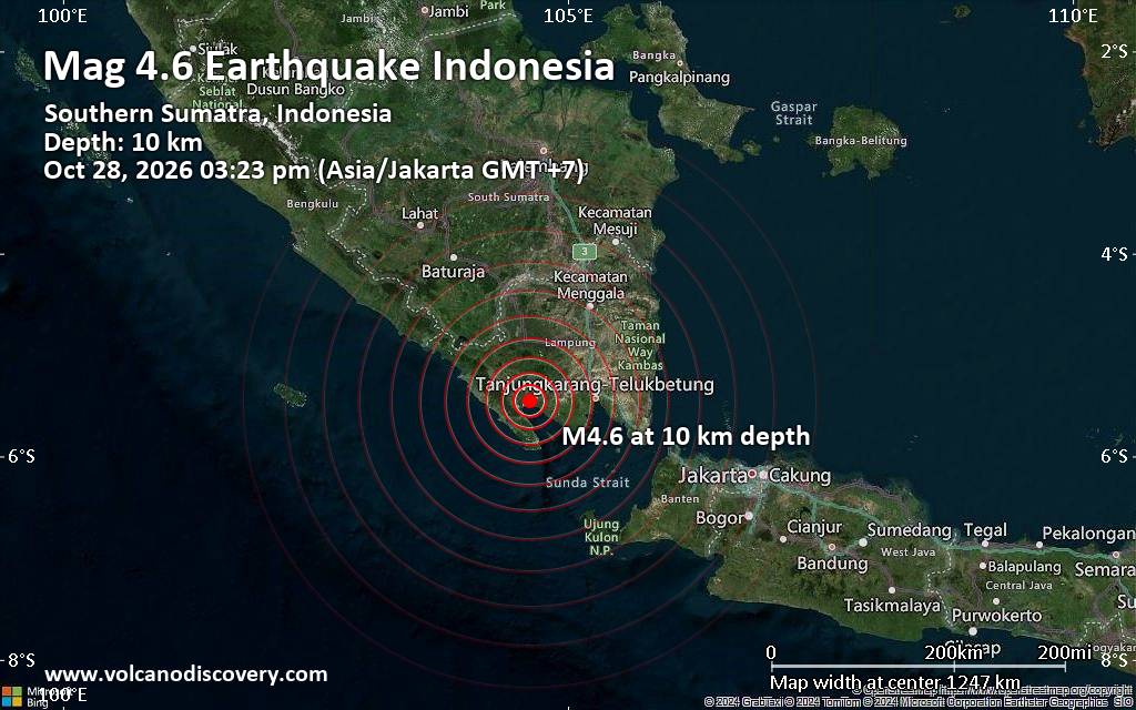
Moderate magnitude 4.6 earthquake 71 km west of Bandar Lampung, Indonesia
• M 1.3 - 19 km N of Borrego Springs, CA
• M 4.3 - 231 km S of Port Blair, India
• M 3.8 - 21 km SE of Esperanza, Puerto Rico
• M 2.0 - 0 km ENE of Honoka‘a, Hawaii
• M 2.4 - 26 km E of Honaunau-Napoopoo, Hawaii
• M 4.6 - 52 km N of Pante Makasar, Timor Leste
|
|
|
Joined: Feb 2001
Posts: 678,977
Launch Director
|
|
Launch Director
Joined: Feb 2001
Posts: 678,977 |
SPC Oct 28, 2026 0600 UTC Day 1 Convective OutlookSPC 1200Z Day 1 Outlook 
Day 1 Convective Outlook
NWS Storm Prediction Center Norman OK
1226 AM CDT Wed Oct 28 2026

Valid 281200Z - 291200Z

...THERE IS A SLIGHT RISK OF SEVERE THUNDERSTORMS ACROSS PORTIONS OF
EAST-CENTRAL MINNESOTA AND WEST-CENTRAL WISCONSIN....

...SUMMARY...
A few severe thunderstorms are possible over the Upper Mississippi
Valley on Wednesday with some tornado potential. Isolated large hail
and damaging winds will also be possible.

...Synopsis...
The overall mid-level pattern across the CONUS will become more
zonal through the day today. Within this more zonal pattern, a
mid-level shortwave trough will traverse the northern Plains. A weak
surface low, associated with this mid-level trough, will deepen as
it moves northeastward through the day. Elsewhere, high pressure
will dominate through the day and evening.

...Upper Mississippi Valley...
Low-level moisture will advect northward today as a surface low,
currently analyzed across southeast Colorado, deepens and moves
northeastward to the Upper Midwest. This will result in weak
instability into southern and central Minnesota with dewpoints in
the upper 50s. During peak heating, storms are expected to develop
near this surface low within the weakly unstable zone. Veered wind
profiles and strong deep-layer shear will support a discrete mode
including the potential for supercells. In fact, wind profiles are
quite favorable within this zone with instability being the primary
limiting factor. However, it would only take an increase of a few
degrees in the dewpoint and/or temperature for greater instability
and potentially a more impactful event. Therefore, while the
forecast remains conditional, the ceiling could involve strong
tornado potential. Therefore, added a Slight Risk, driven by tornado
probabilities, for a small portion of eastern Minnesota and western
Wisconsin in the vicinity of the surface low near peak heating where
a several hour window of severe weather potential may exist. Shear
and storm mode will support some hail potential, but the overall
weaker instability precludes higher probabilities. The greatest
damaging wind potential will likely be along the warm front ahead of
the surface low where the potential for upscale growth is the
greatest. However, even within this zone, the wind threat should
remain somewhat subdued given the weak instability along this zone.

..Bentley/Halbert-E.. 10/28/2026
Read morehttps://www.spc.noaa.gov/products/outlook/day1otlk_1200.html
|
|



CMS The Best Conveyancing solicitors conveyancing quotes throughout the UK
For any webhosting enquiries please email webmaster@aus-city.com
|
|
Entire Thread
|

 SPC Oct 28, 2026 0600 UTC Day 1 Convective Outlook |
Webmaster
|
6 hours ago
|
|
Forums60
Topics898,228
Posts933,025
Members2,960
| |
Most Online102,106
Jul 10th, 2026
|
|
|









































