|
1 members (Alisa),
2,031
guests, and
27
robots. |
|
Key:
Admin,
Global Mod,
Mod
|
|
S |
M |
T |
W |
T |
F |
S |
|
|
|
|
|
1
|
2
|
3
|
|
4
|
5
|
6
|
7
|
8
|
9
|
10
|
|
11
|
12
|
13
|
14
|
15
|
16
|
17
|
|
18
|
19
|
20
|
21
|
22
|
23
|
24
|
|
25
|
26
|
27
|
28
|
29
|
30
|
31
|
|
There are no members with birthdays on this day. |
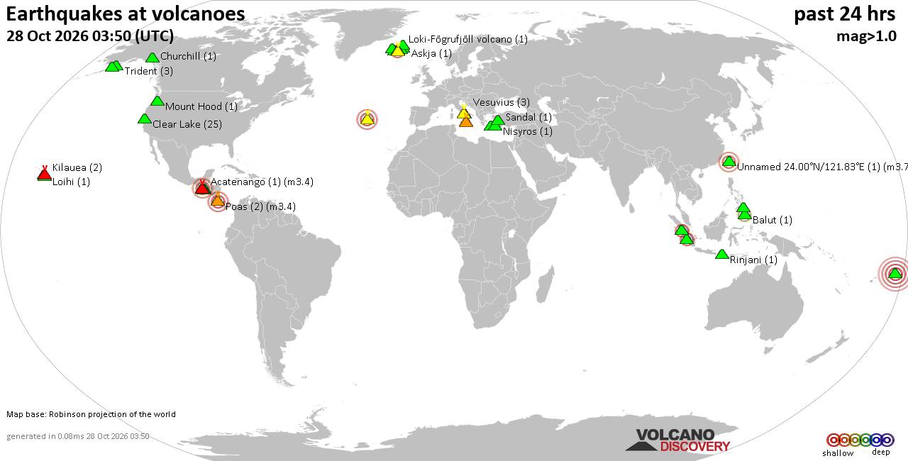
Volcano earthquake report for Wednesday, 28 October 2026
• M 1.5 - 41 km S of South Van Horn, Alaska
• M 4.0 - 10 km N of Lake Pillsbury, CA
• M 2.3 - 49 km W of Nanwalek, Alaska
• M 1.6 - 7 km ENE of Adak, Alaska
• M 1.3 - 59 km ESE of McCarthy, Alaska
|
|
|
Joined: Feb 2001
Posts: 678,977
Launch Director
|
|
Launch Director
Joined: Feb 2001
Posts: 678,977 |
SPC Oct 28, 2026 1630 UTC Day 1 Convective OutlookSPC 1630Z Day 1 Outlook 
Day 1 Convective Outlook
NWS Storm Prediction Center Norman OK
1120 AM CDT Wed Oct 28 2026

Valid 281630Z - 291200Z

...THERE IS A SLIGHT RISK OF SEVERE THUNDERSTORMS ACROSS PARTS OF
EASTERN MINNESOTA INTO NORTHWEST WISCONSIN...

...SUMMARY...
A few severe thunderstorms may occur over parts of Minnesota and
Wisconsin this afternoon and early evening. Isolated tornadoes,
severe hail, and damaging winds will be possible.

...Upper Midwest...
Within a zone of enhanced southwesterly mid-level flow across the
north-central CONUS, a shortwave trough over the northern High
Plains late this morning will advance east-northeastward towards the
Upper Midwest this afternoon/evening. A related surface low over the
central High Plains will likewise develop northeastward to
south-central MN by mid afternoon, with a trailing cold front
extending southwestward across the northern/central Plains. Latest
surface observations and observed 12Z soundings across the Upper
Midwest/central Plains show limited low-level moisture present in
the warm sector (surface dewpoints generally in the mid to upper
50s). This will tend to hinder the development of any more than weak
instability (MLCAPE generally 500-1000 J/kg, perhaps locally
stronger southward in IA ahead of the cold front), even as surface
temperatures continue to warm into the 60s with filtered diurnal
heating.

Strengthening low/mid-level winds through the afternoon will easily
support favorable veering wind profiles with height and around 30-40
kt of deep-layer shear. This shear, coupled with potentially
sufficient boundary-layer instability, may support a narrow zone of
severe potential with thunderstorms that develop near/just east of
the surface low across southern/eastern MN into northwest WI this
afternoon. Even with neutral lapse rates/saturated low-level
profiles depicted across this region per recent RAP forecast
soundings, the presence of elongated/curved low-level hodographs may
still support some risk for a couple of tornadoes with any
supercells that can become established and remain surface based.
Otherwise, isolated severe hail and damaging winds also appear
possible as convection spreads quickly northeastward through the
late afternoon/early evening before weakening with the loss of
daytime heating. Some of this activity may become slightly elevated,
but it could still pose some hail/gusty wind threat.

The potential for robust thunderstorm development farther south into
IA and eastern NE along/ahead of the cold front remains uncertain,
as large-scale ascent will be weaker with southward extent across
this area. If convection can initiate and persist, then occasional
hail could occur with the strongest cores. Have maintained the
Marginal Risk across this region for this rather conditional
possibility.

...Far West Texas/Southeast New Mexico...
A strong thunderstorm or two appears possible again this afternoon
along/east of the Guadalupe Mountains of southeast NM and the Davis
Mountains in far west TX. Forcing for ascent will remain weak, and
overall thunderstorm coverage should remain rather isolated.

..Gleason/Lyons.. 10/28/2026
Read morehttps://www.spc.noaa.gov/products/outlook/day1otlk_1630.html
|
|



CMS The Best Conveyancing solicitors conveyancing quotes throughout the UK
For any webhosting enquiries please email webmaster@aus-city.com
|
|
Entire Thread
|

 SPC Oct 28, 2026 1630 UTC Day 1 Convective Outlook |
Webmaster
|
7 hours ago
|
|
Forums60
Topics899,385
Posts934,182
Members2,960
| |
Most Online102,106
Jul 10th, 2026
|
|
|









































