|
|
|
1 members (Alisa),
1,830
guests, and
37
robots. |
|
Key:
Admin,
Global Mod,
Mod
|
|
S |
M |
T |
W |
T |
F |
S |
|
1
|
2
|
3
|
4
|
5
|
6
|
7
|
|
8
|
9
|
10
|
11
|
12
|
13
|
14
|
|
15
|
16
|
17
|
18
|
19
|
20
|
21
|
|
22
|
23
|
24
|
25
|
26
|
27
|
28
|
|
29
|
30
|
|
|
|
|
|
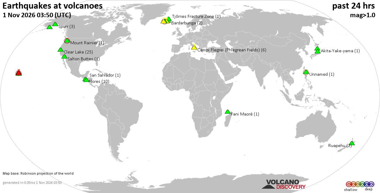
Volcano earthquake report for Sunday, 1 November 2026
• M 0.1 - 63 km ENE of Pedro Bay, Alaska
• M 0.8 - 45 km W of Ninilchik, Alaska
• M 0.7 - 79 km ENE of Port Alsworth, Alaska
• M 4.5 - 169 km SSW of Pagar Alam, Indonesia
• M 0.8 - 15 km WSW of Johannesburg, CA
• M 0.8 - 7 km NW of The Geysers, CA
|

#938282
Fri 30 Oct 2026 12:31:AM
|
Joined: Feb 2001
Posts: 678,977
Launch Director
|
|
Launch Director
Joined: Feb 2001
Posts: 678,977 |
SPC Oct 30, 2026 0100 UTC Day 1 Convective OutlookSPC 0100Z Day 1 Outlook 
Day 1 Convective Outlook
NWS Storm Prediction Center Norman OK
0728 PM CDT Thu Oct 29 2026

Valid 300100Z - 301200Z

...THERE IS A MARGINAL RISK OF SEVERE THUNDERSTORMS ACROSS PARTS OF
CENTRAL AND NORTHEAST KANSAS...AND LOCALLY IN SOUTHWEST TEXAS...

...SUMMARY...
Thunderstorms with an isolated hail threat will be possible this
evening over parts of central and northeast Kansas. A brief tornado
will be possible in parts of southwest Texas early this evening.

...Central and Northeast Kansas...
An anticyclonic flow pattern is evident over much of the central U.S
on water vapor imagery. At the surface, a stalled front is located
in central Kansas extending eastward into southern Illinois. Widely
scattered thunderstorms are developing near the front in central
Kansas in a moderately unstable airmass according the RAP, with
MLCAPE estimated to be around 2000 J/kg. Near the pocket of stronger
instability, the RAP has 700-500 mb lapse rates in the 6.5 to 7 C/km
range along with enough deep-layer shear for cell rotation. This
could be sufficient for a hail threat with the strongest of cells
this evening, as storms move and develop northeastward from central
Kansas into northeast Kansas...see MCD 2419.

...Southwest Texas...
A subtle shortwave trough is evident on water vapor imagery over
northern Mexico. Ahead of this feature, pockets of large-scale
ascent are evident over parts of Texas, where widespread
precipitation is ongoing. Weak instability is analyzed by the RAP
over parts of southwest, west and northwest Texas. The strongest
low-level flow is located over the western Texas Hill Country, where
RAP forecast soundings early this evening have 0-3 km storm-relative
helicity around 225 m2/s2 and surface dewpoints near 70 F. This
could be enough for a brief tornado with low-topped cells that
rotate within the moist airmass over the next couple more
hours...see MCD 2418.

..Broyles.. 10/30/2026
Read morehttps://www.spc.noaa.gov/products/outlook/day1otlk_0100.html
|
|



CMS The Best Conveyancing solicitors conveyancing quotes throughout the UK
For any webhosting enquiries please email webmaster@aus-city.com
|
|
Entire Thread
|
 SPC Oct 30, 2026 0100 UTC Day 1 Convective Outlook |
Webmaster
|
Fri 30 Oct 2026 12:31:AM
|
|
Forums60
Topics904,720
Posts939,517
Members2,960
| |
Most Online102,106
Jul 10th, 2026
|
|
|
|
|

|









































