|
|
|
0 members (),
3,050
guests, and
19
robots. |
|
Key:
Admin,
Global Mod,
Mod
|
|
S |
M |
T |
W |
T |
F |
S |
|
1
|
2
|
3
|
4
|
5
|
6
|
7
|
|
8
|
9
|
10
|
11
|
12
|
13
|
14
|
|
15
|
16
|
17
|
18
|
19
|
20
|
21
|
|
22
|
23
|
24
|
25
|
26
|
27
|
28
|
|
29
|
30
|
|
|
|
|
|
|
There are no members with birthdays on this day. |
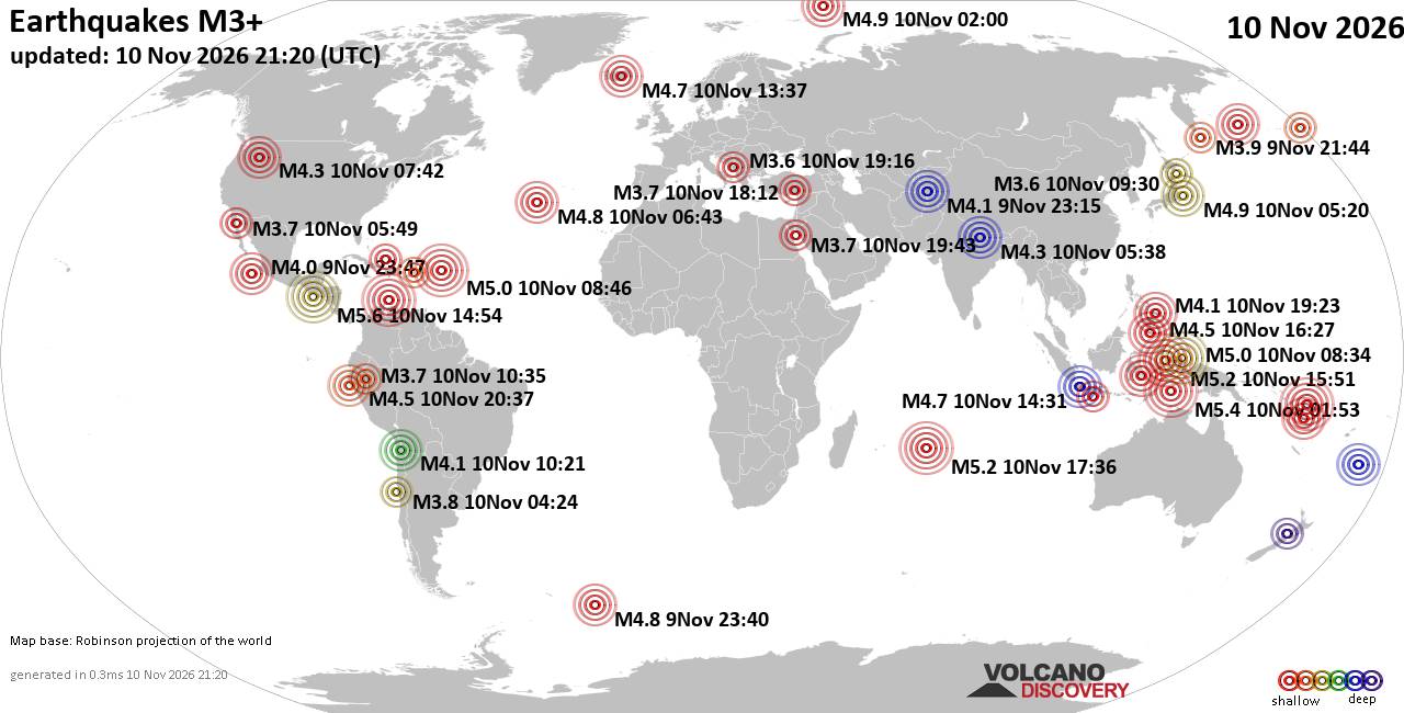
World Earthquake Report for Tuesday, 10 November 2026
• M -0.3 - 76 km NE of Nikolski, Alaska
• M 1.1 - 9 km S of Lake Henshaw, CA
• M 1.7 - 0 km SW of Pāhala, Hawaii
• M 1.2 - 26 km WSW of Westley, CA
• M 1.2 - 10 km W of Forsan, Texas
|
|
|
Joined: Feb 2001
Posts: 800,656
Launch Director
|
|
Launch Director
Joined: Feb 2001
Posts: 800,656 |
SPC Nov 10, 2026 2000 UTC Day 1 Convective OutlookSPC 2000Z Day 1 Outlook 
Day 1 Convective Outlook
NWS Storm Prediction Center Norman OK
0143 PM CST Tue Nov 10 2026

Valid 102000Z - 111200Z

...THERE IS A MARGINAL RISK OF SEVERE THUNDERSTORMS ACROSS THE
MIDDLE TO UPPER TEXAS COAST...

...SUMMARY...
Thunderstorms capable of isolated hail are possible along the Middle
to Upper Texas Coast tonight.

...20Z Update...
The forecast remains on track, and no changes were needed with this
update. See the previous discussion below for details.

..Weinman.. 11/10/2026

.PREV DISCUSSION... /ISSUED 1019 AM CST Tue Nov 10 2026/

...TX Coast...
Recent surface analysis places an inverted trough just off the Lower
TX Coast. Warm-air advection near this trough is supporting an area
of showers and thunderstorms. 12Z BRO and CRP soundings show a deep
and moist boundary layer atop relatively cool mid-level temperatures
(around -9 to -10 deg C at 500 mb). Enhanced mid-level flow exists
above 700 mb as well, contributing to moderate shear within the
cloud bearing layer. These factors could support isolated updrafts
capable of marginally severe hail through the early afternoon.
Weakening warm-air advection should lead to weakening thunderstorm
coverage and intensity during the late afternoon/early evening.

The weak vorticity maximum currently over the TX South Plains will
drift southeastward today, interacting with this more moist and
buoyant airmass along the coast around 00Z. Ascent associated with
this wave coupled with modest warm-air advection will likely result
in increasing thunderstorm coverage after 00Z. Mid-level
temperatures will cool slightly as well, supporting an increase in
the elevated buoyancy across the region. Mid-level flow throughout
this layer will remain strong, with cloud-bearing layer shear over
50 kt. These environmental conditions appear supportive of
marginally severe hail within any of the more persistent updrafts.

...Elsewhere...
Occasional lightning flashes may occur with low-topped convection
that will move quickly east-northeastward across parts of coastal WA
today in tandem with another mid-level shortwave trough, but very
weak instability will limit the severe threat with this activity.
Late afternoon thunderstorms are also possible within the moist
confluent flow over the central/southern FL Peninsula.

A few flashes are also possible near the center of the TX vorticity
maximum over central/north-central TX this afternoon/early evening.
Thunderstorm coverage in this region is currently expected to be
less than 10 percent.
Read morehttps://www.spc.noaa.gov/products/outlook/day1otlk_2000.html
|
|



CMS The Best Conveyancing solicitors conveyancing quotes throughout the UK
For any webhosting enquiries please email webmaster@aus-city.com
|
|
Entire Thread
|

 SPC Nov 10, 2026 2000 UTC Day 1 Convective Outlook |
Webmaster
|
2 hours ago
|
|
Forums60
Topics921,030
Posts955,827
Members2,960
| |
Most Online102,106
Jul 10th, 2026
|
|
|
|
|

|









































