|
|
|
1 members (Alisa),
2,400
guests, and
23
robots. |
|
Key:
Admin,
Global Mod,
Mod
|
|
S |
M |
T |
W |
T |
F |
S |
|
1
|
2
|
3
|
4
|
5
|
6
|
7
|
|
8
|
9
|
10
|
11
|
12
|
13
|
14
|
|
15
|
16
|
17
|
18
|
19
|
20
|
21
|
|
22
|
23
|
24
|
25
|
26
|
27
|
28
|
|
29
|
30
|
|
|
|
|
|
|
There are no members with birthdays on this day. |
Volcano earthquake report for Thursday, 12 November 2026
• M 1.8 - 15 km E of Pearsall, Texas
• M 1.8 - 15 km E of Pearsall, Texas
• M 1.5 - 5 km WNW of San Francisco Zoo, CA
• M 1.5 - 5 km WNW of San Francisco Zoo, CA
• M 2.1 - 63 km SE of Denali National Park, Alaska
• M 2.1 - 63 km SE of Denali National Park, Alaska
|
|
|
Joined: Feb 2001
Posts: 800,656
Launch Director
|
|
Launch Director
Joined: Feb 2001
Posts: 800,656 |
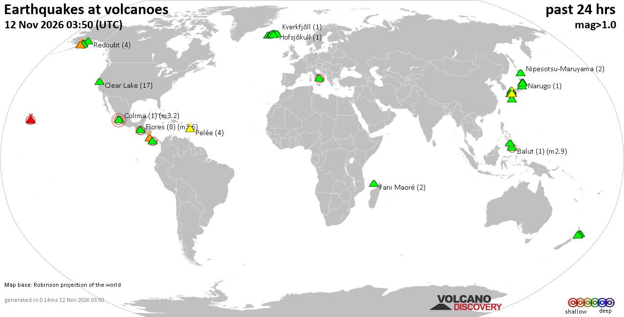
Volcano earthquake report for Thursday, 12 November 2026World map showing volcanoes with shallow (less than 50 km) earthquakes within 20 km radius during the past 24 hours on 12 Nov 2026 Number in brackets indicate nr of quakes. Quakes detected near: Abu (9 quakes between mag 0.3-1.4), Alaska Peninsula Arc at 155.4°W (1 quake mag 1.4), Aragats (1 quake mag 2.0), Askja (2 quakes between mag 0.9-1.3), Aso (1 quake mag 1.4), Balut (2 quakes between mag 1.7-3.2)
Bardarbunga (2 quakes between mag 0.8-3.3), Cagua (2 quakes between mag 1.7-2.2), Campi Flegrei (Phlegrean Fields) (3 quakes between mag 0.1-1.4), Chiquimula Volcanic Field (1 quake mag 3.2), Churchill (1 quake mag 1.4), Clear Lake (26 quakes between mag 0.3-1.7), El Hierro (1 quake mag 2.4), Fani Maoré (2 quakes between mag 1.4-4.3), Flores (1 quake mag 2.5), Grímsnes (3 quakes between mag 0.2-2.2), Hofsjökull (1 quake mag 1.4), Iliamna (13 quakes between mag 0.2-1.1), Kalatungan (1 quake mag 1.9), Katla (4 quakes between mag 0.5-1.4), Loihi (1 quake mag 2.4), Nevado del Ruiz (2 quakes between mag 0.7-1.1), Nipesotsu-Maruyama (4 quakes between mag 0.2-1.0), Numazawa (7 quakes between mag 0.2-1.1), Ontake-san (7 quakes between mag 0.1-1.3), Pelée (13 quakes between mag 0.0-1.2), Piton de la Fournaise (1 quake mag 1.0), Prestahnukur (2 quakes between mag 1.3-1.3), Ragang (1 quake mag 3.2), Ruapehu (2 quakes between mag 1.1-1.2), Salton Buttes (1 quake mag 1.4), Sandal (1 quake mag 1.5), Suwanosejima (2 quakes between mag 1.4-2.6), Svartsengi (3 quakes between mag 0.6-1.3), Talakmau (1 quake mag 2.5), Tecuamburro (1 quake mag 1.9), Tsurumi (13 quakes between mag 0.2-2.0), Unzen (7 quakes between mag 0.1-1.2), Veniaminof (1 quake mag 1.9), Vesuvius (3 quakes between mag 0.1-2.6) (updated 22h50)\n\nNote: Earthquakes within 20 km from and at depths less than 50 km under active volcanoes are reported. The list is not complete because many volcanoes are not monitored and/or seismic data in high resolution is not available publicly.\n
Volcanoes with recent earthquakes above magnitude 2 or more than 10 quakes are listed below:
Balut volcano (Mindanao): 2 earthquakes up to magnitude 3.22 earthquakes occurred near (under) the volcano at nearly the same time (12:56 UTC). Hypocenter depths ranged between 31.00 and 26.00 km. Earthquake details: 3.2 quake Celebes Sea, 22 km west of Sarangani Island, Philippines, Nov 12, 2026 08:56 pm (Manila time) (11 km WNW) 1.7 quake Celebes Sea, 26 km west of Sarangani Island, Philippines, Nov 12, 2026 08:56 pm (Manila time) (14 km W) All earthquakes at BalutBalut is an 840 m island stratovolcano south of Mindanao whose last known eruption occurred between about 2 million and 11,700 years ago. Hot springs and thermally altered ground occur on its western and southwestern flanks. Bardarbunga volcano (Iceland): 2 earthquakes up to magnitude 3.32 earthquakes occurred near (under) the volcano during 6 hours, the last being recorded quake 56 minutes ago. Hypocenter depths ranged between 7.80 and 5.30 km. Earthquake details: 3.3 quake 118 km south of Akureyri, Northeast, Iceland, Nov 12, 2026 09:53 pm (Reykjavik time) (4 km NE) 0.8 quake 5.3 km E of Bárðarbunga Nov 12, 2026 03:48 pm (Reykjavik time) (6 km ENE) All earthquakes at BardarbungaBárðarbunga is an ice-covered Icelandic stratovolcano whose far-reaching fissure system has produced enormous lava flows and major explosive eruptions. Its 2014-15 Holuhraun eruption created a lava field of almost 85 km². Cagua volcano (Luzon Island): 2 earthquakes up to magnitude 2.22 earthquakes occurred near (under) the volcano during 1 hour 17 minutes, the last being recorded quake 4 hours ago. Hypocenter depths ranged between 12.00 and 11.00 km. Earthquake details: 2.2 quake 48 km east of Aparri, Province of Cagayan, Cagayan Valley, Philippines, Nov 13, 2026 02:53 am (Manila time) (6 km NW) 1.7 quake 47 km east of Aparri, Province of Cagayan, Cagayan Valley, Philippines, Nov 13, 2026 01:36 am (Manila time) (7 km NW) All earthquakes at CaguaCagua is a forested stratovolcano at the northeastern tip of Luzon, locally called the “Mountain of Fire.” Its last known eruption was a phreatic explosion in 1860 that produced ash and possibly a pyroclastic flow. Chiquimula Volcanic Field volcano (Guatemala): magnitude 3.2 earthquakeA magnitude 3.2 earthquake occurred at the volcano 8 hours ago. The quake, which might be volcanic in origin, was located at a depth of 2.00 km depth at 17 km distance N from the volcano. Earthquake details: 3.2 quake 4.1 km northwest of Zacapa, Departamento de Zacapa, Guatemala, Nov 12, 2026 08:53 am (GMT -6) (17 km N) All earthquakes at Chiquimula Volcanic FieldThis volcanic field in southeastern Guatemala contains lava flows and numerous cones, some beside Chiquimula town. No historical eruptions are known, although the unmeasured age of youthful-looking lava at Cerro Chiquito remains uncertain. Clear Lake volcano (California): 26 earthquakes up to magnitude 1.7Possible earthquake swarm: 26 earthquakes occurred near (under) the volcano during 23 hours, the last being recorded quake 15 minutes ago. Hypocenter depths ranged between 4.08 and 0.46 km. Earthquake details: (only 5 largest) 1.7 quake Sonoma County, 14 mi southwest of Clearlake, Lake County, California, United States, Nov 12, 2026 05:48 am (GMT -8) (16 km SSW) 1.6 quake 12 mi southwest of Clearlake, Lake County, California, United States, Nov 12, 2026 06:16 am (GMT -8) (16 km S) 1.5 quake Sonoma County, 13 mi southwest of Clearlake, Lake County, California, United States, Nov 12, 2026 11:08 am (GMT -8) (16 km SSW) 1.3 quake Lake County, 25 mi north of Santa Rosa, Sonoma County, California, United States, Nov 12, 2026 08:21 am (GMT -8) (19 km S) 1.2 quake 26 mi north of Santa Rosa, Sonoma County, California, United States, Nov 12, 2026 02:35 pm (GMT -8) (18 km S) All earthquakes at Clear LakeEl Hierro volcano (Canary Islands): magnitude 2.4 earthquakeA magnitude 2.4 earthquake occurred at the volcano 8 hours ago. The quake, which might be volcanic in origin, was located at a depth of 11.80 km depth at 6 km distance W from the volcano. Earthquake details: 2.4 quake 16 km south of Frontera, Santa Cruz de Tenerife, Canary Islands, Spain, Nov 12, 2026 02:59 pm (Universal Time) (6 km W) All earthquakes at El HierroEl Hierro is a shield volcano in Spain’s Canary Islands. Its first documented historical eruption occurred underwater south of the island in 2011–12 and built a new volcanic cone on the seabed. Fani Maoré volcano (Indian Ocean): 2 earthquakes up to magnitude 4.32 earthquakes occurred near (under) the volcano during 8 hours, the last being recorded quake 15 hours ago. Hypocenter depths ranged between 41.74 and 29.90 km. Earthquake details: 4.3 quake 45 km east of Mamoudzou, Mamoudzou, Mayotte, Nov 12, 2026 11:13 am (GMT +3) (13 km NNW) 1.4 quake 47 km east of Mamoudzou, Mamoudzou, Mayotte, Nov 12, 2026 02:48 am (GMT +3) (8 km W) All earthquakes at Fani MaoréFani Maoré is a submarine volcano about 50 km east of Mayotte. Seismic unrest began in May 2018, and surveys in 2019 discovered a new 800-m-high cone and extensive lava flows on the seafloor. Flores volcano (Guatemala): magnitude 2.5 earthquakeA magnitude 2.5 earthquake occurred at the volcano 20 hours ago. The quake, which might be volcanic in origin, was located at a depth of 5.00 km depth at 15 km distance NW from the volcano. Earthquake details: 2.5 quake 25 km northeast of Cuilapa, Departamento de Santa Rosa, Guatemala, Nov 11, 2026 08:48 pm (GMT -6) (15 km NW) All earthquakes at FloresFlores, also known as Volcán Amayo, is a volcanic field about 10 km west of Jutiapa in southeastern Guatemala. Its last eruption is undated, and none are known from approximately the past 11,700 years. Grímsnes volcano (Iceland): 3 earthquakes up to magnitude 2.23 earthquakes occurred near (under) the volcano during 4 hours, the last being recorded quake 56 minutes ago. Hypocenter depths ranged between 4.70 and 0.00 km. Earthquake details: 2.2 quake 13.8 km E of Hrómundartindi Nov 12, 2026 09:54 pm (Reykjavik time) (8 km NNW) 0.6 quake Iceland: 8.1 km WSW of Selfoss Nov 12, 2026 06:15 pm (Reykjavik time) (19 km SW) 0.2 quake Iceland: 2.8 km WSW of Þjórsárbrú Nov 12, 2026 07:39 pm (Reykjavik time) (15 km SSE) All earthquakes at GrímsnesGrímsnes is an Icelandic volcanic field whose 11 fissures produced crater rows and extensive basaltic lava flows. Its 11 known eruptive periods occurred between approximately 7750 and 3500 BCE, with no eruptions known from historical times. Iliamna volcano (Cook Inlet (SW Alaska)): 13 earthquakes up to magnitude 1.1Possible earthquake swarm: 13 earthquakes occurred near (under) the volcano during 18 hours, the last being recorded quake 17 minutes ago. Hypocenter depths ranged between 36.40 and 5.00 km. Earthquake details: (only 5 largest) 1.1 quake Kenai Peninsula Borough, 135 mi southwest of Anchorage, Anchorage Municipality, Alaska, United States, Nov 12, 2026 01:32 pm (GMT -9) (4 km N) 0.7 quake Kenai Peninsula Borough, 135 mi southwest of Anchorage, Anchorage Municipality, Alaska, United States, Nov 12, 2026 07:01 am (GMT -9) (2 km NE) 0.6 quake Kenai Peninsula Borough, 128 mi southwest of Anchorage, Anchorage Municipality, Alaska, United States, Nov 12, 2026 06:27 am (GMT -9) (14 km NNE) 0.6 quake Kenai Peninsula Borough, 139 mi southwest of Anchorage, Anchorage Municipality, Alaska, United States, Nov 12, 2026 05:01 am (GMT -9) (19 km NW) 0.6 quake Kenai Peninsula Borough, 136 mi southwest of Anchorage, Anchorage Municipality, Alaska, United States, Nov 11, 2026 09:42 pm (GMT -9) (6 km NW) All earthquakes at IliamnaIliamna is a glacier-covered Alaskan stratovolcano whose conspicuous fumarolic steam plumes have sometimes been mistaken for eruptions. Its last confirmed eruption occurred in 1876, although uncertain reports continued into the 1950s. Loihi volcano (Hawai'i (Big Island)): magnitude 2.4 earthquakeA magnitude 2.4 earthquake occurred at the volcano 10 hours ago. The quake, which might be volcanic in origin, was located at a depth of 16.77 km depth at 9 km distance SSW from the volcano. Earthquake details: 2.4 quake North Pacific Ocean, 25 mi southeast of Discovery Harbor, Hawaii County, Hawaii, United States, Nov 12, 2026 02:50 am (GMT -10) (9 km SSW) All earthquakes at LoihiLoihi, now named Kamaʻehuakanaloa, is a submarine shield volcano about 35 km southeast of Hawaiʻi. Its last confirmed eruption was in 1996, while later unrest has consisted of earthquake swarms without confirmed eruptions. Pelée volcano (Caribbean): 13 earthquakes up to magnitude 1.2Possible earthquake swarm: 13 earthquakes occurred near (under) the volcano during 20 hours, the last being recorded quake 4 hours ago. Hypocenter depths ranged between 0.49 and 0.25 km. Earthquake details: (only 5 largest) 1.2 quake 25 km northwest of Fort-de-France, Martinique, Nov 12, 2026 02:59 pm (GMT -4) (0 km SW) 1.0 quake 25 km northwest of Fort-de-France, Martinique, Nov 12, 2026 02:59 pm (GMT -4) (0 km WSW) 0.9 quake 25 km northwest of Fort-de-France, Martinique, Nov 12, 2026 02:59 pm (GMT -4) (0 km SSW) 0.9 quake 25 km northwest of Fort-de-France, Martinique, Nov 12, 2026 07:04 am (GMT -4) (0 km ENE) 0.8 quake 25 km northwest of Fort-de-France, Martinique, Nov 12, 2026 07:19 am (GMT -4) (0 km S) All earthquakes at PeléePelée is the Martinique stratovolcano whose catastrophic 1902 eruption destroyed Saint-Pierre and became the defining example of Peléan eruptions. Its last known eruption ended in 1932. Ragang volcano (Mindanao): magnitude 3.2 earthquakeA magnitude 3.2 earthquake occurred at the volcano 15 hours ago. The quake, which might be volcanic in origin, was located at a depth of 6.00 km depth at 6 km distance WNW from the volcano. Earthquake details: 3.2 quake 37 km southeast of Marawi City, Philippines, Nov 12, 2026 03:25 pm (Manila time) (6 km WNW) All earthquakes at RagangRagang is a 2,790 m stratovolcano in central Mindanao with eight confirmed eruptive periods since the mid-18th century. Its last known eruption occurred in 1916 and included a lava flow. Suwanosejima volcano (Ryukyu Islands): 2 earthquakes up to magnitude 2.62 earthquakes occurred near (under) the volcano during 18 minutes, the last being recorded quake 18 hours ago. Hypocenter depths ranged between 2.70 and 0.00 km. Earthquake details: 2.6 quake East China Sea, Kagoshima-ken, 13 km northeast of Suwanose-jima Island, Japan, Nov 12, 2026 01:46 pm (GMT +9) (13 km ENE) 1.4 quake East China Sea, Kagoshima-ken, 12 km northeast of Suwanose-jima Island, Japan, Nov 12, 2026 01:28 pm (GMT +9) (12 km NE) All earthquakes at SuwanosejimaSuwanosejima is one of Japan’s most frequently active volcanoes, with recurring explosions, ash plumes and incandescent ejecta. Its largest recorded eruption occurred in 1813-14, and an eruption that began in October 2004 continued into 2026. Talakmau volcano (Sumatra): magnitude 2.5 earthquakeA magnitude 2.5 earthquake occurred at the volcano 48 minutes ago. The quake, which might be volcanic in origin, was located at a depth of 16.00 km depth at 7 km distance ESE from the volcano. Earthquake details: 2.5 quake Kabupaten Pasaman, 55 km northwest of Bukittinggi, Indonesia, Nov 13, 2026 05:01 am (GMT +7) (7 km ESE) All earthquakes at TalakmauTalakmau is a 2,911 m volcanic complex in western Sumatra with three aligned summit craters and a lava dome. Reports of historical eruptions, including an event in 1937, remain uncertain. Tsurumi volcano (Kyushu): 13 earthquakes up to magnitude 2.0Possible earthquake swarm: 13 earthquakes occurred near (under) the volcano during 5 hours, the last being recorded quake 5 hours ago. Hypocenter depths ranged between 9.90 and 5.80 km. Earthquake details: (only 5 largest) 2.0 quake 4.5 km west of Beppu, Oita Prefecture, Japan, Nov 12, 2026 09:34 pm (GMT +9) (2 km E) 1.1 quake 10.2 km west of Beppu, Oita Prefecture, Japan, Nov 13, 2026 02:04 am (GMT +9) (4 km WSW) 0.9 quake 20 km west of Oita, Oita Prefecture, Japan, Nov 13, 2026 01:36 am (GMT +9) (4 km WSW) 0.8 quake 20 km west of Oita, Oita Prefecture, Japan, Nov 13, 2026 02:10 am (GMT +9) (4 km WSW) 0.7 quake 21 km west of Oita, Oita Prefecture, Japan, Nov 13, 2026 01:12 am (GMT +9) (5 km WSW) All earthquakes at TsurumiTsurumi is part of the Yufu-Tsurumi lava-dome complex above Beppu on Kyushu. Its three known eruptive periods culminated in explosive summit activity in 867 CE. Vesuvius volcano (Italy): 3 earthquakes up to magnitude 2.63 earthquakes occurred near (under) the volcano during 26 minutes, the last being recorded quake 19 hours ago. Hypocenter depths ranged between 1.40 and 0.90 km. Earthquake details: 2.6 quake 6.2 km northeast of Torre del Greco, Napoli, Campania, Italy, Nov 12, 2026 04:11 am (GMT +1) (0 km NNE) 0.3 quake 15 km east of Naples, Napoli, Campania, Italy, Nov 12, 2026 04:37 am (GMT +1) (1 km E) 0.1 quake 1.4 km north of Ottaviano, Napoli, Campania, Italy, Nov 12, 2026 04:11 am (GMT +1) (7 km NE) All earthquakes at Vesuviushttps://www.volcanodiscovery.com/earthquakes-volcanoes/news/407960/Volcano-earthquake-report-2026-11-12.html
|
|



CMS The Best Conveyancing solicitors conveyancing quotes throughout the UK
For any webhosting enquiries please email webmaster@aus-city.com
|
|
Entire Thread
|

 Volcano earthquake report for Thursday, 12 November 2026 |
Webmaster
|
Yesterday at 10:50 PM
|
|
Forums60
Topics924,817
Posts959,614
Members2,960
| |
Most Online102,106
Jul 10th, 2026
|
|
|
|
|

|









































