|
0 members (),
1,509
guests, and
24
robots. |
|
Key:
Admin,
Global Mod,
Mod
|
|
S |
M |
T |
W |
T |
F |
S |
|
1
|
2
|
3
|
4
|
5
|
6
|
7
|
|
8
|
9
|
10
|
11
|
12
|
13
|
14
|
|
15
|
16
|
17
|
18
|
19
|
20
|
21
|
|
22
|
23
|
24
|
25
|
26
|
27
|
28
|
|
29
|
30
|
|
|
|
|
|
|
There are no members with birthdays on this day. |
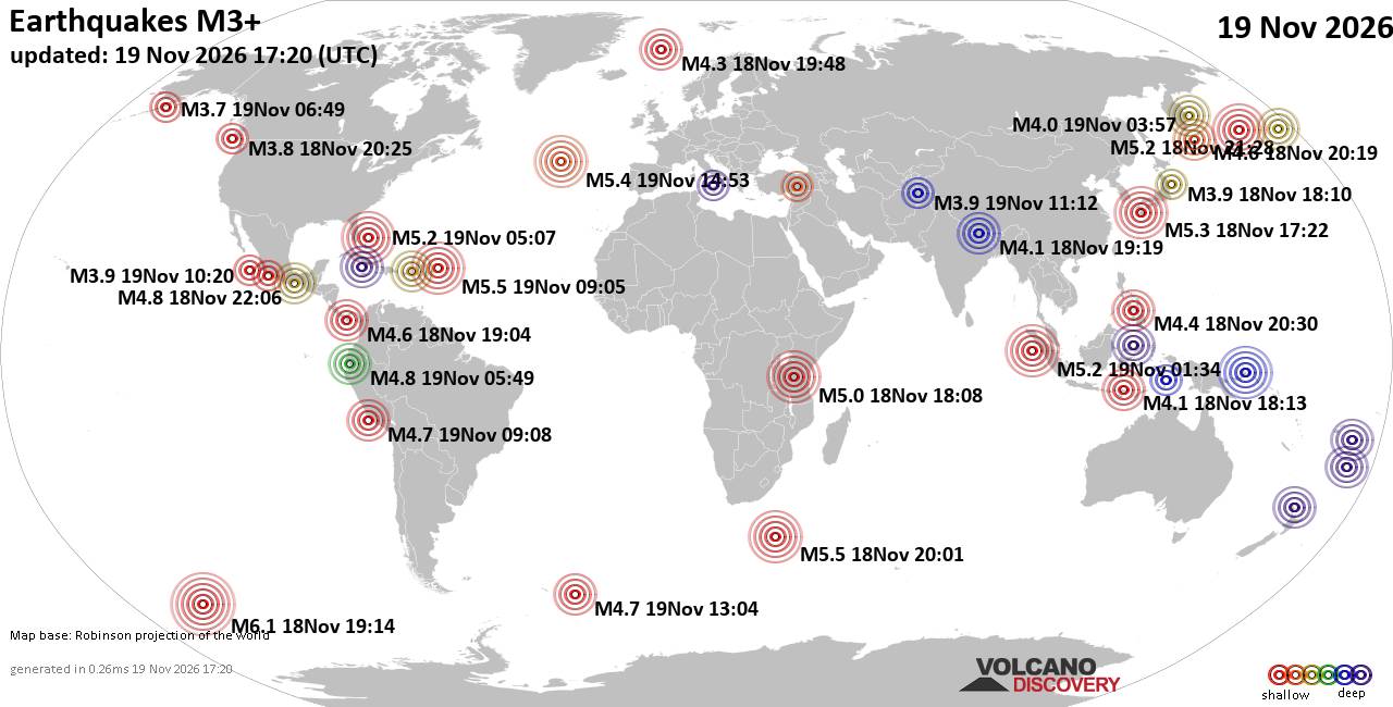
World Earthquake Report for Thursday, 19 November 2026
• M 1.8 - 23 km WSW of Ackerly, Texas
• M 0.7 - 2 km N of The Geysers, CA
• M 1.9 - 23 km E of Beluga, Alaska
• M 1.3 - 1 km E of The Geysers, CA
• M 1.2 - 14 km NNE of Milford, Utah
• M 4.4 - off the coast of Oregon
|
|
|
Joined: Feb 2001
Posts: 800,656
Launch Director
|
|
Launch Director
Joined: Feb 2001
Posts: 800,656 |
SPC Nov 19, 2026 2000 UTC Day 1 Convective OutlookSPC 2000Z Day 1 Outlook 
Day 1 Convective Outlook
NWS Storm Prediction Center Norman OK
0144 PM CST Thu Nov 19 2026

Valid 192000Z - 201200Z

...THERE IS A MARGINAL RISK OF SEVERE THUNDERSTORMS ACROSS PARTS OF
CENTRAL CALIFORNIA...

...SUMMARY...
Isolated thunderstorms capable of producing occasional severe gusts,
hail, and perhaps a brief tornado are possible today across parts of
central California, focused mainly over portions of the San Joaquin
Valley.

...20z Update...
The previous forecast largely remains on track. Latest surface
observations and satellite imagery show the best convective
environment emerging through the CA Central Valley where winds
remain out of the south/southeast and cloud breaks have yielded a
pocket of relatively greater surface heating (temperatures in the
low 60s). Recent mesoanalysis estimates suggest MLCAPE has increased
to around 500 J/kg, which should be sufficient for a few deeper,
stronger cores capable of producing hail, gusty winds, and perhaps a
brief tornado through early evening prior to the arrival of an
approaching cold front. Latest radar trends show a general uptick in
convective intensity within this regime, which aligns with
expectations and warranted the introduction of a small 5% hail risk
area (see MCD #2458 for additional short-term details in the
near-term severe threat). Risk probabilities were trimmed southward
to account for the passage of the cold front.

..Moore.. 11/19/2026

.PREV DISCUSSION... /ISSUED 1026 AM CST Thu Nov 19 2026/

...Central/Southern California...
A band of low-topped showers moving into the LA Basin this morning
is being aided by large-scale ascent associated with a highly
amplified upper trough over the West Coast, and strong mid-level jet
extending over much of central/southern CA into the Great Basin. The
latest VWP from KSOX shows veering/strengthening winds with height
through mid levels and sufficient shear for updraft organization.
However, minimal MUCAPE noted on the 12Z VBG sounding and recent RAP
forecast soundings across coastal southern CA should tend to limit
the threat for severe gusts associated with convection. That said,
strong/gusty gradient/non-convective winds will remain possible
today, as enhanced mid-level west-southwesterly flow attendant to
the upper trough persists over southern CA.

Cold temperatures aloft (around -24 to -28 C at 500 mb) will
overspread central CA through the afternoon as the upper trough and
mid-level jet move slowly inland in tandem with a surface front.
Although widespread cloudiness remains prevalent across the Central
Valley this morning per recent visible satellite imagery, there is
some potential for weak destabilization as filtered daytime heating
occurs. Greater low-level shear will be present this morning, with a
tendency for flow to gradually veer to westerly with time through
the afternoon. Still, any isolated thunderstorms that can develop
along/ahead of the front could pose a threat for small hail and
strong to locally severe gusts, mainly focused across parts of the
San Joaquin Valley. The tornado potential appears highly conditional
on a low-topped supercell developing and persisting even as
low-level shear slowly weakens through the day.
Read morehttps://www.spc.noaa.gov/products/outlook/day1otlk_2000.html
|
|



CMS The Best Conveyancing solicitors conveyancing quotes throughout the UK
For any webhosting enquiries please email webmaster@aus-city.com
|
|
Entire Thread
|

 SPC Nov 19, 2026 2000 UTC Day 1 Convective Outlook |
Webmaster
|
1 hour ago
|
|
Forums60
Topics935,961
Posts970,758
Members2,960
| |
Most Online102,106
Jul 10th, 2026
|
|
|









































