|
|
|
0 members (),
1,649
guests, and
21
robots. |
|
Key:
Admin,
Global Mod,
Mod
|
|
S |
M |
T |
W |
T |
F |
S |
|
1
|
2
|
3
|
4
|
5
|
6
|
7
|
|
8
|
9
|
10
|
11
|
12
|
13
|
14
|
|
15
|
16
|
17
|
18
|
19
|
20
|
21
|
|
22
|
23
|
24
|
25
|
26
|
27
|
28
|
|
29
|
30
|
|
|
|
|
|
|
There are no members with birthdays on this day. |
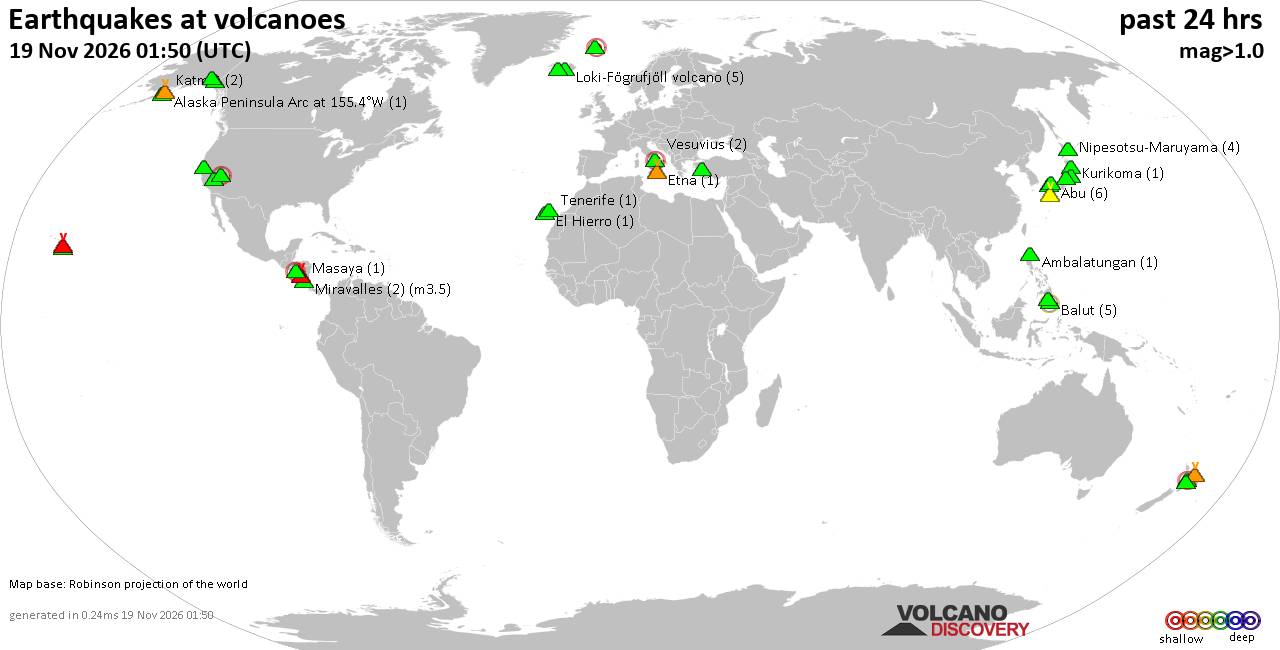
Volcano earthquake report for Thursday, 19 November 2026
• M 1.8 - 23 km WSW of Ackerly, Texas
• M 0.7 - 2 km N of The Geysers, CA
• M 1.9 - 23 km E of Beluga, Alaska
• M 1.3 - 1 km E of The Geysers, CA
• M 1.2 - 14 km NNE of Milford, Utah
|
|
|
Joined: Feb 2001
Posts: 800,656
Launch Director
|
|
Launch Director
Joined: Feb 2001
Posts: 800,656 |
Volcano earthquake report for Thursday, 19 November 2026World map showing volcanoes with shallow (less than 50 km) earthquakes within 20 km radius during the past 24 hours on 19 Nov 2026 Number in brackets indicate nr of quakes. Quakes detected near: Alaska Peninsula Arc at 155.4°W (1 quake mag 1.4), Aniakchak (1 quake mag 1.2), Askja (5 quakes between mag 0.0-1.1), Aso (1 quake mag 1.7), Balut (3 quakes between mag 2.5-3.2), Brennisteinsfjöll (4 quakes between mag 0.0-1.7)
Clear Lake (18 quakes between mag 0.3-1.6), Conchagüita (1 quake mag 2.3), Coso (2 quakes between mag 1.0-1.5), Eldey (3 quakes between mag 0.0-1.0), Eyafjallajökull (1 quake mag 1.2), Fourpeaked (1 quake mag 2.4), Golden Trout Creek (1 quake mag 2.0), Hofsjökull (1 quake mag 1.0), Jailolo (1 quake mag 2.3), Jumelles-Mwezi Volcanic Field (1 quake mag 2.1), Katla (3 quakes between mag 0.0-1.1), Katmai (1 quake mag 1.6), Kilauea (2 quakes between mag 1.7-2.1), Kukak (1 quake mag 1.7), Loihi (1 quake mag 1.9), Martin (2 quakes between mag 0.7-1.9), Maunaloa (1 quake mag 1.7), Methana (1 quake mag 2.0), Nevado del Huila (3 quakes between mag 1.5-1.8), Ngauruhoe (4 quakes between mag 0.5-1.4), Nipesotsu-Maruyama (3 quakes between mag 0.2-1.2), Nisyros (1 quake mag 1.8), Norikura (3 quakes between mag 0.1-1.2), Numazawa (1 quake mag 1.2), Okataina (Tarawera) (1 quake mag 1.5), Ontake-san (4 quakes between mag 0.4-1.2), Reporoa (2 quakes between mag 1.7-2.2), Ruapehu (2 quakes between mag 0.9-1.0), Samsari Volcanic Center (1 quake mag 3.0), Sanbe (2 quakes between mag 1.2-1.7), Santo Tomas (1 quake mag 2.1), Snowy Mountain (1 quake mag 1.2), Stepovak Bay 4 (1 quake mag 1.9), Svartsengi (5 quakes between mag 0.0-1.3), Taupo (1 quake mag 1.3), Tjörnes Fracture Zone (1 quake mag 1.4), Torfajökull (3 quakes between mag 0.1-1.4), Tuzo Wilson Knolls (1 quake mag 2.7), Wide Bay (1 quake mag 1.3), Yantarni (3 quakes between mag 2.2-3.7), Öraefajökull (1 quake mag 1.1) (updated 21h50)\n\nNote: Earthquakes within 20 km from and at depths less than 50 km under active volcanoes are reported. The list is not complete because many volcanoes are not monitored and/or seismic data in high resolution is not available publicly.\n
Volcanoes with recent earthquakes above magnitude 2 or more than 10 quakes are listed below:
Balut volcano (Mindanao): 3 earthquakes up to magnitude 3.23 earthquakes occurred near (under) the volcano during 10 hours, the last being recorded quake 2 hours ago. Hypocenter depths ranged between 28.00 and 25.00 km. Earthquake details: 3.2 quake Celebes Sea, 22 km west of Sarangani Island, Philippines, Nov 19, 2026 05:39 pm (Manila time) (10 km WSW) 2.8 quake Celebes Sea, 30 km west of Sarangani Island, Philippines, Nov 19, 2026 09:18 pm (Manila time) (18 km WSW) 2.5 quake Philippine Sea, 14 km northwest of Sarangani Island, Philippines, Nov 20, 2026 03:36 am (Manila time) (14 km N) All earthquakes at BalutBalut is an 840 m island stratovolcano south of Mindanao whose last known eruption occurred between about 2 million and 11,700 years ago. Hot springs and thermally altered ground occur on its western and southwestern flanks. Clear Lake volcano (California): 18 earthquakes up to magnitude 1.6Possible earthquake swarm: 18 earthquakes occurred near (under) the volcano during 20 hours, the last being recorded quake 1 hour 24 minutes ago. Hypocenter depths ranged between 12.42 and 1.29 km. Earthquake details: (only 5 largest) 1.6 quake 25 mi north of Santa Rosa, Sonoma County, California, United States, Nov 19, 2026 10:18 am (GMT -8) (19 km S) 1.6 quake 12 mi southwest of Clearlake, Lake County, California, United States, Nov 18, 2026 04:41 pm (GMT -8) (16 km S) 1.3 quake 29 mi north of Santa Rosa, Sonoma County, California, United States, Nov 18, 2026 09:32 pm (GMT -8) (15 km SSW) 1.3 quake 27 mi north of Santa Rosa, Sonoma County, California, United States, Nov 18, 2026 07:34 pm (GMT -8) (16 km S) 1.1 quake 27 mi north of Santa Rosa, Sonoma County, California, United States, Nov 19, 2026 06:32 am (GMT -8) (16 km SSW) All earthquakes at Clear LakeConchagüita volcano (El Salvador): magnitude 2.3 earthquakeA magnitude 2.3 earthquake occurred at the volcano 24 hours ago. The quake, which might be volcanic in origin, was located at a depth of 6.00 km depth at 9 km distance NNW from the volcano. Earthquake details: 2.3 quake 6.4 km southeast of La Union, Departamento de La Union, El Salvador, Nov 18, 2026 03:59 pm (GMT -6) (9 km NNW) All earthquakes at ConchagüitaConchagüita is a 505-m-high island stratovolcano in El Salvador’s Gulf of Fonseca. Its last known eruption occurred more than about 11,700 years ago, and a reported 1892 eruption is discredited. Fourpeaked volcano (Alaska Peninsula): magnitude 2.4 earthquakeA magnitude 2.4 earthquake occurred at the volcano 7 hours ago. The quake, which might be volcanic in origin, was located at a depth of 0.80 km depth at 0 km distance S from the volcano. Earthquake details: 2.4 quake Kenai Peninsula Borough, 82 mi northwest of Kodiak, Kodiak Island Borough, Alaska, United States, Nov 19, 2026 05:38 am (GMT -9) (0 km S) All earthquakes at FourpeakedFourpeaked is a glacier-covered Alaskan stratovolcano whose first confirmed historical eruption occurred in September 2006. A 1-km-long summit fissure produced a phreatic eruption and minor ashfall, followed by unrest into 2007. Jailolo volcano (Halmahera): magnitude 2.3 earthquakeA magnitude 2.3 earthquake occurred at the volcano 16 hours ago. The quake, which might be volcanic in origin, was located at a depth of 23.00 km depth at 17 km distance E from the volcano. Earthquake details: 2.3 quake Kabupaten Halmahera Barat, 41 km northeast of Ternate, Indonesia, Nov 19, 2026 02:41 pm (GMT +9) (17 km E) All earthquakes at JailoloJailolo is a 993 m stratovolcano and caldera complex on western Halmahera, Indonesia. The GVP knows of no eruption during approximately the past 12,000 years, although youthful lava flows are present on its eastern flank. Jumelles-Mwezi Volcanic Field volcano (Comoros): magnitude 2.1 earthquakeA magnitude 2.1 earthquake occurred at the volcano 10 hours ago. The quake, which might be volcanic in origin, was located at a depth of 12.90 km depth at 12 km distance ESE from the volcano. Earthquake details: 2.1 quake 69 km northeast of Mamoudzou, Mamoudzou, Mayotte, Nov 19, 2026 02:49 pm (GMT +3) (12 km ESE) All earthquakes at Jumelles-Mwezi Volcanic FieldJumelles-Mwezi is a submarine volcanic field about 60 km northeast of Mayotte. Its known activity extended from before 1.4 million years ago to about 200,000 years ago. Kilauea volcano (Hawai'i (Big Island)): 2 earthquakes up to magnitude 2.12 earthquakes occurred near (under) the volcano during 17 hours, the last being recorded quake 19 minutes ago. Hypocenter depths ranged between 29.28 and 0.95 km. Earthquake details: 2.1 quake 7.6 mi northeast of Pāhala, Hawaii County, Hawaii, United States, Nov 19, 2026 11:31 am (GMT -10) (19 km SW) 1.7 quake 29 mi south of Hilo, Hawaii County, Hawaii, United States, Nov 18, 2026 06:27 pm (GMT -10) (13 km SE) All earthquakes at KilaueaReporoa volcano (New Zealand): 2 earthquakes up to magnitude 2.22 earthquakes occurred near (under) the volcano during 27 minutes, the last being recorded quake 14 hours ago. Hypocenter depths ranged between 5.40 and 4.20 km. Earthquake details: 2.2 quake Waikato, 46 km south of Rotorua, Bay of Plenty, New Zealand, Nov 19, 2026 08:17 pm (GMT +13) (14 km SSE) 1.7 quake 31 km northeast of Taupo, Waikato, New Zealand, Nov 19, 2026 08:44 pm (GMT +13) (13 km SSE) All earthquakes at ReporoaReporoa is a 10 by 15 km New Zealand caldera formed about 230,000 years ago during the eruption of the Kaingaroa Ignimbrite. No eruption from the caldera is known during approximately the past 12,000 years. Samsari Volcanic Center volcano (Georgia): magnitude 3.0 earthquakeA magnitude 3.0 earthquake occurred at the volcano 18 hours ago. The quake, which might be volcanic in origin, was located at a depth of 10.00 km depth at 18 km distance SE from the volcano. Earthquake details: 3.0 quake Samtskhe-Javakheti, 90 km west of Tbilisi, K'alak'i T'bilisi, Georgia, Nov 19, 2026 07:56 am (Tbilisi time) (18 km SE) All earthquakes at Samsari Volcanic CenterSanto Tomas volcano (Luzon Island): magnitude 2.1 earthquakeA magnitude 2.1 earthquake occurred at the volcano 11 hours ago. The quake, which might be volcanic in origin, was located at a depth of 33.00 km depth at 4 km distance NW from the volcano. Earthquake details: 2.1 quake 10.7 km southwest of Baguio, Philippines, Nov 19, 2026 06:49 pm (Manila time) (4 km NW) All earthquakes at Santo TomasSanto Tomas is a 2,260 m-high Philippine stratovolcano with numerous vents and fissures. Its last recognized eruption occurred more than approximately 11,700 years ago, while a reported event in 1641 remains ambiguous. Tuzo Wilson Knolls volcano (Northern Pacific Ocean): magnitude 2.7 earthquakeA magnitude 2.7 earthquake occurred at the volcano 14 hours ago. The quake, which might be volcanic in origin, was located at a depth of 10.00 km depth at 7 km distance E from the volcano. Earthquake details: 2.7 quake North Pacific Ocean, 79 km south of Kunghit Island, North Coast Regional District, British Columbia, Canada, Nov 18, 2026 11:18 pm (GMT -9) (7 km E) All earthquakes at Tuzo Wilson KnollsTuzo Wilson Knolls is a possible submarine lava dome about 1,400 m below sea level in Canada. No eruptions are known during approximately the past 12,000 years. Yantarni volcano (Alaska Peninsula): 3 earthquakes up to magnitude 3.73 earthquakes occurred near (under) the volcano during 9 hours, the last being recorded quake 6 hours ago. Hypocenter depths ranged between 6.20 and 0.00 km. Earthquake details: 3.7 quake 53 mi east of Port Heiden, Lake and Peninsula Borough, Alaska, United States, Nov 18, 2026 09:49 pm (Anchorage time) (12 km S) 2.5 quake Lake and Peninsula Borough, 166 mi northeast of Sand Point, Aleutians East Borough, Alaska, United States, Nov 18, 2026 10:05 pm (GMT -9) (15 km S) 2.2 quake Lake and Peninsula Borough, 169 mi northeast of Sand Point, Aleutians East Borough, Alaska, United States, Nov 19, 2026 07:01 am (GMT -9) (8 km S) All earthquakes at YantarniYantarni is an Alaskan stratovolcano with a summit lava dome inside a collapse crater. Its only confirmed eruptive period occurred around 800 BCE and is classified as VEI 5. https://www.volcanodiscovery.com/earthquakes-volcanoes/news/416984/Volcano-earthquake-report-2026-11-19.html
|
|



CMS The Best Conveyancing solicitors conveyancing quotes throughout the UK
For any webhosting enquiries please email webmaster@aus-city.com
|
|
Entire Thread
|

 Volcano earthquake report for Thursday, 19 November 2026 |
Webmaster
|
1 hour ago
|
|
Forums60
Topics936,067
Posts970,864
Members2,960
| |
Most Online102,106
Jul 10th, 2026
|
|
|
|
|

|









































