|
|
|
0 members (),
1,356
guests, and
28
robots. |
|
Key:
Admin,
Global Mod,
Mod
|
|
S |
M |
T |
W |
T |
F |
S |
|
|
|
|
|
1
|
2
|
3
|
|
4
|
5
|
6
|
7
|
8
|
9
|
10
|
|
11
|
12
|
13
|
14
|
15
|
16
|
17
|
|
18
|
19
|
20
|
21
|
22
|
23
|
24
|
|
25
|
26
|
27
|
28
|
29
|
30
|
31
|
|
There are no members with birthdays on this day. |
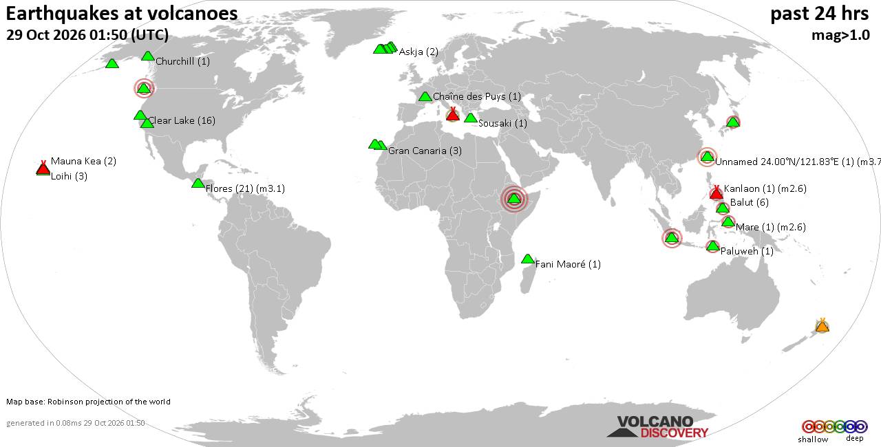
Volcano earthquake report for Thursday, 29 October 2026
• M 1.9 - 5 km WSW of Burning Man Earth, Nevada
• M 2.1 - 2 km E of Mountain Home, Arkansas
• M 2.5 - 95 km S of Sand Point, Alaska
• M 5.5 - 5 km ESE of Asahi, Japan
• M 5.0 - 43 km NNE of Semporna, Malaysia
|

#710659
Wed 31 Jan 2024 11:50:PM
|
Joined: Feb 2001
Posts: 678,977
Launch Director
|
|
Launch Director
Joined: Feb 2001
Posts: 678,977 |
Volcano earthquake report for Wednesday, 31 Jan 2024 World map showing volcanoes with shallow (less than 50 km) earthquakes within 20 km radius during the past 24 hours on 31 Jan 2024 Number in brackets indicate nr of quakes. Quakes detected near: Apaneca Range (1 quake mag 2.2), Bardarbunga (1 quake mag 1.3), Barva (7 quakes between mag 2.5-3.5), Buzzard Creek (1 quake mag 1.8), Chachimbiro (1 quake mag 3.0), Clear Lake (19 quakes between mag 0.3-1.7)
Coso (3 quakes between mag 1.1-1.3), Don Joao de Castro Bank (1 quake mag 2.2), Etna (1 quake mag 1.1), Fagradalsfjall (13 quakes between mag 0.1-1.3), Grímsvötn (3 quakes between mag 0.6-1.4), Hrómundartindur (5 quakes between mag 0.1-1.6), Imbabura (1 quake mag 3.0), Kalatungan (1 quake mag 2.7), Katla (2 quakes between mag 1.1-1.9), Kialagvik (1 quake mag 2.0), Kilauea (271 quakes between mag 0.6-3.4), Long Valley (1 quake mag 1.2), Maunaloa (2 quakes between mag 2.0-2.4), Mount Rainier (2 quakes between mag 0.6-1.1), Okataina (Tarawera) (1 quake mag 2.1), Reykjanes (13 quakes between mag 0.1-1.0), Ruapehu (3 quakes between mag 0.9-2.3), Sabancaya (1 quake mag 3.6), Tjörnes Fracture Zone (1 quake mag 1.5), West Mata (1 quake mag 5.1) (updated 23h50)
Note: Earthquakes within 20 km from and at depths less than 50 km under active volcanoes are reported. The list is not complete because many volcanoes are not monitored and/or seismic data in high resolution is not available publicly.
Volcanoes with recent earthquakes above magnitude 2 or more than 10 quakes are listed below:
Apaneca Range volcano (El Salvador): magnitude 2.2 earthquakeA magnitude 2.2 earthquake occurred at the volcano 17 hours ago. The quake, which might be volcanic in origin, was located at a depth of 11.0 km depth at 8 km distance E from the volcano. Earthquake details: 2.2 quake 20 km southwest of Santa Ana, El Salvador, Jan 31, 2024 12:32 am (El Salvador time) (8 km E) All earthquakes at Apaneca RangeBarva volcano (Costa Rica): 7 earthquakes up to magnitude 3.57 earthquakes occurred near (under) the volcano during 16 hours, the last being recorded quake 1 hour 45 minutes ago. Hypocenter depths ranged between 6.0 and 4.0 km. Earthquake details: (only 5 largest) 3.5 quake Costa Rica Jan 31, 2024 12:46 am (Costa Rica time) (14 km SSE) 3.5 quake Provincia de Heredia, 10.6 km north of San Jose, San José, Costa Rica, Jan 31, 2024 12:46 pm (Costa Rica time) (14 km SSE) 3.1 quake Provincia de Heredia, 10.1 km north of San Jose, San José, Costa Rica, Jan 31, 2024 12:02 pm (Costa Rica time) (14 km SSE) 3.1 quake Costa Rica Jan 31, 2024 12:02 am (Costa Rica time) (14 km SSE) 3.0 quake San Isidro, Provincia de Heredia, 9.7 km north of San Jose, Costa Rica, Jan 31, 2024 04:05 pm (Costa Rica time) (14 km SSE) All earthquakes at BarvaChachimbiro volcano (Ecuador): magnitude 3.0 earthquakeA magnitude 3.0 earthquake occurred at the volcano 23 hours ago. The quake, which might be volcanic in origin, was located at a depth of 10.0 km depth at 10 km distance SE from the volcano. Earthquake details: Reported seismic-like event (likely no quake): Near Ibarra, Imbabura, Ecuador, Jan 30, 2024 07:22 pm (GMT -5) (10 km SE) All earthquakes at ChachimbiroClear Lake volcano (California): 19 earthquakes up to magnitude 1.7Possible earthquake swarm: 19 earthquakes occurred near (under) the volcano during 21 hours, the last being recorded quake 3 hours ago. Hypocenter depths ranged between 8.4 and 0.2 km. Earthquake details: (only 5 largest) 1.7 quake Sonoma County, 13 mi southwest of Clearlake, Lake County, California, USA, Jan 31, 2024 12:55 pm (Los Angeles time) (18 km S) 1.7 quake Sonoma County, 15 mi southwest of Clearlake, Lake County, California, USA, Jan 31, 2024 09:23 am (Los Angeles time) (18 km SSW) 1.4 quake 25 mi north of Santa Rosa, Sonoma County, California, USA, Jan 31, 2024 02:00 am (Los Angeles time) (19 km S) 1.2 quake 28 mi north of Santa Rosa, Sonoma County, California, USA, Jan 31, 2024 03:05 am (Los Angeles time) (16 km SSW) 1.1 quake Lake County, 27 mi north of Santa Rosa, Sonoma County, California, USA, Jan 31, 2024 01:17 am (Los Angeles time) (16 km S) All earthquakes at Clear LakeDon Joao de Castro Bank volcano (Azores): magnitude 2.2 earthquakeA magnitude 2.2 earthquake occurred at the volcano 21 hours ago. The quake, which might be volcanic in origin, was located at a depth of 10.0 km depth at 12 km distance WNW from the volcano. Earthquake details: 2.2 quake North Atlantic Ocean, 59 km southeast of Angra do Heroismo, Azores, Portugal, Jan 31, 2024 01:53 am (GMT -1) (12 km WNW) All earthquakes at Don Joao de Castro BankFagradalsfjall volcano (Reykjanes Peninsula, Iceland): 13 earthquakes up to magnitude 1.3Possible earthquake swarm: 13 earthquakes occurred near (under) the volcano during 11 hours, the last being recorded quake 12 hours ago. Hypocenter depths ranged between 8.8 and 0.1 km. Earthquake details: (only 5 largest) 1.3 quake Iceland: 5.6 Km NNE of Grindavík Jan 31, 2024 01:53 am (Reykjavik time) (6 km WSW) 1.0 quake Iceland: 5.4 Km WSW of Fagradalsfjall Jan 31, 2024 05:11 am (Reykjavik time) (5 km WSW) 0.8 quake Iceland: 1.2 Km SSW of Fagradalsfjall Jan 31, 2024 12:12 pm (Reykjavik time) (1 km W) 0.8 quake Iceland: 2.1 Km SW of Fagradalsfjall Jan 31, 2024 04:25 am (Reykjavik time) (2 km WSW) 0.7 quake Iceland: 1.8 Km SSW of Fagradalsfjall Jan 31, 2024 01:02 am (Reykjavik time) (1 km WSW) All earthquakes at FagradalsfjallImbabura volcano (Ecuador): magnitude 3.0 earthquakeA magnitude 3.0 earthquake occurred at the volcano 18 hours ago. The quake, which might be volcanic in origin, was located at a depth of 10.0 km depth at 13 km distance NNE from the volcano. Earthquake details: Reported seismic-like event (likely no quake): 1.4 km northwest of Ibarra, Provincia de Imbabura, Ecuador, Jan 31, 2024 01:13 am (GMT -5) (13 km NNE) All earthquakes at ImbaburaKalatungan volcano (Mindanao): magnitude 2.7 earthquakeA magnitude 2.7 earthquake occurred at the volcano 3 hours ago. The quake, which might be volcanic in origin, was located at a depth of 4.0 km depth at 17 km distance SW from the volcano. Earthquake details: 2.7 quake 46 km west of Valencia, Province of Bukidnon, Northern Mindanao, Philippines, Feb 1, 2024 04:34 am (Manila time) (17 km SW) All earthquakes at KalatunganKilauea volcano (Hawai'i (Big Island)): 271 earthquakes up to magnitude 3.4Possible earthquake swarm: 271 earthquakes occurred near (under) the volcano during 24 hours, the last being recorded quake 10 minutes ago. Hypocenter depths ranged between 33.0 and 0.1 km. Earthquake details: (only 5 largest) 3.4 quake 27 mi southwest of Hilo, Hawaii County, USA, Jan 31, 2024 11:17 am (Honolulu time) (3 km SSE) 3.3 quake 29 mi southwest of Hilo, Hawaii County, USA, Jan 31, 2024 06:30 am (Honolulu time) (5 km S) 3.3 quake 26 mi southwest of Hilo, Hawaii County, USA, Jan 31, 2024 07:58 am (Honolulu time) (1 km ESE) 3.3 quake 27 mi southwest of Hilo, Hawaii County, USA, Jan 31, 2024 11:15 am (Honolulu time) (2 km SSE) 3.3 quake 28 mi southwest of Hilo, Hawaii County, USA, Jan 31, 2024 06:09 am (Honolulu time) (4 km S) All earthquakes at KilaueaMaunaloa volcano (Hawai'i (Big Island)): 2 earthquakes up to magnitude 2.42 earthquakes occurred near (under) the volcano during 1 hour 25 minutes, the last being recorded quake 3 hours ago. Hypocenter depths ranged between 8.0 and 3.8 km. Earthquake details: 2.4 quake 30 mi southwest of Hilo, Hawaii County, USA, Jan 31, 2024 09:42 am (Honolulu time) (15 km E) 2.0 quake 12 mi north of Pāhala, Hawaii County, USA, Jan 31, 2024 11:07 am (Honolulu time) (17 km SE) All earthquakes at MaunaloaOkataina (Tarawera) volcano (New Zealand): magnitude 2.1 earthquakeA magnitude 2.1 earthquake occurred at the volcano 13 hours ago. The quake, which might be volcanic in origin, was located at a depth of 48.1 km depth at 14 km distance SSE from the volcano. Earthquake details: 2.1 quake 29 km east of Rotorua, Bay of Plenty, New Zealand, Jan 31, 2024 11:33 pm (Auckland time) (14 km SSE) All earthquakes at Okataina (Tarawera)Reykjanes volcano (Reykjanes Peninsula, Iceland): 13 earthquakes up to magnitude 1.0Possible earthquake swarm: 13 earthquakes occurred near (under) the volcano during 12 hours, the last being recorded quake 11 hours ago. Hypocenter depths ranged between 5.8 and 0.1 km. Earthquake details: (only 5 largest) 1.0 quake Iceland: 1.3 Km NNW of Grindavík Jan 31, 2024 12:32 pm (Reykjavik time) (6 km SE) 0.7 quake Iceland: 1.4 Km NNW of Grindavík Jan 31, 2024 09:29 am (Reykjavik time) (6 km SE) 0.7 quake Iceland: 3.6 Km NNE of Grindavík Jan 31, 2024 06:50 am (Reykjavik time) (6 km ESE) 0.7 quake Iceland: 2.3 Km NNE of Grindavík Jan 31, 2024 07:29 am (Reykjavik time) (6 km SE) 0.7 quake Iceland: 2.3 Km N of Grindavík Jan 31, 2024 08:14 am (Reykjavik time) (5 km SE) All earthquakes at ReykjanesRuapehu volcano (North Island): 3 earthquakes up to magnitude 2.33 earthquakes occurred near (under) the volcano during 22 hours, the last being recorded quake 1 hour 17 minutes ago. Hypocenter depths ranged between 16.3 and 7.9 km. Earthquake details: 2.3 quake 28 km northwest of Waiouru, Ruapehu District, Manawatu-Wanganui, New Zealand, Feb 1, 2024 11:32 am (Auckland time) (16 km WSW) 1.1 quake Ruapehu District, 76 km northeast of Whanganui, New Zealand, Jan 31, 2024 12:15 pm (Auckland time) (14 km WSW) 0.9 quake Ruapehu District, 77 km northeast of Whanganui, New Zealand, Jan 31, 2024 08:20 pm (Auckland time) (12 km SSE) All earthquakes at RuapehuSabancaya volcano (Peru): magnitude 3.6 earthquakeA magnitude 3.6 earthquake occurred at the volcano 5 hours ago. The quake, which might be volcanic in origin, was located at a depth of 12.0 km depth at 3 km distance S from the volcano. Earthquake details: 3.6 quake Provincia de Caylloma, 64 km northwest of Cono Norte, Arequipa, Peru, Jan 31, 2024 02:06 pm (Lima time) (3 km S) All earthquakes at SabancayaWest Mata volcano (Tonga): magnitude 5.1 earthquakeA magnitude 5.1 earthquake occurred at the volcano 19 hours ago. The quake, which might be volcanic in origin, was located at a depth of 10.0 km depth at 17 km distance NE from the volcano. Earthquake details: 5.1 quake South Pacific Ocean, 239 km southwest of Apia, Tuamasaga, Samoa, Jan 31, 2024 05:35 pm (GMT +13) (17 km NE) All earthquakes at West Matahttps://www.volcanodiscovery.com/earthquakes-volcanoes/news/232831/Volcano-earthquake-report-for-Wednesday-31-Jan-2024.html
|
|



CMS The Best Conveyancing solicitors conveyancing quotes throughout the UK
For any webhosting enquiries please email webmaster@aus-city.com
|
|
Forums60
Topics900,683
Posts935,480
Members2,960
| |
Most Online102,106
Jul 10th, 2026
|
|
|
|
|

|









































