|
0 members (),
1,649
guests, and
21
robots. |
|
Key:
Admin,
Global Mod,
Mod
|
|
S |
M |
T |
W |
T |
F |
S |
|
1
|
2
|
3
|
4
|
5
|
6
|
7
|
|
8
|
9
|
10
|
11
|
12
|
13
|
14
|
|
15
|
16
|
17
|
18
|
19
|
20
|
21
|
|
22
|
23
|
24
|
25
|
26
|
27
|
28
|
|
29
|
30
|
|
|
|
|
|
|
There are no members with birthdays on this day. |
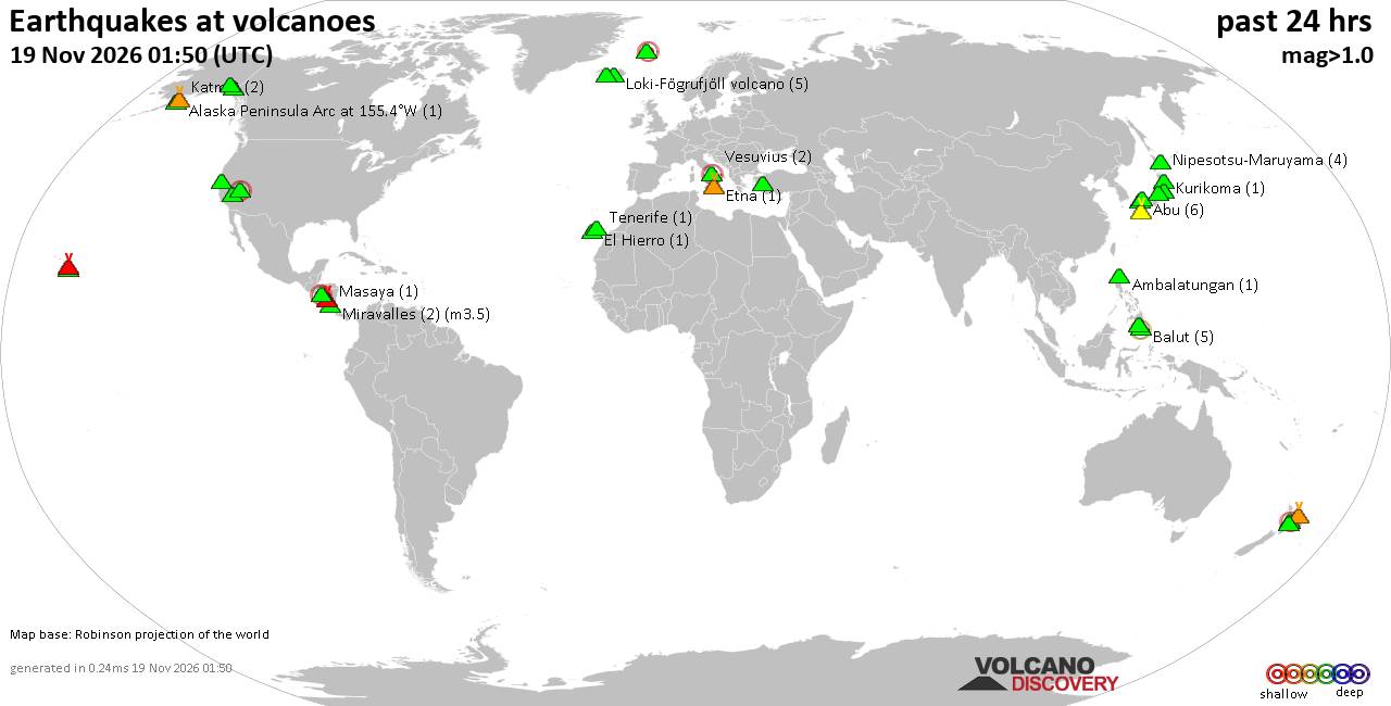
Volcano earthquake report for Thursday, 19 November 2026
• M 1.8 - 23 km WSW of Ackerly, Texas
• M 0.7 - 2 km N of The Geysers, CA
• M 1.9 - 23 km E of Beluga, Alaska
• M 1.3 - 1 km E of The Geysers, CA
• M 1.2 - 14 km NNE of Milford, Utah
|

#729961
Thu 25 Jul 2024 05:35:AM
|
Joined: Feb 2001
Posts: 800,656
Launch Director
|
|
Launch Director
Joined: Feb 2001
Posts: 800,656 |
SPC Jul 25, 2024 0600 UTC Day 2 Convective OutlookSPC 0600Z Day 2 Outlook 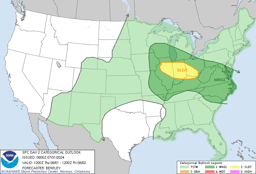
Day 2 Convective Outlook
NWS Storm Prediction Center Norman OK
1224 AM CDT Thu Jul 25 2024

Valid 261200Z - 271200Z

...THERE IS A MARGINAL RISK OF SEVERE THUNDERSTORMS ACROSS FAR
SOUTHEAST MONTANA AND NORTHEAST WYOMING INTO WESTERN SOUTH
DAKOTA...AND ACROSS FAR EASTERN NORTH DAKOTA INTO NORTHWEST
MINNESOTA...

...SUMMARY...
Isolated severe thunderstorms are possible across parts of the
northern High Plains and far eastern North Dakota into northwest
Minnesota on Friday.

...Synopsis...

A more progressive upper pattern in expected on Friday as an upper
trough develops westward across the western U.S. This will shunt the
Plains upper ridge east, extending from the Great Lakes, southward
to the Gulf Coast states. While the upper trough envelops much of
the western U.S., an upper anticyclone will remain centered over
northern Baja, and extend northeast into AZ/NM. At the surface, a
cold front will extend southward across the western Dakotas early in
the day. The northern extent of the front will develop east toward
the ND/MN border by 00z, while the SD portion of the front stalls
and becomes diffuse. Surface high pressure over the Great Lakes will
maintain a mostly dry airmass from the Ohio Valley into the
Northeast in the wake of a prior cold frontal passage. Meanwhile, a
baroclinic zone over the Upper Midwest will allow for rich boundary
layer moisture beneath the eastward-develop upper ridge.
Southwesterly low-level flow across northwest Mexico into AZ will
bring modest boundary-layer moisture into the southern AZ deserts as
well.

...WY into western SD and Vicinity...

Boundary-layer moisture is expected to modestly return in the wake
of the morning cold front as the boundary stalls over
western/central SD. Low-level flow is expected to become
east/southeasterly during the afternoon, allowing for modest
moisture return and destabilization in this post-frontal upslope
flow regime. Forecast guidance suggests at least isolated
thunderstorms will develop as large-scale ascent increases in
response to a shortwave impulse migrating through southwesterly
flow, generating modest height falls across the region. Forecast
soundings indicate a deeply mixed boundary layer with inverted-v
thermodynamic sub-cloud profiles amid 25 kt effective shear
magnitudes. Isolated strong/severe gusts may accompany thunderstorm
activity during the evening, especially if clustering/outflow
consolidation occurs.

...Eastern ND into MN...

Thunderstorms are expected to develop ahead of the
eastward-advancing cold front by late Friday afternoon as the
boundary impinges on richer boundary layer moisture. Initial capping
should erode as the upper ridge shifts east toward the Great Lakes,
resulting in falling heights/cooling aloft while warm advection
continues in the low-levels. Even if weak capping is maintained,
elevated convection is still expected. A narrow corridor of MLCAPE
up to 2500 J/kg is forecast amid effective shear magnitudes around
35 kt, supporting robust updrafts and marginal supercells. Isolated
hail will be possible in addition locally strong gusts.

...AZ...

Modest boundary layer moisture and steep lapse rates will support
around 500-1000 J/kg MLCAPE. Thunderstorms will once again develop
over higher terrain and move south during the evening. Mid and
upper-level flow will be a bit more northerly compared to the prior
few days and fairly weak (generally less than 15 kt). Nevertheless,
deep mixing and inverted-v thermodynamic profiles will support
sporadic strong gusts. Given somewhat less favorable flow compared
to recent days, will hold off on marginal wind probabilities at this
time.

..Leitman.. 07/25/2024
Read morehttps://www.spc.noaa.gov/products/outlook/day2otlk_0600.html
|
|



CMS The Best Conveyancing solicitors conveyancing quotes throughout the UK
For any webhosting enquiries please email webmaster@aus-city.com
|
|
Forums60
Topics936,067
Posts970,864
Members2,960
| |
Most Online102,106
Jul 10th, 2026
|
|
|









































