|
|
|
0 members (),
2,696
guests, and
28
robots. |
|
Key:
Admin,
Global Mod,
Mod
|
|
S |
M |
T |
W |
T |
F |
S |
|
|
|
1
|
2
|
3
|
4
|
5
|
|
6
|
7
|
8
|
9
|
10
|
11
|
12
|
|
13
|
14
|
15
|
16
|
17
|
18
|
19
|
|
20
|
21
|
22
|
23
|
24
|
25
|
26
|
|
27
|
28
|
29
|
30
|
|
|
|
|
There are no members with birthdays on this day. |
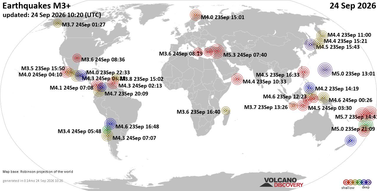
World Earthquake Report for Thursday, 24 September 2026
• Moderate mag. 4.3 earthquake - Madagascar: Mozambique Channel on Thursday, ...
• Small magnitude 3.9 earthquake hits near Hastings, Hastings District, Hawke...
• Volcano earthquake report for Thursday, 24 September 2026
• Light mag. 3.9 earthquake - South Pacific Ocean, 10.2 km south of Hastings,...
• Moderate magnitude 4.1 quake hits 31 miles southeast of Midland, Texas, Uni...
|

#732018
Tue 27 Aug 2024 05:13:PM
|
Joined: Feb 2001
Posts: 678,977
Launch Director
|
|
Launch Director
Joined: Feb 2001
Posts: 678,977 |
SPC Aug 27, 2024 1730 UTC Day 2 Convective OutlookSPC 1730Z Day 2 Outlook 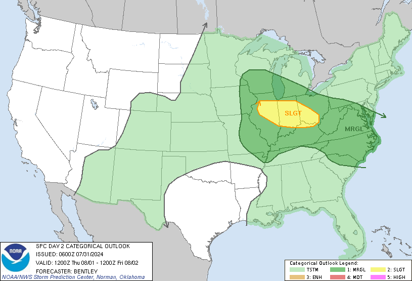
Day 2 Convective Outlook
NWS Storm Prediction Center Norman OK
1209 PM CDT Tue Aug 27 2024

Valid 281200Z - 291200Z

...THERE IS A SLIGHT RISK OF SEVERE THUNDERSTORMS ACROSS PORTIONS OF
THE DAKOTAS...AND FROM OHIO TO THE NORTHERN MID-ATLANTIC COAST...

...SUMMARY...
Severe thunderstorms are expected on Wednesday from parts of Ohio to
the northern Mid-Atlantic coast, and across parts of North and South
Dakota.

...Mid-MS/OH Valleys to the Mid-Atlantic...

Uncertainty remains this forecast cycle, particularly from around
central PA eastward to the northern Mid-Atlantic Coast/Chesapeake
Bay vicinity. Severe thunderstorm probabilities have been focused
along and just ahead of a southward sagging cold front and
instability gradient from central OH to the NJ coast. Rich
boundary-layer moisture (dewpoints in the upper 60s to mid 70s F)
will contribute to a corridor of MLCAPE around 2000-4000 J/kg from
the Mid-MS Valley eastward to the NJ coast. Warm midlevel
temperatures may lead to lingering inhibition, particularly across
eastern portions of the Slight and Marginal risk areas. Height falls
associated with troughing over eastern Canada will remain well north
of the region, and resulting in somewhat nebulous large-scale ascent
amid very modest vertical shear (effective shear magnitudes
generally less than 25 kt).

Convection from the Day 1/Tue period may be ongoing Wednesday
morning across parts of the Great Lakes vicinity and shift east
along the instability gradient/southward-sagging surface front
through the afternoon. Vertical shear may be locally enhanced with
any MCV that may be present with this activity, and damaging winds
are possible as the downstream boundary layer destabilizes.
Additional isolated thunderstorm development is possible from
central PA/northern VA eastward to the coast. This activity could
produce locally damaging gusts and perhaps small hail if capping can
be overcome and longer-lived updrafts develop.

Weak shear further west toward the Mid-MS Valley vicinity will
likely preclude a more organized severe risk. However, strong
heating amid the very moist/unstable airmass will support isolated
strong/locally damaging gusts during the afternoon.

...Northern Plains...

A robust upper cyclone will spread east from the northern Rockies to
the northern Plains on Wednesday. Enhanced mid/upper southwesterly
flow ahead of this feature will overspread the Dakotas, in
conjunction with stronger height falls, from late afternoon into the
overnight hours. At the surface, low pressure will deepen over the
northern High Plains during the day, resulting in an increasing
baroclinic zone across the northern Plains. Southeasterly low-level
flow will transport 60s F dewpoints northwest ahead of a
westward-advancing cold front. Steepening midlevel lapse rates and
favorable boundary-layer moisture will support a corridor of strong
instability (MLCAPE 2000-3000 J/kg). Forecast soundings indication
supercell wind profile, with greater than 40 kt effective shear
magnitudes and elongated/straight hodographs. Large hail, some
potential to 3 inch diameter, will be possible in addition to severe
wind gusts beginning near 00z and lingering into the nighttime
hours.

..Leitman.. 08/27/2024
Read morehttps://www.spc.noaa.gov/products/outlook/day2otlk_1730.html
|
|



CMS The Best Conveyancing solicitors conveyancing quotes throughout the UK
For any webhosting enquiries please email webmaster@aus-city.com
|
|
Forums60
Topics840,728
Posts875,523
Members2,960
| |
Most Online102,106
Jul 10th, 2026
|
|
|
|
|

|





































