|
1 members (Alisa),
1,459
guests, and
48
robots. |
|
Key:
Admin,
Global Mod,
Mod
|
|
S |
M |
T |
W |
T |
F |
S |
|
|
|
|
|
|
|
1
|
|
2
|
3
|
4
|
5
|
6
|
7
|
8
|
|
9
|
10
|
11
|
12
|
13
|
14
|
15
|
|
16
|
17
|
18
|
19
|
20
|
21
|
22
|
|
23
|
24
|
25
|
26
|
27
|
28
|
29
|
|
30
|
31
|
|
|
|
|
|
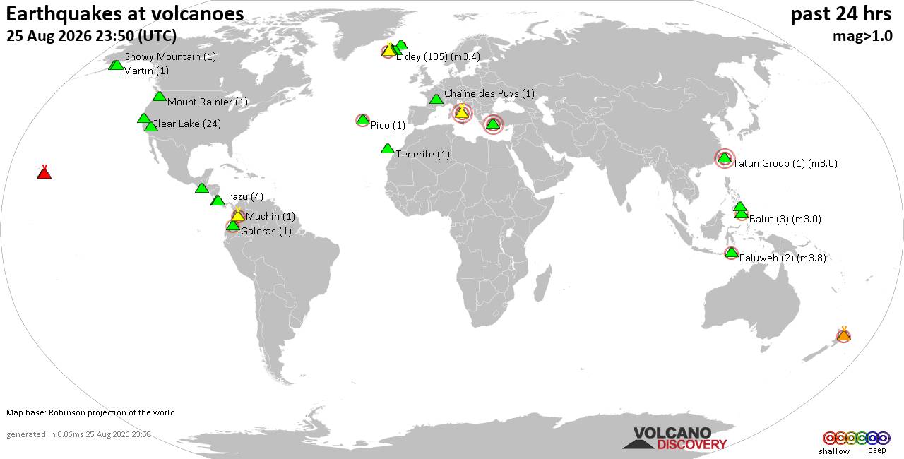
Volcano earthquake report for Tuesday, 25 Aug 2026
• M 2.1 - 61 km SW of Nanwalek, Alaska
• M 1.5 - 9 km WNW of The Geysers, CA
• M 0.3 - 4 km W of Cobb, CA
• M 4.8 - 76 km NNW of Ende, Indonesia
• M -0.2 - 10 km NW of The Geysers, CA
• M 0.3 - 7 km W of Cobb, CA
|

#738248
Tue 17 Sep 2024 04:30:PM
|
Joined: Feb 2001
Posts: 678,977
Launch Director
|
|
Launch Director
Joined: Feb 2001
Posts: 678,977 |
SPC Sep 17, 2024 1630 UTC Day 1 Convective OutlookSPC 1630Z Day 1 Outlook 
Day 1 Convective Outlook
NWS Storm Prediction Center Norman OK
1126 AM CDT Tue Sep 17 2024

Valid 171630Z - 181200Z

...THERE IS AN ENHANCED RISK OF SEVERE THUNDERSTORMS ACROSS PARTS OF
THE CENTRAL HIGH PLAINS...

...SUMMARY...
Thunderstorms capable of producing scattered to numerous severe wind
gusts and isolated large hail should occur this afternoon and
evening across much of the High Plains. Some of the wind gusts may
be significant (75+ mph).

...High Plains and Central/Southern Rockies...
Expansions have been made to the Slight and Enhanced Risks across
the northern/central High Plains to account for latest trends in
guidance and observations. The Marginal Risk has also been expanded
westward to include more of western CO and western/central WY, where
isolated strong to severe winds are already ongoing with high-based
convection.

A strong upper trough/low over the Great Basin will pivot
east-northeastward across the northern/central Rockies through this
evening. An associated 50-60 kt mid-level jet will move eastward
across the central/southern Rockies this afternoon, and over parts
of the adjacent High Plains through this evening. As large-scale
ascent with the upper trough and mid-level jet overspreads these
regions, a surface low is forecast to deepen over eastern MT through
this evening, while another low also develops over the central High
Plains. A surface trough will extend southward from the central High
Plains low, and it should sharpen as it develops eastward across the
central/southern High Plains through the day.

Greater low-level moisture, characterized by generally mid 50s to
low 60s surface dewpoints, will gradually increase today along/east
of the surface trough, while remaining more limited across the
higher terrain of the central/southern Rockies. Moderate instability
should develop to the east of the surface trough across much of the
High Plains through peak afternoon heating. Strengthening deep-layer
shear with the approach of the mid-level jet will support organized
convection, including some potential for initial supercells across
the northern High Plains (eastern MT and vicinity). Related threat
for large hail will exist with any of this more discrete convection.
Otherwise, thunderstorms will continue to develop this afternoon
over the central/southern Rockies while producing isolated strong to
severe wind gusts in a weakly unstable but strongly sheared
environment. This activity will eventually spread off the higher
terrain and into the central/southern High Plains.

Steepened low-level lapse rates with robust daytime heating, along
with more limited/shallow low-level moisture along/west of the
surface trough, will likely support a gradually increasing severe
wind threat with the high-based convection spreading
east-northeastward across the southern/central Rockies. As these
clusters and linear segments encounter greater low-level moisture
and related instability along/east of the surface trough across the
High Plains late this afternoon into early evening, the threat for
scattered to numerous severe wind gusts should increase. This may
particularly be the case across parts of the central High Plains,
where the best combination of steepened low-level lapse rates,
moderate instability, moderate to strong deep-layer shear, and
greatest linear convective signal exists in 12Z guidance. Some
chance for isolated gusts of 75+ mph may also be realized across
this region with the more intense clusters spreading
east-northeastward in tandem with the mid-level jet. The threat for
severe winds is expected to gradually decrease with eastward extent
across the Plains this evening as convection encounters increasing
MLCIN with nocturnal cooling of the boundary layer.

...Florida...
A weak mid/upper-level low will remain centered over the Southeast
today. Modest mid-level westerly flow will persist over FL on the
southern periphery of the upper low. Scattered to numerous
thunderstorms should develop later this afternoon along/south of a
remnant front, and along the Atlantic Coast sea breeze. Even with
daytime heating of a rather moist low-level airmass, poor mid-level
lapse rates should temper updraft intensities to some extent, even
as moderate instability develops. That said, the stronger cores may
be capable of producing isolated strong to damaging winds, with
20-25 kt of deep-layer shear aiding in modest thunderstorm
organization. Some adjustments have been made to the Marginal Risk
across parts of the FL Peninsula, based on latest observational
trends and 12Z guidance.

...Southeast Virginia/Northeast North Carolina...
A weak convective band is ongoing across far northeast NC into
southeast VA, on the northeast side of a mid/upper-level low over
the Southeast. Occasional strong/gusty winds may occur with the more
robust cores this afternoon as the convective band pivots further
into southeast VA. Even so, weak instability, modest low/mid-level
flow, and related weak shear should temper overall thunderstorm
organization. Accordingly, severe wind potential should remain low.

..Gleason/Moore.. 09/17/2024
Read morehttps://www.spc.noaa.gov/products/outlook/day1otlk_1630.html
|
|



CMS The Best Conveyancing solicitors conveyancing quotes throughout the UK
For any webhosting enquiries please email webmaster@aus-city.com
|
|
Forums60
Topics813,233
Posts848,026
Members2,960
| |
Most Online102,106
Jul 10th, 2026
|
|
|





































